Saldaş

Last updated

Coordinates: 39°15′04″N46°35′03″E / 39.25111°N 46.58417°E / 39.25111; 46.58417

Geographic coordinate system Coordinate system

A geographic coordinate system is a coordinate system that enables every location on Earth to be specified by a set of numbers, letters or symbols. The coordinates are often chosen such that one of the numbers represents a vertical position and two or three of the numbers represent a horizontal position; alternatively, a geographic position may be expressed in a combined three-dimensional Cartesian vector. A common choice of coordinates is latitude, longitude and elevation. To specify a location on a plane requires a map projection.

Saldaş
Azerbaijan adm location map.svg
Red pog.svg
Saldaş
Coordinates: 39°15′04″N46°35′03″E / 39.25111°N 46.58417°E / 39.25111; 46.58417
CountryFlag of Artsakh.svg  Artsakh ( de facto )
Flag of Azerbaijan.svg  Azerbaijan ( de jure )
Rayon Qubadli
Time zone AZT (UTC+4)
  Summer (DST) AZT (UTC+5)

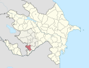
Saldaş (also, Soldaş and Saldash) is a village in the Qubadli Rayon of Azerbaijan.

Azerbaijan Republic in Western Asia and Eastern Europe

Azerbaijan, officially the Republic of Azerbaijan, is a landlocked country in the South Caucasus region of Eurasia at the crossroads of Eastern Europe and Western Asia. It is bounded by the Caspian Sea to the east, Russia to the north, Georgia to the northwest, Armenia to the west and Iran to the south. The exclave of Nakhchivan is bound by Armenia to the north and east, Iran to the south and west, and has an 11 km long border with Turkey in the northwest.

Related Research Articles

HTMS <i>Maeklong</i>

HTMS Maeklong was a Royal Thai Navy escort vessel and training ship, built at the Uraga Dock in Yokosuka, Japan.

Verkhnyaya Salda human settlement in Russia

Verkhnyaya Salda is a town in Sverdlovsk Oblast, Russia, located on the Salda River, 195 kilometers (121 mi) north of Yekaterinburg. Population: 46,221 (2010 Census); 51,195 (2002 Census); 55,246 (1989 Census).

Needmore, Brown County, Indiana Unincorporated community in Indiana, United States

Needmore is an unincorporated community in Jackson Township, Brown County, Indiana.

Bluffs, Indiana Unincorporated community in Indiana, United States

Bluffs is an unincorporated community in Harrison Township, Morgan County, in the U.S. state of Indiana.

Wilbury Hill Camp is a late Bronze Age hill fort southwest of Letchworth in Hertfordshire. It and Arbury Banks near Ashwell are two of a line of six similar hill forts along the northern Chilterns. It is a scheduled ancient monument. The site is marked by two circular defences formed by single banks and external ditches. Although these are no longer conspicuous on the ground, distinct cropmarks generated by the buried features have been recorded by aerial photography since the 1950s.

The canton of Bourbon-l'Archambault is an administrative division in central France. At the French canton reorganisation which came into effect in March 2015, the canton was expanded from 8 to 29 communes :

Apaga, Armenia Place in Armavir, Armenia

Apaga is a town in the Armavir Province of Armenia.

Aramus, Armenia Place in Kotayk, Armenia

Aramus is a town in the Kotayk Province of Armenia.

Chknagh Place in Aragatsotn, Armenia

Chknagh is a town in the Aragatsotn Province of Armenia.

Vank, Armenia Place in Syunik, Armenia

Vank (վանք) is a village in the Syunik Province of Armenia.

Çardaqlı, Tartar Place in Tartar

Çardaqlı is a village in the Tartar Rayon of Azerbaijan.

Kyurdalilyar Place in Goygol, Azerbaijan

Kyurdalilyar is a village in the Goygol Rayon of Azerbaijan.

Anykh-Kishlag Place in Qusar, Azerbaijan

Anykh-Kishlag is a village in the Qusar Rayon of Azerbaijan.

Sadłowice, Świętokrzyskie Voivodeship Village in Świętokrzyskie, Poland

Sadłowice is a village in the administrative district of Gmina Wojciechowice, within Opatów County, Świętokrzyskie Voivodeship, in south-central Poland. It lies approximately 8 kilometres (5 mi) south of Wojciechowice, 12 km (7 mi) east of Opatów, and 70 km (43 mi) east of the regional capital Kielce.

Cranberry Lake may refer to:

Chrášťany is a municipality and village in Benešov District in the Central Bohemian Region of the Czech Republic.

Detuo Town in Sichuan, China

Detuo is a town in the Garzê Tibetan Autonomous Prefecture of Sichuan, China.

Menzilovići Village in Republika Srpska, Bosnia and Herzegovina

Menzilovići is a village in the municipality of Višegrad, Bosnia and Herzegovina.

Sutro, Nevada is a ghost town in Lyon County, Nevada, where the Sutro Tunnel is located.

References

The GEOnet Names Server (GNS) provides access to the National Geospatial-Intelligence Agency's (NGA) and the U.S. Board on Geographic Names's (BGN) database of geographic feature names and locations for locations outside the United States. The database is the official repository of foreign place-name decisions approved by the US BGN. Approximately 20,000 of the database's features are updated monthly. The database never removes an entry, "except in cases of obvious duplication".