Jurm District is one of the 28 districts of Badakhshan Province in northeast Afghanistan. The district capital is a town named Jurm. The district is 3 hours from the center of the province in Fayzabad, and is home to approximately 3,000 residents, making it one of the most sparsely populated portions of the province. The highest point of the Afghan Hindu Kush is located in Jurm District, at 6729 meters. The district consist of clusters and villages. Ferghamenj, Kyb, Kyteb, Ularyb,Ferghameru, Khustak, and Iskan are the clusters. Each cluster contain villages; the district is largely Tajik speaking.

Spearsville is an unincorporated community in Hamblen Township, Brown County, Indiana.
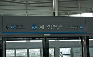
Gyeyang Station is the northern terminus of Line 1 of the Incheon Subway. It is also a railway station on the AREX, a railway linking Seoul Station and Incheon International Airport.

Agarakadzor is a village in the Vayots Dzor Province of Armenia. 2 km from the village is a 13th-century bridge that once served as the main route to Julfa. 2 km east of Agarakadzor is a 13-15th century cemetery.
Voghji, is a former village in Syunik Province of Armenia, currently part of town of Kajaran.

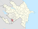
Yuxarı Maralyan is a village in the Jabrayil Rayon of Azerbaijan.
Şahsevən is a village and municipality in the Kurdamir Rayon of Azerbaijan.
Sumnerville is an unincorporated community in Ottawa County, Kansas, United States, located north of Minneapolis and Interstate 70.

Prokowskie Chrósty is a village in the administrative district of Gmina Kartuzy, within Kartuzy County, Pomeranian Voivodeship, in northern Poland. It lies approximately 3 kilometres (2 mi) north of Kartuzy and 29 km (18 mi) west of the regional capital Gdańsk.
Bukowo is a village in the administrative district of Gmina Bartoszyce, within Bartoszyce County, Warmian-Masurian Voivodeship, in northern Poland, close to the border with the Kaliningrad Oblast of Russia.
Daesin Station is a railway station on the Gyeongbu Line.

Pyongyang Station is the central railway station of P'yŏngyang, North Korea. It is located in Yŏkchŏn-dong, Chung-guyŏk.
Porta Vigentina was one of the city gates in the Spanish walls of Milan, Italy; the gate has since been demolished, but the phrase "Porta Vigentina" is still used to refer to the district ("quartiere") where the gate used to be. The area is part of the Zone 5 administrative division of Milan.
Naistevälja is a village in Tapa Parish, Lääne-Viru County, in northeastern Estonia. It was the birthplace of Hans Verner Puurand, who was the founder of Estonian Marineforces.

Standard is an unincorporated community in Curry Township, Sullivan County, in the U.S. state of Indiana.

Slatina is a village in the municipality of Srebrenica, Bosnia and Herzegovina.
Sakété II is an arrondissement in the Plateau department of Benin. It is an administrative division under the jurisdiction of the commune of Sakété. According to the population census conducted by the Institut National de la Statistique Benin on February 15, 2002, the arrondissement had a total population of 8,419.

Massies Creek is a stream located entirely within Greene County, Ohio. It is a tributary of the Little Miami River.
Barkley is an unincorporated community in Marion County, in the U.S. state of Missouri.
Cashtown is an unincorporated community in Franklin County, in the U.S. state of Pennsylvania.