Suyunush-Aga

Last updated

Coordinates: 39°15′N46°43′E / 39.250°N 46.717°E / 39.250; 46.717

Geographic coordinate system Coordinate system

A geographic coordinate system is a coordinate system that enables every location on Earth to be specified by a set of numbers, letters or symbols. The coordinates are often chosen such that one of the numbers represents a vertical position and two or three of the numbers represent a horizontal position; alternatively, a geographic position may be expressed in a combined three-dimensional Cartesian vector. A common choice of coordinates is latitude, longitude and elevation. To specify a location on a plane requires a map projection.

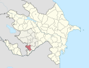
Suyunush-Aga
Azerbaijan adm location map.svg
Red pog.svg
Suyunush-Aga
Coordinates: 39°15′N46°43′E / 39.250°N 46.717°E / 39.250; 46.717
CountryFlag of Artsakh.svg  Nagorno-Karabakh Republic ( de facto )
Flag of Azerbaijan.svg  Azerbaijan ( de jure )
Rayon Qubadli
Time zone AZT (UTC+4)
  Summer (DST) AZT (UTC+5)

Suyunush-Aga is a village in the Qubadli Rayon of Azerbaijan.

Azerbaijan Republic in Western Asia and Eastern Europe

Azerbaijan, officially the Republic of Azerbaijan, is a landlocked country in the South Caucasus region of Eurasia at the crossroads of Eastern Europe and Western Asia. It is bounded by the Caspian Sea to the east, Russia to the north, Georgia to the northwest, Armenia to the west and Iran to the south. The exclave of Nakhchivan is bound by Armenia to the north and east, Iran to the south and west, and has an 11 km long border with Turkey in the northwest.


Related Research Articles

Arctic Archipelago Canadian archipelago

The Arctic Archipelago, also known as the Canadian Arctic Archipelago, is a group of islands north of the Canadian mainland.

Ilyinka is the name of several inhabited localities in Russia.

Yémeda is a municipality in Cuenca, Castile-La Mancha, Spain. It has a population of 29.

Eldijk is a village in the Netherlands and it is part of the Coevorden municipality in Drenthe. Its altitude is 11 meters (39 feet).

Agăș Commune in Bacău County, Romania

Agăș is a commune in Bacău County, Romania. It is composed of eight villages: Agăș, Beleghet, Coșnea, Cotumba, Diaconești, Goioasa, Preluci and Sulța.

Şotlanlı, Qubadli Place in Qubadli

Şotlanlı is a village in the Qubadli Rayon of Azerbaijan.

Üçüncü Ağalı Place in Zangilan, Azerbaijan

Üçüncü Ağalı is a village in the Zangilan Rayon of Azerbaijan.

İkinci Ağalı Place in Zangilan, Azerbaijan

İkinci Ağalı is a village in the Zangilan Rayon of Azerbaijan.

Birinci Ağalı Place in Zangilan, Azerbaijan

Birinci Ağalı is a village in the Zangilan Rayon of Azerbaijan.

Qilican is a village in the Qubadli Rayon of Azerbaijan.

Harghita Mountains mountain range

The Harghita Mountains is a volcanic mountain range of the Căliman-Harghita Mountains in Harghita County of Romania, part of the Inner Eastern Carpathians.

Hagyárosbörönd is a village in Zala County, Hungary.

Kávás is a village in Zala County, Hungary.

Márokföld is a village in Zala County, Hungary.

Pördefölde is a village in Zala County, Hungary.

Zalaszentmihály is a village in Zala County, Hungary.

Aksay is the name of several inhabited localities in Russia.

References