Nowe Mosty is a village in the administrative district of Gmina Łasin, within Grudziądz County, Kuyavian-Pomeranian Voivodeship, in north-central Poland. It lies approximately 6 kilometres (4 mi) west of Łasin, 16 km (10 mi) east of Grudziądz, and 60 km (37 mi) north-east of Toruń.
Zarzecze is a village in the administrative district of Gmina Wolbrom, within Olkusz County, Lesser Poland Voivodeship, in southern Poland. It lies approximately 7 kilometres (4 mi) south-west of Wolbrom, 14 km (9 mi) north-east of Olkusz, and 38 km (24 mi) north-west of the regional capital Kraków.
Gózd is a village in the administrative district of Gmina Harasiuki, within Nisko County, Subcarpathian Voivodeship, in south-eastern Poland. It lies approximately 6 kilometres (4 mi) north-west of Harasiuki, 21 km (13 mi) east of Nisko, and 62 km (39 mi) north-east of the regional capital Rzeszów.
Wolica is a village in the administrative district of Gmina Gać, within Przeworsk County, Subcarpathian Voivodeship, in south-eastern Poland. It lies approximately 5 kilometres (3 mi) east of Gać, 8 km (5 mi) south-west of Przeworsk, and 30 km (19 mi) east of the regional capital Rzeszów.
Jagiełła is a village in the administrative district of Gmina Tryńcza, within Przeworsk County, Subcarpathian Voivodeship, in south-eastern Poland. It lies approximately 8 kilometres (5 mi) south of Tryńcza, 7 km (4 mi) north-east of Przeworsk, and 41 km (25 mi) east of the regional capital Rzeszów.
Maćkówka is a village in the administrative district of Gmina Zarzecze, within Przeworsk County, Subcarpathian Voivodeship, in south-eastern Poland. It lies approximately 6 kilometres (4 mi) north of Zarzecze, 4 km (2 mi) south of Przeworsk, and 37 km (23 mi) east of the regional capital Rzeszów.
Parcelacja Rożniatowska is a village in the administrative district of Gmina Zarzecze, within Przeworsk County, Subcarpathian Voivodeship, in south-eastern Poland. It lies approximately 2 kilometres (1 mi) south-west of Zarzecze, 11 km (7 mi) south of Przeworsk, and 38 km (24 mi) east of the regional capital Rzeszów.
Pełnatycze is a village in the administrative district of Gmina Zarzecze, within Przeworsk County, Subcarpathian Voivodeship, in south-eastern Poland. It lies approximately 3 kilometres (2 mi) south-east of Zarzecze, 12 km (7 mi) south of Przeworsk, and 40 km (25 mi) east of the regional capital Rzeszów.
Rożniatów is a village in the administrative district of Gmina Zarzecze, within Przeworsk County, Subcarpathian Voivodeship, in south-eastern Poland. It lies approximately 10 km (6 mi) south of Przeworsk and 39 km (24 mi) east of the regional capital Rzeszów.
Siennów is a village in the administrative district of Gmina Zarzecze, within Przeworsk County, Subcarpathian Voivodeship, in south-eastern Poland. It lies approximately 4 kilometres (2 mi) south-west of Zarzecze, 12 km (7 mi) south of Przeworsk, and 37 km (23 mi) east of the regional capital Rzeszów.
Zalesie Żurowskie is a village in the administrative district of Gmina Zarzecze, within Przeworsk County, Subcarpathian Voivodeship, in south-eastern Poland.
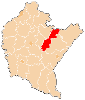
Zarzecze is a village in Przeworsk County, Subcarpathian Voivodeship, in south-eastern Poland. It is the seat of the gmina called Gmina Zarzecze. It lies approximately 10 kilometres (6 mi) south of Przeworsk and 39 km (24 mi) east of the regional capital Rzeszów.
Żurawiczki is a village in the administrative district of Gmina Zarzecze, within Przeworsk County, Subcarpathian Voivodeship, in south-eastern Poland. It lies approximately 4 kilometres (2 mi) north-west of Zarzecze, 6 km (4 mi) south of Przeworsk, and 37 km (23 mi) east of the regional capital Rzeszów.
Grzęska is a village in the administrative district of Gmina Przeworsk, within Przeworsk County, Subcarpathian Voivodeship, in south-eastern Poland. It lies approximately 3 kilometres (2 mi) west of Przeworsk and 34 km (21 mi) east of the regional capital Rzeszów.
Żabia Wola is a village in the administrative district of Gmina Stara Błotnica, within Białobrzegi County, Masovian Voivodeship, in east-central Poland. It lies approximately 4 kilometres (2 mi) south of Stara Błotnica, 16 km (10 mi) south of Białobrzegi, and 78 km (48 mi) south of Warsaw.
Marynino is a village in the administrative district of Gmina Serock, within Legionowo County, Masovian Voivodeship, in east-central Poland. It lies approximately 5 kilometres (3 mi) west of Serock, 15 km (9 mi) north-east of Legionowo, and 34 km (21 mi) north of Warsaw. Marynino is a rural area with only a few roads and many family farms.
Kamianka is a village in the administrative district of Gmina Rzekuń, within Ostrołęka County, Masovian Voivodeship, in east-central Poland. It lies approximately 10 kilometres (6 mi) south-west of Rzekuń, 9 km (6 mi) south-west of Ostrołęka, and 94 km (58 mi) north of Warsaw.
Miszewko Garwackie is a village in the administrative district of Gmina Bodzanów, within Płock County, Masovian Voivodeship, in east-central Poland. It lies approximately 3 kilometres (2 mi) north-west of Bodzanów, 21 km (13 mi) east of Płock, and 76 km (47 mi) north-west of Warsaw.
Międzyleś is a village in the administrative district of Gmina Miedzna, within Węgrów County, Masovian Voivodeship, in east-central Poland. It lies approximately 9 kilometres (6 mi) north-west of Miedzna, 13 km (8 mi) north of Węgrów, and 76 km (47 mi) north-east of Warsaw.