Gmina Pawłosiów is a rural gmina in Jarosław County, Subcarpathian Voivodeship, in south-eastern Poland. Its seat is the village of Pawłosiów, which lies approximately 5 kilometres (3 mi) south-west of Jarosław and 47 km (29 mi) east of the regional capital Rzeszów.

Kisielów is a village in the administrative district of Gmina Zarzecze, within Przeworsk County, Podkarpackie Voivodeship, in south-eastern Poland.
Łapajówka is a village in the administrative district of Gmina Zarzecze, within Przeworsk County, Subcarpathian Voivodeship, in south-eastern Poland. It lies approximately 3 kilometres (2 mi) north-west of Zarzecze, 8 km (5 mi) south of Przeworsk, and 37 km (23 mi) east of the regional capital Rzeszów.
Maćkówka is a village in the administrative district of Gmina Zarzecze, within Przeworsk County, Subcarpathian Voivodeship, in south-eastern Poland. It lies approximately 6 kilometres (4 mi) north of Zarzecze, 4 km (2 mi) south of Przeworsk, and 37 km (23 mi) east of the regional capital Rzeszów.
Pełnatycze is a village in the administrative district of Gmina Zarzecze, within Przeworsk County, Subcarpathian Voivodeship, in south-eastern Poland. It lies approximately 3 kilometres (2 mi) south-east of Zarzecze, 12 km (7 mi) south of Przeworsk, and 40 km (25 mi) east of the regional capital Rzeszów.
Rożniatów is a village in the administrative district of Gmina Zarzecze, within Przeworsk County, Subcarpathian Voivodeship, in south-eastern Poland. It lies approximately 10 km (6 mi) south of Przeworsk and 39 km (24 mi) east of the regional capital Rzeszów.
Siennów is a village in the administrative district of Gmina Zarzecze, within Przeworsk County, Subcarpathian Voivodeship, in south-eastern Poland. It lies approximately 4 kilometres (2 mi) south-west of Zarzecze, 12 km (7 mi) south of Przeworsk, and 37 km (23 mi) east of the regional capital Rzeszów.
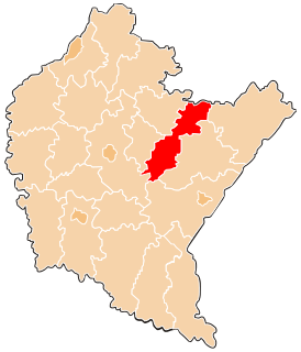
Zarzecze is a village in Przeworsk County, Subcarpathian Voivodeship, in south-eastern Poland. It is the seat of the gmina called Gmina Zarzecze. It lies approximately 10 kilometres (6 mi) south of Przeworsk and 39 km (24 mi) east of the regional capital Rzeszów.
Żurawiczki is a village in the administrative district of Gmina Zarzecze, within Przeworsk County, Subcarpathian Voivodeship, in south-eastern Poland. It lies approximately 4 kilometres (2 mi) north-west of Zarzecze, 6 km (4 mi) south of Przeworsk, and 37 km (23 mi) east of the regional capital Rzeszów.
Chodakówka is a village in the administrative district of Gmina Kańczuga, within Przeworsk County, Subcarpathian Voivodeship, in south-eastern Poland. It lies approximately 8 kilometres (5 mi) south-west of Kańczuga, 18 km (11 mi) south-west of Przeworsk, and 24 km (15 mi) east of the regional capital Rzeszów.
Krzeczowice is a village in the administrative district of Gmina Kańczuga, within Przeworsk County, Subcarpathian Voivodeship, in south-eastern Poland. It lies approximately 5 kilometres (3 mi) south-east of Kańczuga, 10 km (6 mi) south of Przeworsk, and 33 km (21 mi) east of the regional capital Rzeszów.
Lipnik is a village in the administrative district of Gmina Kańczuga, within Przeworsk County, Subcarpathian Voivodeship, in south-eastern Poland. It lies approximately 8 kilometres (5 mi) west of Kańczuga, 18 km (11 mi) south-west of Przeworsk, and 22 km (14 mi) east of the regional capital Rzeszów.
Łopuszka Wielka is a village in the administrative district of Gmina Kańczuga, within Przeworsk County, Subcarpathian Voivodeship, in south-eastern Poland. It lies approximately 8 kilometres (5 mi) south of Kańczuga, 17 km (11 mi) south-west of Przeworsk, and 31 km (19 mi) east of the regional capital Rzeszów.
Medynia Kańczucka is a village in the administrative district of Gmina Kańczuga, within Przeworsk County, Subcarpathian Voivodeship, in south-eastern Poland. It lies approximately 8 kilometres (5 mi) south of Kańczuga, 18 km (11 mi) south-west of Przeworsk, and 29 km (18 mi) south-east of the regional capital Rzeszów.
Niżatyce is a village in the administrative district of Gmina Kańczuga, within Przeworsk County, Subcarpathian Voivodeship, in south-eastern Poland. It lies approximately 3 kilometres (2 mi) south-east of Kańczuga, 11 km (7 mi) south-west of Przeworsk, and 30 km (19 mi) east of the regional capital Rzeszów.
Pantalowice is a village in the administrative district of Gmina Kańczuga, within Przeworsk County, Subcarpathian Voivodeship, in south-eastern Poland. It lies approximately 7 kilometres (4 mi) south-east of Kańczuga, 14 km (9 mi) south of Przeworsk, and 34 km (21 mi) east of the regional capital Rzeszów.
Rączyna is a village in the administrative district of Gmina Kańczuga, within Przeworsk County, Subcarpathian Voivodeship, in south-eastern Poland. It lies approximately 10 kilometres (6 mi) south of Kańczuga, 18 km (11 mi) south of Przeworsk, and 35 km (22 mi) east of the regional capital Rzeszów.
Siedleczka is a village in the administrative district of Gmina Kańczuga, within Przeworsk County, Subcarpathian Voivodeship, in south-eastern Poland. It lies approximately 5 kilometres (3 mi) south-west of Kańczuga, 15 km (9 mi) south-west of Przeworsk, and 27 km (17 mi) east of the regional capital Rzeszów.
Bukownica is a village in the administrative district of Gmina Krobia, within Gostyń County, Greater Poland Voivodeship, in west-central Poland. It lies approximately 4 kilometres (2 mi) north of Krobia, 8 km (5 mi) south of Gostyń, and 65 km (40 mi) south of the regional capital Poznań.