The Mutha River is a river in western Maharashtra, India. It arises in the Western Ghats and flows eastward until it merges with the Mula River in the city of Pune. It has been dammed twice, first at the Panshet Dam, used as a source of drinking water for Pune city and irrigation. The water released here is dammed again at Khadakwasla and is an important source of drinking water for Pune. One more dam has been built later on the Mutha river at Temghar.

Crveni Krst is one of five city municipalities which constitute the city of Niš. The municipality has a population of 31,762 inhabitants.
The Woody Hayes Athletic Center is an indoor athletics training facility of The Ohio State University. It was dedicated in November 1987 in memory of Woody Hayes, Ohio State's football coach, and renovated in a significant expansion in 2005–2007. The facility contains an indoor field which is 400 feet (120 m) long, 220 feet (67 m) wide and 65 feet (20 m) high and is covered by All-Pro Turf. The field is used by the football, baseball, softball, lacrosse and soccer teams.
Koohrang is the name of a river, originating in the Zagros mountains of western Iran, which joins the Beheštābād river to form the Karun, Iran's largest river. A series of tunnels have been built since the 1950s to redirect some of the Kuhrang's water toward the Zayandeh River to meet the demands of increased population in Esfahan and Yazd provinces.

Panków is a village in the administrative district of Gmina Świdnica, within Świdnica County, Lower Silesian Voivodeship, in south-western Poland. Prior to 1945 it was in Germany.

Carvel is a hamlet in Alberta, Canada within Parkland County. It is located on Highway 770, approximately 35 kilometres (22 mi) west of Edmonton. The hamlet's name is derived from the novel Richard Carvel by the American writer Winston Churchill.
Navan District is one of six districts of the province Oyón in Peru.

Hulcze is a village in the administrative district of Gmina Dołhobyczów, within Hrubieszów County, Lublin Voivodeship, in eastern Poland, close to the border with Ukraine. It lies approximately 10 kilometres (6 mi) south of Dołhobyczów, 37 km (23 mi) south of Hrubieszów, and 132 km (82 mi) south-east of the regional capital Lublin.
Brzeźno is a village in the administrative district of Gmina Szczuczyn, within Grajewo County, Podlaskie Voivodeship, in north-eastern Poland. It lies approximately 8 kilometres (5 mi) south-west of Szczuczyn, 22 km (14 mi) south-west of Grajewo, and 80 km (50 mi) north-west of the regional capital Białystok.
Kuścin is a settlement in the administrative district of Gmina Kuźnica, within Sokółka County, Podlaskie Voivodeship, in north-eastern Poland, close to the border with Belarus. It lies approximately 4 kilometres (2 mi) north-west of Kuźnica, 17 km (11 mi) north-east of Sokółka, and 55 km (34 mi) north-east of the regional capital Białystok.
Dziekanowice is a village in the administrative district of Gmina Zielonki, within Kraków County, Lesser Poland Voivodeship, in southern Poland. It lies approximately 9 km (6 mi) north-east of the regional capital Kraków. The village is located in the historical region Galicia.
Huta Tarnawacka is a village in the administrative district of Gmina Tarnawatka, within Tomaszów Lubelski County, Lublin Voivodeship, in eastern Poland.
Wierzbica is a village in the administrative district of Gmina Tuczępy, within Busko County, Świętokrzyskie Voivodeship, in south-central Poland. It lies approximately 3 kilometres (2 mi) north-east of Tuczępy, 23 km (14 mi) east of Busko-Zdrój, and 49 km (30 mi) south-east of the regional capital Kielce.
Mroczkówki is a settlement in the administrative district of Gmina Zarszyn, within Sanok County, Subcarpathian Voivodeship, in south-eastern Poland. It lies approximately 6 kilometres (4 mi) south of Zarszyn, 15 km (9 mi) west of Sanok, and 56 km (35 mi) south of the regional capital Rzeszów.
Wilcze Błota Kościerskie is a village in the administrative district of Gmina Stara Kiszewa, within Kościerzyna County, Pomeranian Voivodeship, in northern Poland. It lies approximately 3 kilometres (2 mi) north of Stara Kiszewa, 18 km (11 mi) south-east of Kościerzyna, and 50 km (31 mi) south-west of the regional capital Gdańsk.
Łężyce is a village in the administrative district of Gmina Wejherowo, within Wejherowo County, Pomeranian Voivodeship, in northern Poland. It lies approximately 12 kilometres (7 mi) south-east of Wejherowo and 25 km (16 mi) north-west of the regional capital Gdańsk.
Staniewo is a settlement in the administrative district of Gmina Reszel, within Kętrzyn County, Warmian-Masurian Voivodeship, in northern Poland. It lies approximately 7 kilometres (4 mi) south-east of Reszel, 14 km (9 mi) south-west of Kętrzyn, and 54 km (34 mi) north-east of the regional capital Olsztyn.
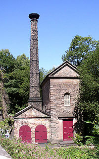
The Leawood Pump House was built near Cromford, Derbyshire, England in 1849 to supply water to the Cromford Canal, built some 50 years previously. It is a Grade II* listed building.
Rītabuļļi is a neighbourhood of Riga, the capital of Latvia.
Dantebad is an aquatics venue located in the greater Munich, Germany area. During the 1972 Summer Olympics, it hosted preliminaries for the water polo competition.