Krajna is a former village in the administrative district of Gmina Bircza, within Przemyśl County, Subcarpathian Voivodeship, in south-eastern Poland. It lies approximately 5 kilometres (3 mi) south-east of Bircza, 22 km (14 mi) south-west of Przemyśl, and 56 km (35 mi) south-east of the regional capital Rzeszów.
Szpaki is a village in the administrative district of Gmina Wyszki, within Bielsk County, Podlaskie Voivodeship, in north-eastern Poland. It lies approximately 4 kilometres (2 mi) south of Wyszki, 16 km (10 mi) west of Bielsk Podlaski, and 36 km (22 mi) south of the regional capital Białystok.
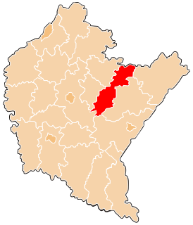
Gałęzów is a village in the administrative district of Gmina Bychawa, within Lublin County, Lublin Voivodeship, in eastern Poland. It lies approximately 4 kilometres (2 mi) south of Bychawa and 30 km (19 mi) south of the regional capital Lublin.

Oksiutycze is a village in the administrative district of Gmina Mielnik, within Siemiatycze County, Podlaskie Voivodeship, in north-eastern Poland, close to the border with Belarus. It lies approximately 11 kilometres (7 mi) north-west of Mielnik, 9 km (6 mi) east of Siemiatycze, and 79 km (49 mi) south of the regional capital Białystok.

Polany is a village in the administrative district of Gmina Krynica-Zdrój, within Nowy Sącz County, Lesser Poland Voivodeship, in southern Poland, close to the border with Slovakia. It lies approximately 14 kilometres (9 mi) north of Krynica-Zdrój, 23 km (14 mi) south-east of Nowy Sącz, and 96 km (60 mi) south-east of the regional capital Kraków.
Laskowa is a village in the administrative district of Gmina Zator, within Oświęcim County, Lesser Poland Voivodeship, in southern Poland. It lies approximately 3 kilometres (2 mi) south-east of Zator, 19 km (12 mi) south-east of Oświęcim, and 35 km (22 mi) west of the regional capital Kraków.
Trzebieńczyce is a village in the administrative district of Gmina Zator, within Oświęcim County, Lesser Poland Voivodeship, in southern Poland. It lies approximately 3 kilometres (2 mi) south-east of Zator, 19 km (12 mi) south-east of Oświęcim, and 35 km (22 mi) west of the regional capital Kraków.
Jaroszowice is a village in the administrative district of Gmina Wadowice, within Wadowice County, Lesser Poland Voivodeship, in southern Poland. It lies approximately 4 kilometres (2 mi) south-east of Wadowice and 37 km (23 mi) south-west of the regional capital Kraków.
Zaleska Wola is a village in the administrative district of Gmina Radymno, within Jarosław County, Subcarpathian Voivodeship, in south-eastern Poland, close to the border with Ukraine. It lies approximately 13 kilometres (8 mi) east of Radymno, 23 km (14 mi) east of Jarosław, and 71 km (44 mi) east of the regional capital Rzeszów.
Handzlówka is a village in the administrative district of Gmina Łańcut, within Łańcut County, Subcarpathian Voivodeship, in south-eastern Poland. It lies approximately 10 kilometres (6 mi) south of Łańcut and 18 km (11 mi) east of the regional capital Rzeszów.
Manasterz is a village in the administrative district of Gmina Jawornik Polski, within Przeworsk County, Subcarpathian Voivodeship, in south-eastern Poland. It lies approximately 10 kilometres (6 mi) north-east of Jawornik Polski, 17 km (11 mi) south-west of Przeworsk, and 28 km (17 mi) east of the regional capital Rzeszów.
Zagórze is a village in the administrative district of Gmina Jawornik Polski, within Przeworsk County, Subcarpathian Voivodeship, in south-eastern Poland. It lies approximately 10 kilometres (6 mi) north-east of Jawornik Polski, 17 km (11 mi) south-west of Przeworsk, and 28 km (17 mi) east of the regional capital Rzeszów.
Wola Rafałowska is a village in the administrative district of Gmina Chmielnik, within Rzeszów County, Subcarpathian Voivodeship, in south-eastern Poland. It lies approximately 3 kilometres (2 mi) east of Chmielnik and 14 km (9 mi) south-east of the regional capital Rzeszów.
Nowosielce Kozickie is a village in the administrative district of Gmina Ustrzyki Dolne, within Bieszczady County, Subcarpathian Voivodeship, in south-eastern Poland. It lies approximately 16 kilometres (10 mi) north of Ustrzyki Dolne and 65 km (40 mi) south-east of the regional capital Rzeszów.
Lipianka is a village in the administrative district of Gmina Goworowo, within Ostrołęka County, Masovian Voivodeship, in east-central Poland. It lies approximately 10 kilometres (6 mi) north of Goworowo, 10 km (6 mi) south of Ostrołęka, and 93 km (58 mi) north-east of Warsaw.
Mnichy is a village in the administrative district of Gmina Międzychód, within Międzychód County, Greater Poland Voivodeship, in west-central Poland. It lies approximately 11 kilometres (7 mi) south-east of Międzychód and 66 km (41 mi) west of the regional capital Poznań.
Ostrówek is a village in the administrative district of Gmina Orchowo, within Słupca County, Greater Poland Voivodeship, in west-central Poland. It lies approximately 3 kilometres (2 mi) north-west of Orchowo, 28 km (17 mi) north of Słupca, and 74 km (46 mi) east of the regional capital Poznań.
Łoje is a village in the administrative district of Gmina Kalinowo, within Ełk County, Warmian-Masurian Voivodeship, in northern Poland. It lies approximately 12 kilometres (7 mi) south-west of Kalinowo, 12 km (7 mi) east of Ełk, and 134 km (83 mi) east of the regional capital Olsztyn.
Knis is a village in the administrative district of Gmina Ryn, within Giżycko County, Warmian-Masurian Voivodeship, in northern Poland. It lies approximately 6 kilometres (4 mi) north of Ryn, 17 km (11 mi) south-west of Giżycko, and 72 km (45 mi) east of the regional capital Olsztyn.
Giętlewo is a village in the administrative district of Gmina Ostróda, within Ostróda County, Warmian-Masurian Voivodeship, in northern Poland. It lies approximately 19 kilometres (12 mi) south of Ostróda and 44 km (27 mi) south-west of the regional capital Olsztyn.