Suodenniemi is a former municipality of southwestern Finland.
Mirbat is a coastal town in the Dhofar governorate, in southwestern Oman. It is located at about 16°59′19″N54°41′32″E. It was the site of the 1972 Battle of Mirbat between Communist guerrillas on one side and the Armed forces of the Sultan of Oman and their Special Air Service advisers.

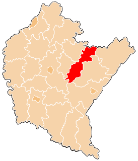
Cona County is a county of Shannan located in the south of the Tibet Autonomous Region, People's Republic of China.

Kimmel, Algeria is a town in north-eastern Algeria.

Highway 71 is an east-west highway that passes through the eastern Jezreel Valley and the Beit She'an Valley, below the north slopes of the Gilboa mountains, in northern Israel. The road follows a path parallel to the Harod Creek in Harod Valley and to the Jezreel Valley railway. The road is 35 kilometres (22 mi) long, and it leads from Afula in the west, via Beit She'an, and it terminates at a border crossing on the Jordan River.
Ghazni Khel is a town and union council of Lakki Marwat District in Khyber Pakhtunkhwa province of Pakistan. It is located at 32°33'30N 70°44'22E and has an altitude of 287 metres. It is located 30 km south to Serai Naurang.

Nowawieś Chełmińska is a village in the administrative district of Gmina Chełmno, within Chełmno County, Kuyavian-Pomeranian Voivodeship, in north-central Poland. It lies 10 kilometres (6 mi) east of Chełmno, 38 km (24 mi) north of Toruń, and 47 km (29 mi) north-east of Bydgoszcz.
Mała Huta is a village in the administrative district of Gmina Suwałki, within Suwałki County, Podlaskie Voivodeship, in north-eastern Poland. It lies approximately 5 kilometres (3 mi) north-east of Suwałki and 110 km (68 mi) north of the regional capital Białystok.
Walinna is a village in the administrative district of Gmina Komarówka Podlaska, within Radzyń Podlaski County, Lublin Voivodeship, in eastern Poland. It lies approximately 5 kilometres (3 mi) north-east of Komarówka Podlaska, 26 km (16 mi) east of Radzyń Podlaski, and 71 km (44 mi) north-east of the regional capital Lublin.
Nadole is a village in the administrative district of Gmina Dukla, within Krosno County, Subcarpathian Voivodeship, in south-eastern Poland, close to the border with Slovakia. It lies approximately 2 kilometres (1 mi) south-west of Dukla, 16 km (10 mi) south-west of Krosno, and 59 km (37 mi) south-west of the regional capital Rzeszów.
Budzyń is a village in Chodzież County, Greater Poland Voivodeship, in west-central Poland. It is the seat of the gmina called Gmina Budzyń. It lies approximately 12 kilometres (7 mi) south-east of Chodzież and 55 km (34 mi) north of the regional capital Poznań.
Mielnik is a village in the administrative district of Gmina Lipiany, within Pyrzyce County, West Pomeranian Voivodeship, in north-western Poland.

Počaply is a village and municipality in Příbram District in the Central Bohemian Region of the Czech Republic.
Hamdallaye, Niger is a village and rural commune in Niger. It is the location of the US Peace Corps training site.
Kalâa Seghira is a town and commune in the Sousse Governorate, Tunisia. As of 2004 it had a population of 25,078.

Gornje Krajince is a village in the municipality of Leskovac, Serbia. According to the 2002 census, the village has a population of 786 people.
Oberwaldberg is a mountain of Hesse, Germany.
Lauri is a village in Kanepi Parish, Põlva County in southeastern Estonia.
Groenenhagen-Tuinenhoven is a neighborhood of Rotterdam, Netherlands.

Kusanagi Athletic Stadium (静岡県草薙総合運動場陸上競技場) is an athletic stadium in Shizuoka, Shizuoka, Japan.