Gmina Kańczuga is an urban-rural gmina in Przeworsk County, Subcarpathian Voivodeship, in south-eastern Poland. Its seat is the town of Kańczuga, which lies approximately 11 kilometres (7 mi) south-west of Przeworsk and 29 km (18 mi) east of the regional capital Rzeszów.
Gmina Przeworsk is a rural gmina in Przeworsk County, Subcarpathian Voivodeship, in south-eastern Poland. Its seat is the town of Przeworsk, although the town is not part of the territory of the gmina.

Ostrów is a village in the administrative district of Gmina Gać, within Przeworsk County, Subcarpathian Voivodeship, in south-eastern Poland. It lies approximately 4 kilometres (2 mi) east of Gać, 9 km (6 mi) south-west of Przeworsk, and 29 km (18 mi) east of the regional capital Rzeszów.
Jagiełła is a village in the administrative district of Gmina Tryńcza, within Przeworsk County, Subcarpathian Voivodeship, in south-eastern Poland. It lies approximately 8 kilometres (5 mi) south of Tryńcza, 7 km (4 mi) north-east of Przeworsk, and 41 km (25 mi) east of the regional capital Rzeszów.
Wólka Małkowa is a village in the administrative district of Gmina Tryńcza, within Przeworsk County, Subcarpathian Voivodeship, in south-eastern Poland. It lies approximately 6 kilometres (4 mi) south-west of Tryńcza, 8 km (5 mi) north of Przeworsk, and 39 km (24 mi) east of the regional capital Rzeszów.
Wólka Ogryzkowa is a village in the administrative district of Gmina Tryńcza, within Przeworsk County, Subcarpathian Voivodeship, in south-eastern Poland. It lies approximately 4 kilometres (2 mi) south of Tryńcza, 9 km (6 mi) north-east of Przeworsk, and 42 km (26 mi) east of the regional capital Rzeszów.
Łapajówka is a village in the administrative district of Gmina Zarzecze, within Przeworsk County, Subcarpathian Voivodeship, in south-eastern Poland. It lies approximately 3 kilometres (2 mi) north-west of Zarzecze, 8 km (5 mi) south of Przeworsk, and 37 km (23 mi) east of the regional capital Rzeszów.
Maćkówka is a village in the administrative district of Gmina Zarzecze, within Przeworsk County, Subcarpathian Voivodeship, in south-eastern Poland. It lies approximately 6 kilometres (4 mi) north of Zarzecze, 4 km (2 mi) south of Przeworsk, and 37 km (23 mi) east of the regional capital Rzeszów.
Parcelacja Rożniatowska is a village in the administrative district of Gmina Zarzecze, within Przeworsk County, Subcarpathian Voivodeship, in south-eastern Poland. It lies approximately 2 kilometres (1 mi) south-west of Zarzecze, 11 km (7 mi) south of Przeworsk, and 38 km (24 mi) east of the regional capital Rzeszów.
Pełnatycze is a village in the administrative district of Gmina Zarzecze, within Przeworsk County, Subcarpathian Voivodeship, in south-eastern Poland. It lies approximately 3 kilometres (2 mi) south-east of Zarzecze, 12 km (7 mi) south of Przeworsk, and 40 km (25 mi) east of the regional capital Rzeszów.
Rożniatów is a village in the administrative district of Gmina Zarzecze, within Przeworsk County, Subcarpathian Voivodeship, in south-eastern Poland. It lies approximately 10 km (6 mi) south of Przeworsk and 39 km (24 mi) east of the regional capital Rzeszów.
Siennów is a village in the administrative district of Gmina Zarzecze, within Przeworsk County, Subcarpathian Voivodeship, in south-eastern Poland. It lies approximately 4 kilometres (2 mi) south-west of Zarzecze, 12 km (7 mi) south of Przeworsk, and 37 km (23 mi) east of the regional capital Rzeszów.
Zalesie Żurowskie is a village in the administrative district of Gmina Zarzecze, within Przeworsk County, Subcarpathian Voivodeship, in south-eastern Poland.
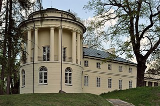
Zarzecze is a village in Przeworsk County, Subcarpathian Voivodeship, in south-eastern Poland. It is the seat of the gmina called Gmina Zarzecze. It lies approximately 10 kilometres (6 mi) south of Przeworsk and 39 km (24 mi) east of the regional capital Rzeszów.
Studzian is a village in the administrative district of Gmina Przeworsk, within Przeworsk County, Subcarpathian Voivodeship, in south-eastern Poland. It lies approximately 4 kilometres (2 mi) south-west of Przeworsk and 34 km (21 mi) east of the regional capital Rzeszów.
Świętoniowa is a village in the administrative district of Gmina Przeworsk, within Przeworsk County, Subcarpathian Voivodeship, in south-eastern Poland. It lies approximately 7 kilometres (4 mi) north-west of Przeworsk and 32 km (20 mi) east of the regional capital Rzeszów.
Ujezna is a village in the administrative district of Gmina Przeworsk, within Przeworsk County, Subcarpathian Voivodeship, in south-eastern Poland. It lies approximately 6 kilometres (4 mi) east of Przeworsk and 42 km (26 mi) east of the regional capital Rzeszów.
Urzejowice is a village in the administrative district of Gmina Przeworsk, within Przeworsk County, Subcarpathian Voivodeship, in south-eastern Poland. It lies approximately 7 kilometres (4 mi) south-west of Przeworsk and 34 km (21 mi) east of the regional capital Rzeszów.
Czerce is a village in the administrative district of Gmina Sieniawa, within Przeworsk County, Subcarpathian Voivodeship, in south-eastern Poland. It lies approximately 6 kilometres (4 mi) south-east of Sieniawa, 16 km (10 mi) north-east of Przeworsk, and 50 km (31 mi) east of the regional capital Rzeszów.


