It is proposed that this article be deleted because of the following concern:
If you can address this concern by improving, copyediting, sourcing, renaming, or merging the page, please edit this page and do so. You may remove this message if you improve the article or otherwise object to deletion for any reason. Although not required, you are encouraged to explain why you object to the deletion, either in your edit summary or on the talk page. If this template is removed, do not replace it . The article may be deleted if this message remains in place for seven days, i.e., after 13:49, 10 December 2018 (UTC).
Nominator: Please consider notifying the author/project: {{subst:proposed deletion notify |2009 Tonga earthquake|concern=[[Wikipedia:WikiProject Earthquakes|WikiProject Earthquakes]] is not documenting insignificant events like this one, either as standalone articles ''or'' as list entries. Our efforts are instead being focused on creating complete, interesting, and encyclopedic articles that require significant coverage. This one fails multiple aspects of [[WP:EVENT]] and our own [[Wikipedia:Notability (earthquakes)|notability guidelines]] because of the following concerns: *This was a felt event only *Nothing encyclopedic or educational about it}} ~~~~ |
 | |
| UTC time | ?? |
|---|---|
| ISC event | |
| USGS-ANSS | |
| Date * | March 19, 2009 |
| Local date | |
| Local time | |
| Magnitude | 7.6 Mw [1] |
| Depth | 40 km (25 mi) [1] |
| Epicenter | 23°08′S174°35′W / 23.13°S 174.58°W [1] |
| Areas affected | Tonga |
| Max. intensity | VII (Very strong) [2] |
| * Deprecated | See documentation. |
The 2009 Tonga earthquake occurred on March 19 at 18:17:41 UTC with a moment magnitude of 7.6 and a maximum Mercalli intensity of VII (Very strong). The event occurred several hundred kilometers to the southeast of Nuku'alofa (the capital of Tonga), and was felt 3,000 kilometres (1,900 mi) distant on New Zealand's North Island, but there were no injuries or significant damage. [3] A tsunami warning was issued but was later cancelled. [4]
The moment magnitude scale is a measure of n earthquake's magnitude based on its seismic moment, expressed in terms of the familiar magnitudes of the original "Richter" magnitude scale.

New Zealand is a sovereign island country in the southwestern Pacific Ocean. The country geographically comprises two main landmasses—the North Island, and the South Island —and around 600 smaller islands. New Zealand is situated some 2,000 kilometres (1,200 mi) east of Australia across the Tasman Sea and roughly 1,000 kilometres (600 mi) south of the Pacific island areas of New Caledonia, Fiji, and Tonga. Because of its remoteness, it was one of the last lands to be settled by humans. During its long period of isolation, New Zealand developed a distinct biodiversity of animal, fungal, and plant life. The country's varied topography and its sharp mountain peaks, such as the Southern Alps, owe much to the tectonic uplift of land and volcanic eruptions. New Zealand's capital city is Wellington, while its most populous city is Auckland.
The earthquake occurred four days after the beginning of a major undersea volcanic eruption near Hunga Tonga. There has been no confirmation yet of a direct link between the volcanic eruption and earthquake, but Ken Hudnut, a geophysicist for the United States Geological Survey, stated that "it seems suggestive at this point". [4] Keleti Mafi, the Tongan government's chief seismologist, has suggested that the earthquake is likely to have a direct impact on the volcanic eruption, stating that the "strength of the earthquake could crack the volcano's (undersea) vent and allow more magma to be ejected". [5]
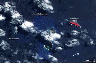
The 2009 Tonga undersea volcanic eruption began on March 16, 2009, near the island of Hunga Tonga, approximately 11 kilometres (6.8 mi) from the Tongan capital of Tongatapu. The volcano is in a highly active volcanic region that represents a portion of the Pacific Ring of Fire. It is estimated that there are up to 36 undersea volcanoes clustered together in the area.

Hunga Tonga-Hunga Haʻapai is a volcano located about 30 kilometres south-southeast of Fonuafoʻou, an island which is part of the nation of Tonga.

The United States Geological Survey is a scientific agency of the United States government. The scientists of the USGS study the landscape of the United States, its natural resources, and the natural hazards that threaten it. The organization has four major science disciplines, concerning biology, geography, geology, and hydrology. The USGS is a fact-finding research organization with no regulatory responsibility.