2011 Sindh floods

Last updated

2011 Sindh floods
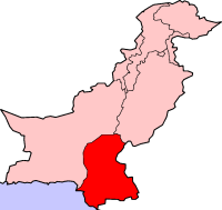
PakistanSindh.png
Location of Sindh,
DateAugust 2011 – September 2011
Location Sindh, southern Balochistan, eastern Punjab and Azad Kashmir
DeathsAt least 434 dead, 8.9 million affected
Property damage8.9 million affected, 2.7 million children affected, 6.79 million acres land damaged, 1.52 million homes damaged [1]

The 2011 Sindh floods was the highest-ever recorded rainfall between 11 August 2011, and 14 September 2011 in Sindh Province, Pakistan.

Contents

Heavy rainfall was the main cause of the 2011 Sindh floods. After 15 September 2011, water receded from the inundated area at the rate of 167 square kilometers a day. [2] Unprecedented, torrential monsoon rains caused severe flooding in 16 districts of the Sindh province. [3] The flooding followed the previous year's historic 2010 Pakistan floods, which devastated the entire country. [4]

An estimated 434 civilians were killed while 5.3 million people and 1,524,773 homes were affected. [4]

Causes

In the month of July, Pakistan received below-normal monsoon rains. However, in August and September, the country received above-normal monsoon rains. A strong weather pattern entered Sindh and adjacent areas from the Indian states of Rajasthan and Gujarat in August. The strong weather gained strength and resulted in heavy downpours. The four weeks of continuous rain had created an unprecedented flood situation in Sindh. [3] [5] [6]

The Badin district of the Sindh province received a record-breaking rainfall of 615.3 millimeters (24.22 in) during the monsoon spell exceeding the earlier record of 121 millimeters (4.8 in) dating back to 1936.

The area of Mithi also received a record rainfall of 1,290 millimeters (51 in) during the spell. The previous maximum rainfall there was recorded 114 millimeters (4.5 in) in 2004. The cloudburst causing incessant rain within a span of 72 hours displaced many people as well as destroying crops in the area.

The met office had informed the Provincial Disaster Management Authority, all district coordination officers, the offices of the chief minister and chief secretary about the heavy monsoon rain-spell two days earlier to allow them to take precautionary measures.

The flood was so severe that it inundated 3820.39 square kilometers in Badin, 1836.26 square kilometers in Mirpur Khas, 1352.32 square kilometers in Jacobabad, 1597.50 square kilometers in Shahdadkot, 1887.57 square kilometers in Dadu, and 2494.18 square kilometers in Sanghar. Furthermore, the above-mentioned districts comprised 61% of the total inundated areas spread over 23 districts of Sindh. [2]

According to Qamar uz Zaman Chaudhry, director general of the Pakistan Meteorological Department,

"The rains in Sindh were the highest ever recorded monsoon rains during the four-week period between August and September 2011. Before the start of these rains in the second week of August, Sindh was under severe drought conditions and it had not received any rainfall in the preceding 12 months....The last severe rainfall flooding in Sindh occurred in July 2003... but this time the devastating rains in Mithi, Mirpur Khas, Diplo, Parker, Nawabshah, Badin, Chhor, Padidan, and Hyderabad during the four-week period have created unprecedented flood situation in Sindh."

According to Dr. Qamar, the total volume of water fallen over Sindh during the four weeks was estimated to be above 37 million acre-feet, "which is unimaginable". [3] The August monsoon rainfall, over the province of Sindh (271% above normal) is the heaviest recorded during the period 1961–2011. [7]

Torrential rainfall recorded in August and September in Sindh

The following table documents the heavy rainfalls recorded in Sindh province in the months of August and September 2011 based on the data from the Pakistan Meteorological Department. [8] The first monsoon spell hit the southern parts of Sindh on 10 August. It produced record-breaking widespread torrential rainfalls and resulted in floods in the district of Badin. The second spell hit the areas on 30 August and lasted until 2 September.

In the month of September, four more consecutive spells of monsoon rainfall devastated the southern parts of the province. The first spell of September hit the already inundated parts of the province on 2 September. Thereafter, the second spell hit on 5 September, the third on 9 September, and the fourth on 12 September 2011. [9] The four spells of monsoon produced even more devastating torrential rains in the already affected areas of Sindh. [3]

CityAugust Rainfall (mm)Rainfall (in)September Rainfall (mm)Rainfall (in)Total Rainfall (mm)Total Rainfall (in)NotesReferences
Mithi 530*21.0760*30.01290*51.0 [A] [3] [10] [11]
Mirpur Khas 263.1*10.3603*23.7866.1*34.1 [A] [3] [10] [11]
Nawabshah 275.2*10.8353.2*13.9628.4*24.7 [A] [3] [10] [11]
Badin 331.2*13.0284.111.1615.3*24.2 [A] [3] [10] [11]
Chhor 27610.926810.6544*21.4 [A] [3] [10] [11]
Dadu 134.15.2348.113.7482.2*18.9 [A] [3] [10] [11]
Padidan 251.29.81726.8423.2*16.6 [A] [3] [10] [11]
Hyderabad 162.26.3244.29.6406.416.0 [3] [10] [11]
Karachi 61.22.4212.28.3273.310.7 [3] [10] [11]

* Indicates new record.

Heaviest spell of monsoon rains of 2011 in Sindh

The following table indicates the amount of rainfall recorded during the monsoon spell in Sindh province in the months of August and September 2011 based on data from the Pakistan Meteorological Department. [8]

CityRainfall (mm)Rainfall (in)Monsoon SpellNotes
Mithi 76030.01 to 14 September* [10] [11]
Mirpur Khas 60323.71 to 14 September [10] [11]
Padidan 35614.030 August to 4 September* [10] [11]
Nawabshah 353.213.91 to 14 September [10] [11]
Dadu 348.113.71 to 14 September [10] [11]
Badin 302.111.810 to 14 August* [10] [11]
Chhor 26810.61 to 14 September [10] [11]
Hyderabad 244.29.61 to 14 September [10] [11]
Karachi 212.28.31 to 14 September [10] [11]

Flooding and impact

Millions of people were affected due to the heavy rains that started in August, coinciding with monsoon season. Villages become particularly affected.

The area of Sanghar was declared as the most dangerous region. In the aftermath of the monsoon rains, Oxfam warned that aid should be provided to Pakistanis or they will die. Approximately, 8,920,631 people were affected as a result of the floods and 433 people are said to have been killed. [12]

Sindh is considered a fertile region and often called the "breadbasket" of the country due to its agricultural output. The impact of the 2011 flood on the local agrarian economy was substantial. At least 1.7 million acres of arable land was inundated as a result of the flooding. [4]
Protests by flood victims

As a result of the substantial flooding, some of the Pakistanis affected began protesting the government's response as slow and inadequate. Aid organisations reported that some ruling party politicians and officials are distributing aid only to their party supporters and people from their villages. [13]

Health concerns

Spread of disease

Gastroenteritis and malaria killed many infected people.

Domestic reaction

A special wing of the ministry of the Government of Sindh has been created to deal with the flooding and its effects. The Chief Minister of Sindh, Qaim Ali Shah, has visited the effected areas, announcing a million rupees in relief for each flood victim. Various politicians also engaged in setting up relief camps for the victims. A helpline 0800-11-121 was set up for the victims.

The Pakistani Army and Navy actively engaged in flood relief and victim support. According to aid organisation Save the Children, the flooding is more disastrous than that during the 2004 tsunami. [13]

International reactions to the floods

See also

Notes

A. ^ Indicates new record. Record-breaking torrential monsoon rains in Sindh.

Related Research Articles

<span class="mw-page-title-main">Cloudburst</span> Short and very intense rain

A cloudburst is a enormous amount of precipitation in a short period of time, sometimes accompanied by hail and thunder, which is capable of creating flood conditions. Cloudbursts can quickly dump large amounts of water, e.g. 25 mm of the precipitation corresponds to 25,000 metric tons per square kilometre. However, cloudbursts are infrequent as they occur only via orographic lift or occasionally when a warm air parcel mixes with cooler air, resulting in sudden condensation. At times, a large amount of runoff from higher elevations is mistakenly conflated with a cloudburst. The term "cloudburst" arose from the notion that clouds were akin to water balloons and could burst, resulting in rapid precipitation. Though this idea has since been disproven, the term remains in use.

Karachi has a tropical semi arid climate, albeit a moderate version of this climate, influenced by monsoons. Karachi has a tropical climate, despite being located slightly above the Tropic of Cancer. It is situated in the monsoon region of Pakistan. It is located on the coast bordering the Arabian Sea, and as a result, has a relatively mild climate. However, in more recent years, rainfall has become more abundant, with annual rainfall projected to reach over 500 mm by 2100. For this reason, the city may be classed as almost semi-arid (BSh), since it has a mild climate with a short but defined wet season, along with a lengthy dry season.

<span class="mw-page-title-main">2003 North Indian Ocean cyclone season</span>

The 2003 North Indian Ocean cyclone season was the last season that tropical cyclones were not publicly labeled by India Meteorological Department (IMD). Also was mostly focused in the Bay of Bengal, where six of the seven depressions developed. The remaining system was a tropical cyclone that developed in the Arabian Sea in November, which was also the only system that did not affect land. There were three cyclonic storms, which was below the average of 4–6. Only one storm formed before the start of the monsoon season in June, although it was also the most notable. On May 10, a depression formed in the central Bay of Bengal, and within a few days became a very severe cyclonic storm. After it stalled, it drew moisture from the southwest to produce severe flooding across Sri Lanka, killing 254 people and becoming the worst floods there since 1947. Damage on the island totaled $135 million (2003 USD). The storm eventually made landfall in Myanmar on May 19. It is possible that the storm contributed to a deadly heat wave in India due to shifting air currents.

<span class="mw-page-title-main">Climate of Pakistan</span>

Pakistan's climate varies from a continental type of climate in the north (Gilgit-Baltistan,Kashmir,KPK), a mountainous dry climate in the west (Baluchistan), a wet climate in the East (Punjab) an arid climate in the Thar Desert, to a tropical climate in the southeast (Sindh), characterized by extreme variations in temperature, both seasonally and daily, because it is located on a great landmass barely north of the Tropic of Cancer.

The province of Sindh is situated in a tropical region, with subtropical regions in the northern sections; it is hot, humid and very rainy in the summer and cold and dry in winter. Temperatures frequently rise above 46 °C (115 °F) between May and August, and the minimum average temperature of 2 °C (36 °F) occurs during December and January. The annual rainfall averages about nearly 13 inches (330 mm), falling mainly during June and September. The southwesterly monsoon wind begins to blow in mid-February and continues until the end of September, whereas the cool northerly wind blows during the winter months from October to January.

<span class="mw-page-title-main">Cyclone Phet</span> North Indian cyclone in 2010

Very Severe Cyclonic Storm Phet was a powerful tropical cyclone that made landfall on Oman, Western India, and Pakistan. The third named cyclone of the 2010 cyclone season, Phet developed in the Arabian Sea on May 31 to the west of India. With conducive environmental conditions, the storm intensified to reach peak sustained winds of 155 km/h (95 mph) on June 2, based on analysis by the India Meteorological Department (IMD). On the next day, Phet dropped heavy rainfall while moving across eastern Oman, with a peak of 603 mm (23.7 in) in Qurayyat. The rains flooded arid areas and collected into wadis – normally dry river beds. Thousands of homes were wrecked across Oman. There were 24 fatalities in the country, and damage was estimated at US$780 million.

<span class="mw-page-title-main">2010 Pakistan floods</span> 2010 natural disaster in Pakistan

The floods in Pakistan began in late July 2010, resulting from heavy monsoon rains in the Khyber Pakhtunkhwa, Sindh, Punjab and, Balochistan regions of Pakistan, which affected the Indus River basin. Approximately one-fifth of Pakistan's total land area was affected by floods, with the Khyber Pakhtunkhwa province facing the brunt of the damage and casualties. Nationwide, there were 1,985 deaths. According to Pakistani government data, the floods directly affected about 20 million people, mostly by destruction of property, livelihood and infrastructure.

<span class="mw-page-title-main">Climate of Lahore</span>

Lahore features a five-season semi-arid climate, bordering a humid subtropical climate, with five seasons: foggy winter with few western disturbances causing rain; pleasant spring ; summer with dust, rain storms and heat wave periods; rainy monsoon ; and dry autumn. However, in some cases, it can be classified as being humid subtropical (Cwa), rather than semi-arid, since it has well defined seasons and an ample amount of rain. It occasionally has very prolonged and dense monsoons, typical of a humid subtropical climate.

Quetta, Pakistan features a continental semi-arid climate with a large variation between summer and winter temperatures. The highest temperature recorded in Quetta was 42 °C (108 °F) on 10 July 1998. The lowest temperature in Quetta is −18.3 °C (−0.9 °F) which was recorded on 8 January 1970.

<span class="mw-page-title-main">2010 Gascoyne River flood</span> 2010 severe flood along the Gascoyne River in Western Australia

The 2010 Gascoyne River flood was regarded as the most severe flood to take place along the Gascoyne River in Western Australia on record. Triggered by record-breaking rainfall, amounting to over 6,000 percent of the monthly mean, 313.6 mm (12.35 in) and 5 mm (0.20 in) respectively, in just four days, the floods caused widespread damage in the region. By 17 December, the river began to rise in response to the heavy rains, eventually exceeding its banks within two days. Water levels reached record values at three stations along the river, cresting at 15.53 m (51.0 ft) near Fishy Pool. Evacuation orders were issued for several towns affected by rising waters. The most substantial impact was felt in Carnarvon where entire homes were washed away. Following the disaster, emergency supplies and funds were distributed to affected residents to aid them in restoring their livelihoods. Though no people died in the event, an estimated two thousand head of cattle perished and damage was estimated at A$100 million.

<span class="mw-page-title-main">2011 Balochistan floods</span>

The 2011 Balochistan floods started from the last week of February and continued until the first week of March. Balochistan province was already badly affected from last year's devastating floods as UNHCR claims that 166,000 flood victims are still homeless in the province with 240 people still living in camps.

The 2012 Pakistan floods began in early September 2012, resulting from heavy monsoon rains in Khyber Pakhtunkhwa, Upper Sindh, Southern Punjab and Balochistan regions of Pakistan.

Qamber Ali Khan is a city in the north-west of the Sindh province of Pakistan. It is the 96th largest city of Pakistan, according to 2017 census.

The 2020 Karachi floods were the worst flooding Karachi had seen in almost a century, and killed at least 41 people. The floods were caused by record monsoon rains from 24 to 27 August, which were inadequately drained by poorly maintained drainage systems in the city. The resulting floods caused deaths and destruction of infrastructure and properties in the city.

<span class="mw-page-title-main">2022 Pakistan floods</span> Disaster in Pakistan

From 15 June to October 2022, floods in Pakistan killed 1,739 people, and caused ₨ 3.2 trillion of damage and ₨ 3.3 trillion of economic losses. The immediate causes of the floods were heavier than usual monsoon rains and melting glaciers that followed a severe heat wave, both of which are linked to climate change.

<span class="mw-page-title-main">Cyclone Asna</span> North Indian Ocean cyclone in 2024

Cyclonic Storm Asna was a tropical cyclone that affected Gujarat, Rajasthan and Madhya Pradesh states of India and southern Pakistan from 25 August to 2 September 2024. It formed as deep depression over land, intensified in the cyclone and moved into Arabian Sea. The heavy rains from deep depression caused widespread flooding across Gujarat and Sindh, leading to the deaths of 49 people in India and 24 in Pakistan, while also inflicting significant damage to infrastructure, private property, and agricultural lands.

References

  1. "Flood Damage". CNN World. 15 September 2011. Archived from the original on 15 September 2011. Retrieved 15 September 2011.
  2. 1 2 Haq, M.; Akhtar, M.; Muhammad, S.; Paras, S.; Rahmatullah, J. (2012). "Techniques of Remote Sensing and GIS for flood monitoring and damage assessment: A case study of Sindh province, Pakistan". The Egyptian Journal of Remote Sensing and Space Science. 15 (2): 135–141. doi: 10.1016/j.ejrs.2012.07.002 .
  3. 1 2 3 4 5 6 7 8 9 10 11 12 13 Government of Pakistan Archived 24 April 2012 at the Wayback Machine . Pakmet.com.pk. Retrieved on 19 September 2011.
  4. 1 2 3 "Floods worsen, 270 killed: officials". The Express Tribune. 13 September 2011. Retrieved 13 September 2011.
  5. "Daily Express News Story". Daily Express. 12 September 2011. Retrieved 12 September 2011.
  6. "2011 Sindh Floods". The Star Online. Archived from the original on 19 October 2012. Retrieved 12 September 2011.
  7. Monsoon 2011 Archived 26 November 2011 at the Wayback Machine . Pakmet.com.pk. Retrieved on 19 September 2011.
  8. 1 2 . Pakmet.com.pk (5 October 2010). Retrieved on 19 September 2011.
  9. Weather Advisory & Press Releases Archived 12 September 2010 at the Wayback Machine . Pakmet.com.pk. Retrieved on 19 September 2011.
  10. 1 2 3 4 5 6 7 8 9 10 11 12 13 14 15 16 17 18 "RAINFALL (MM) STATEMENT for the Month of August-2011". Archived from the original on 30 March 2012. Retrieved 16 September 2011.
  11. 1 2 3 4 5 6 7 8 9 10 11 12 13 14 15 16 17 18 [ dead link ]
  12. "28 September 2011" (PDF). Archived from the original (PDF) on 24 April 2012. Retrieved 28 September 2011.
  13. 1 2 Guerin, Orla (17 October 2011). "Pakistan's Sindh province remains hostage to flood water". BBC News. Retrieved 19 October 2011.
  14. 1 2 "Pakistan floods: Oxfam launches emergency aid response". BBC World News South Asia. 14 September 2011. Retrieved 15 September 2011.
  15. "UN Relief". The Nation. 12 September 2011. Archived from the original on 12 September 2011. Retrieved 12 September 2011.
  16. 1 2 3 "Heavy rains, floods kill 233, affect 5.5 million in Pakistan". CNN World. 14 September 2011. Archived from the original on 15 September 2011. Retrieved 15 September 2011.
  17. "Foreign Aid". Daily News. 13 September 2011. Retrieved 12 September 2011.
  18. "Aid pours in from Japan, US for Sindh flood survivors". Pakistan Today. 13 September 2011. Retrieved 15 September 2011.
  19. "Japan aid for flood victims". Frontier Post. 14 September 2011. Archived from the original on 21 April 2012. Retrieved 16 September 2011.