Related Research Articles

The Old Fire was a large complex wildfire that started on October 25, 2003, near Old Waterman Canyon Road and California State Route 18 in the San Bernardino Mountains, in San Bernardino County, Southern California, United States. The Old Fire caused at least $1.2 billion in damages.
The Texas-Oklahoma wildfires of 2005–06 were a series of wildfires, primarily in the states of Texas and Oklahoma, that began November 27, 2005 and continued into April 2006. Surrounding states were also affected to a lesser extent.

At least 9,093 separate wildfires charred 1,520,362 acres (6,152.69 km2) of land in the US state of California in 2007. Thirty of those wildfires were part of the Fall 2007 California firestorm, which burned approximately 972,147 acres of land from Santa Barbara County to the U.S.–Mexico border. At the peak of the wildfire activity in October 2007, the raging wildfires were visible from space.

The 2011 Texas wildfires were a series of destructive wildfires in Texas that occurred in the 2011 fire season. During 2011 in Texas, around 31,453 fires had burned 4,000,000 acres or 16,190 square kilometres, 2,947 homes, and over 2,700 other structures. 47.3% of all acreage burned in the United States in 2011 was burned in Texas. The fires had been particularly severe due to the 2011 Southern US drought that covered the state, and was exacerbated by the unusual convergence of strong winds, unseasonably warm temperatures, and low humidity.

The Bastrop County Complex fire was a conflagration that engulfed parts of Bastrop County, Texas, in September and October 2011. The wildfire was the costliest and most destructive wildfire in Texas history and among the costliest in U.S. history, destroying 1,696 structures and causing an estimated $350 million in insured property damage. An exceptional drought, accompanied by record-high temperatures, affected Texas for much of 2011. Vegetation consequently became severely parched throughout the state, and over the year an unprecedented amount of land in the state was burned by numerous wildfires. In early September 2011, the presence of Tropical Storm Lee to the east produced strong northerly winds over the state, exacerbating the preexisting dry weather to produce critical fire conditions. On the afternoon of September 4, 2011, three separate fires ignited in the wildland–urban interface east of Bastrop, Texas, after strong winds caused by the nearby tropical storm snapped trees onto power lines. Within 48 hours, the fires merged into one blaze that quickly consumed parts of Bastrop State Park and parts of the Lost Pines Forest, as well as homes in nearby subdivisions. Most of the conflagration's spread and destruction occurred within a week of ignition, as the forward advance of the wildfire mostly stopped after September 7. The wildfire was largely contained in September, though the firebreak was briefly breached in early October. On October 10, the Bastrop County Complex was declared controlled, and the fire was declared extinguished on October 29 after 55 days of burning within the fire perimeter.

Wildfires are outdoor fires that occur in the wilderness or other vast spaces. Other common names associated with wildfires are brushfire and forest fire. Since wildfires can occur anywhere on the planet, except for Antarctica, they pose a threat to civilizations and wildlife alike. In terms of emergency management, wildfires can be particularly devastating. Given their ability to destroy large areas of entire ecosystems, there must be a contingency plan in effect to be as prepared as possible in case of a wildfire and to be adequately prepared to handle the aftermath of one as well.

The School Fire was a wildfire that occurred in the US state of Washington in August 2005, so named due it to beginning in School Canyon. The fire originated in the Umatilla National Forest in southeastern Washington, in Columbia and Garfield Counties. The School Fire was detected from space by NASA's Terra satellite. The fire burned around 51,892.13 acres, destroying over 100 houses and 100 outbuildings. The largest wildfire of 2005 in the contiguous United States, the School Fire's smoke was seen as far away as Walla Walla. Its total damage was estimated at $15 million.

2014 saw several notable wildfires igniting in California, especially during the month of May, when multiple fires were ablaze concurrently in Southern California, and during September, when several massive wildfires were burning in Northern California. In the context of the 2012–13 North American drought, as well as powerful Santa Ana winds, weather conditions were ideal for wildfires. A total of 7,865 wildfires ignited throughout the year, which burned at least 625,540 acres (2,531.5 km2) of land. The wildfires caused a total of 146 injuries and 2 fatalities, in addition to causing at least $204.05 million in damage.

The October 2007 California wildfires, also known as the Fall 2007 California firestorm, were a series of about thirty wildfires that began igniting across Southern California on October 20. At least 1,500 homes were destroyed and approximately 972,147 acres of land was burned from Santa Barbara County to the U.S.–Mexico border, surpassing the October 2003 California wildfires in scope, which were estimated to have burned 800,000 acres (3,200 km2). The wildfires killed a total of 14 people, with nine of them dying directly from the fires; 160 others were injured, including at least 124 firefighters. At their height, the raging fires were visible from space. These fires included the vast majority of the largest and deadliest wildfires of the 2007 California wildfire season. The only wildfire in 2007 that surpassed any of the individual October 2007 fires in size was the Zaca Fire.

The Blue Cut Fire was a wildfire in the Cajon Pass, northeastern San Gabriel Mountains, and Mojave Desert in San Bernardino County, California. The fire, which began on the Blue Cut hiking trail in the San Bernardino National Forest, was first reported on August 16, 2016 at 10:36 a.m., just west of Interstate 15. A red flag warning was in effect in the area of the fire, with temperatures near 100 °F (38 °C) and winds gusting up to 30 miles per hour (48 km/h).

In terms of property damage, 2017 was the most destructive wildfire season on record in California at the time, surpassed by only the 2018 season and the 2020 season, with a total of 9,560 fires burning 1,548,429 acres (6,266.27 km2) of land, according to the California Department of Forestry and Fire Protection, including five of the 20 most destructive wildland-urban interface fires in the state's history. Throughout 2017, the fires destroyed or damaged more than 10,000 structures in the state, a higher tally than the previous nine years combined. State data showed that the large wildfires killed 47 people – 45 civilians and 2 firefighters – almost higher than the previous 10 years combined. The total property damage and total amount of burned land were both surpassed by the 2018 California wildfires.

The Miller’s Reach Fire, also known as the Big Lake Fire, was a wildfire that began on June 2, 1996 in an area around Miller’s Reach Road near Houston, Alaska, approximately 33 miles (53 km) north of Anchorage, Alaska. The fire burned over 37,000 acres (15,000 ha), destroyed at least 344 structures, and caused more than $10 million in damage to structures and property. The fire was at the time the most destructive in Alaska history, consuming more structures than all other wildfires in Alaskan history combined. 37 fire departments and 1,800 firefighting and support personnel responded to the fire. It took nearly two weeks to completely control the fire.

The 2018 Washington wildfire season officially began June 1, 2018. A statewide state of emergency was declared by Governor Jay Inslee on July 31.

The 2018 Camp Fire in Northern California's Butte County was the deadliest and most destructive wildfire in California's history. The fire began on the morning of Thursday, November 8, 2018, when part of a poorly maintained Pacific Gas and Electric Company (PG&E) transmission line in the Feather River Canyon failed during strong katabatic winds. Those winds rapidly drove the Camp Fire through the communities of Concow, Magalia, Butte Creek Canyon, and Paradise, largely destroying them. The fire burned for another two weeks, and was contained on Sunday, November 25, after burning 153,336 acres (62,050 ha). The Camp Fire caused 85 fatalities, displaced more than 50,000 people, and destroyed more than 18,000 structures, causing an estimated US$16.5 billion in damage. It was the most expensive natural disaster by insured losses of 2018, and is a notable case of a utility-caused wildfire.
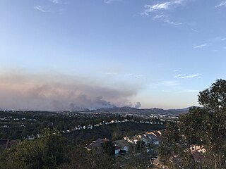
The Silverado Fire was a wildfire that burned in October and November 2020 in southern Orange County, California northeast of the city of Irvine. The fire started on October 26 around 6:47 AM near Orange County Route S-18 and Silverado Canyon Road, fueled by strong Santa Ana winds gusting up to 80 miles per hour (130 km/h) and low humidity. The fire initially moved south from Loma Ridge toward the Orchard Hills, Northwood and Portola Springs communities of Irvine before moving southeast through Limestone Canyon and toward the communities of Foothill Ranch and Lake Forest. The fire burned in a path similar to that taken by the 2007 Santiago Fire, mostly through terrain that had not seen significant burning in the 13 years since that fire. Authorities announced 100% containment on November 7, 2020.

The River Fire was a destructive 2021 wildfire that burned 2,619 acres (1,060 ha) near Colfax in Nevada County and Placer County, California. The fire broke out on August 4, 2021, and burned 2,619 acres (1,060 ha) before it was fully contained on August 13, 2021. The River Fire destroyed 142 structures, damaged 21 more, and resulted in four injuries to firefighters and civilians. It was the fifth most destructive fire of California's 2021 wildfire season. The exact cause of the fire is unknown, but it was determined to have been of human origin by investigators who traced the ignition to a campground by the Bear River west of Colfax.

The 2020 Maricopa County wildfires were a series of major and non-major wildfires that took place in Maricopa County, Arizona, from the month of May to the month of October. In the year 2020, Arizona saw one of its worst fire seasons in the states history. Due to the lack of precipitation needed in Arizona, the state fell into an ongoing drought from late 2020 and 2021. High winds were also present during the summer when fire season is mostly active in the state. These factors led to the wildfires in Maricopa County to be destructive and costly.

On December 15, 2021, the Midwestern U.S. state of Kansas was met with strong and damaging winds caused by the December 2021 Midwest derecho and tornado outbreak, which produced dust storms and multiple wildfires. An estimated 163,000 acres (66,000 ha) burned on the first day wildfires spawned due to dry fuel and strong wind gusts reaching up to 100 mph (160 km/h). The western and central portions of Kansas were mostly affected by the fires. Before December 15, forecasters had predicted that dry air, gusty winds, and warm temperatures could be present throughout the following days, creating conditions favorable for wildfires to spread quickly through the area. The largest wildfire, the Four County Fire, burned numerous buildings and killed hundreds of cattle along the way with a scorched area of 121,622 acres (49,219 ha).

The Fawn Fire was a destructive wildfire in Northern California's Shasta County, near Redding, in late September and early October 2021. The fire, which was caused by an alleged act of arson, ignited on September 22 in mountains to the northeast of Redding. High winds the following day drove the fire south and west into neighborhoods in the wildland-urban interface, where it destroyed 185 buildings and damaged 26 more. At least three firefighters were injured. The Fawn Fire cost more than $25 million to suppress and burned 8,578 acres before being fully contained on October 2. A woman was arrested the day of the Fawn Fire's ignition and charged with starting the fire. As of 2024, legal proceedings remained ongoing.

The 49er Fire was a destructive wildfire in 1988 in Northern California's Nevada County and Yuba County. The fire ignited on September 11 when a man accidentally set brush on fire by burning toilet paper near Highway 49. Driven by severe drought conditions and strong, dry winds, firefighting crews were hard-pressed to stop the fire's advance until winds calmed and humidity levels recovered. The fire burned 33,700 acres throughout the foothills of the Sierra Nevada, impinging on the communities of Lake Wildwood, Rough and Ready, and Smartsville before officials declared it fully contained on September 16.
References
- ↑ USA Today (3 August 2012). "Wildfires burn Okla.; one suspected as arson". Tucson Citizen. Retrieved 5 August 2012.[ permanent dead link ]
- 1 2 "52,000 acres burn in Oklahoma wildfires". UPI. 5 August 2012. Retrieved 5 August 2012.
- 1 2 "Towns' residents flee Oklahoma wildfires that have destroyed dozens of homes". NBC News. 4 August 2012. Retrieved 5 August 2012.
- ↑ "Current U.S. Drought Monitor". University of Nebraska-Lincoln. Retrieved 5 August 2012.
- ↑ "Study by 'global warming godfather': Texas drought, Europe heat waves are climate change". The Washington Post. Associated Press. 4 August 2012. Retrieved 5 August 2012.[ dead link ]
- ↑ "Raging Oklahoma wildfires prompt evacuations". Fox News. 5 August 2012. Retrieved 5 August 2012.
- ↑ "Oklahoma Governor Declares State of Emergency Due to Drought". News 9 Oklahoma. 30 July 2012. Retrieved 5 August 2012.
- 1 2 3 "Oklahoma Wildfires Denial." Federal Emergency Management Agency. October 15, 2012. Accessed November 16, 2017.
- ↑ "Wildfire scorches secluded area near railroad tracks". Durant Daily Democrat. 29 November 2012. Archived from the original on 21 January 2013. Retrieved 30 November 2012.
- ↑ "Drought losses in Oklahoma top $400 million for 2012". CattleNetwork. 29 November 2012. Archived from the original on 31 December 2014. Retrieved 30 November 2012.
- 1 2 3 Ahrens, Tim. "Glencoe firefighter recalls 2012 blaze." Stillwater News Press.April 2, 2016. Accessed November 19, 2017.
- ↑ "Pipeline Companies Ordered to Pay $6.5 M in Damages from Oklahoma Wildfire." Insurance Journal. February 29, 2016. Accessed November 19, 2017.
- 1 2 "Oklahoma fires force more evacuations." Pioneer Press. August 4, 2012, updated November 10, 2015. Accessed November 20, 2017.
- ↑ Associated Press. "Oklahoma wildfire leaves dozens homeless; Dental records sought to ID 1 body found." (CBS News.) August 7, 2016. Accessed November 20, 2017.