
The 1976 Guatemala earthquake struck on February 4 at with a moment magnitude of 7.5. The shock was centered on the Motagua Fault, about 160 km northeast of Guatemala City at a depth of 5 kilometers (3.1 mi) near the town of Los Amates in the department of Izabal.

The Motagua Fault is a major, active left lateral-moving transform fault which cuts across Guatemala. It forms part of the tectonic boundary between the North American plate and the Caribbean plate. It is considered the onshore continuation of the Swan Islands Transform Fault and Cayman trench, which run under the Caribbean Sea. Its western end appears not to continue further than its surface trace, where it is covered by Cenozoic volcanics.
The 2009 Swan Islands earthquake occurred on May 28 at with a moment magnitude of 7.3 and a maximum Mercalli intensity of VII. The epicenter was located in the Caribbean Sea, 64 kilometres (40 mi) northeast of the island of Roatán, 19 miles northeast of Port Royal, Isla de Bahias, 15 miles northwest of Isla Barbaretta, and 130 kilometres (81 mi) north-northeast of La Ceiba. Three aftershocks followed the earthquake within magnitude 4 range.
The 1999 Oaxaca earthquake occurred on September 30 at 11:31 local time in Oaxaca, Mexico, 60 km NNW of Puerto Ángel. The epicenter was located near San Agustin Loxicha. It had a magnitude of 7.4.
The 1982 El Salvador earthquake occurred southeast of San Salvador on 19 June at 00:21 local time. This undersea earthquake struck offshore in the Pacific Ocean and had a surface wave magnitude of 7.3 and a maximum Mercalli intensity of VII. Occurring adjacent to a subduction zone at the Middle America Trench, this normal-slip shock left at least 16 and as many as 43 people dead, and many injured, and also inflicted $5 million in damage.
The 2011 Guerrero earthquake struck with a moment magnitude of 5.7 in southern Mexico at on 5 May. It was positioned west of Ometepec, Guerrero, with a focal depth of 24 km (14.9 mi), and was lightly felt in many adjacent areas.
The 2012 Guerrero–Oaxaca earthquake struck southern Mexico with a moment magnitude of 7.4 at on Tuesday, 20 March. Its epicenter was near Ometepec, in the border between the states of Guerrero and Oaxaca. With a shallow focus of 20 km, the earthquake caused strong shaking over a large area along the Oaxaca–Guerrero border and the adjacent Pacific coastline. Significant tremors were felt in areas up to several hundred kilometers away, including Mexico City and also in Guatemala. Two people were killed and over 30,000 houses were damaged or destroyed.
The 2012 Costa Rica earthquake occurred at 08:42 local time on September 5. The epicenter of the 7.6 Mw earthquake was in the Nicoya Peninsula, 11 kilometers east-southeast of Nicoya. A tsunami warning was issued shortly afterwards, but later cancelled. Two people are known to have died, one from a heart attack and another, a construction worker, crushed by a collapsing wall. It was the second strongest earthquake recorded in Costa Rica's history, following the 1991 Limon earthquake.
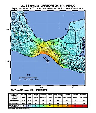
The 2017 Chiapas earthquake struck at 23:49 CDT on 7 September in the Gulf of Tehuantepec off the southern coast of Mexico near the state of Chiapas, approximately 87 kilometres (54 mi) southwest of Pijijiapan, with a Mercalli intensity of IX (Violent). The moment magnitude was estimated to be 8.2.

The 2017 Guatemala earthquake struck near the city of Malacatán in the San Marcos Department, near the Guatemala–Mexico border at 1:29 am local time (UTC−06:00) on June 14. The earthquake killed five people, and caused 30 injuries, 11 of which were from Chiapas, Mexico across the border. No tsunami warning was issued.
The 2021 Assam earthquake struck 11 km away from Dhekiajuli, Assam, India at 07:51 (IST) on April 28, 2021 with a moment magnitude of 6.0 at 34.0 km (21.1 mi) depth. The quake struck with an epicenter 140 km north of the main city of Guwahati. It resulted in two fatalities and at least 12 injuries.
On 9 July 2019, at 8:36 PM (PST), an earthquake measuring 5.6 jolted the province of North Cotabato, Davao del Sur, and other nearby provinces. The National Disaster Risk Reduction and Management Council reported one dead and three injured in Makilala after the earthquake, and a total of 164 families affected in Cotabato Province. Near the epicenter of the earthquake, the severity of strong ground motion was assigned VI (Strong) on the Modified Mercalli intensity scale. A total of 106 schools, 119 houses, and 14 other infrastructures were damaged by the earthquake.
On February 7, 2021, at 12:22 PM PST, an earthquake measuring Mww 6.0 struck Davao del Sur and Cotabato. The event registered a Modified Mercalli Intensity Scale (MMI) of VIII (Severe) with VII on the PHIVOLCS Earthquake Intensity Scale (PEIS).
The 2010 Aguas Buenas earthquake, also referred to as the 2010 Christmas Eve earthquake, occurred on December 24 at 7:43 p.m. local time in Aguas Buenas, Puerto Rico. It measured 5.1 on the moment magnitude scale and had a maximum Mercalli intensity of VI (Strong). The event was the largest in Puerto Rico since May 16th of the same year, and the largest to impact the San Juan metropolitan area since 1975. The earthquake was felt throughout the island of Puerto Rico, the island municipalities of Vieques and Culebra, the American and British Virgin Islands, and even in the Dominican Republic across the Mona Passage.
The 1959 Coatzacoalcos earthquake occurred at 02:25 local time on August 26 near the Mexican state of Veracruz. The earthquake measured 6.4 Mw at a depth of 21 km (13 mi), and had a maximum Modified Mercalli intensity of VIII (Severe). It had an epicenter immediately off the coast of Coatzacoalcos. The shallow back-arc thrust faulting earthquake damaged the cities of Acayucan, Coatzacoalcos, Jáltipan and Minatitlán. A total of 25 people died, including 10 from Jáltipan while a further 200 were injured. The Middle America Trench, a subduction zone that borders the southwestern coast of Mexico and Central America, accounts for much of the seismicity in Mexico. The eastern side of the country near the Gulf of Mexico rarely experiences large earthquakes although they have been recorded around the Veracruz area, where seismicity is higher compared to other parts of the gulf. Seismicity in the gulf is attributed to back-arc compression due to subduction.
The 2012 Constitución earthquake was recorded on March 25, 2012, at 7:37 pm local time. It had a moment magnitude of 7.1 and its epicenter was located 23 km (14 mi) northeast of the city of Constitución, in the Maule Region, Chile. According to experts, it was a strong and late aftershock of the Great Chile earthquake of February 27, 2010.
The 1955 Lanao earthquake struck Lanao del Sur on April 1 at 02:17 local time. The earthquake measuring 7.4 on the moment magnitude scale and assigned a maximum intensity of VIII (Severe) on the Modified Mercalli intensity scale was one of the largest to hit Mindanao. It caused immense damage around the northern and central parts of Mindanao, as well as the southern reaches of Visayas. It killed at least 465 individuals and injured a further 898.

On 19 September 2022, a moment magnitude 7.6–7.7 earthquake struck between the Mexican states of Michoacán and Colima at 13:05:06 local time. The earthquake had a depth of 26.9 km (16.7 mi), resulting in a maximum intensity of VIII (Severe) on the Modified Mercalli intensity scale. The USGS reported the epicentre was 35 km (22 mi) southwest of the town of Aquila. Two people were killed and at least 35 others were injured across several states. A magnitude 6.8 aftershock struck on 22 September, causing three more deaths.
The 1991 Guatemala earthquake occurred on September 18 at 3:48 a.m. local time. The epicenter was 60 miles southwest of Guatemala City. The shock was assigned a magnitude of 5.3 on the Richter scale, later assigned with a magnitude of 6.2. It caused 25 deaths, over 200 injuries and left 1,000 people without homes.


