| |||||
| Decades: | |||||
|---|---|---|---|---|---|
| See also: | |||||

This article is about events in the year 2022 in Madagascar
| |||||
| Decades: | |||||
|---|---|---|---|---|---|
| See also: | |||||
This article is about events in the year 2022 in Madagascar
Ongoing – COVID-19 pandemic in Madagascar; 2021–2022 Madagascar famine; 2022 Africa floods

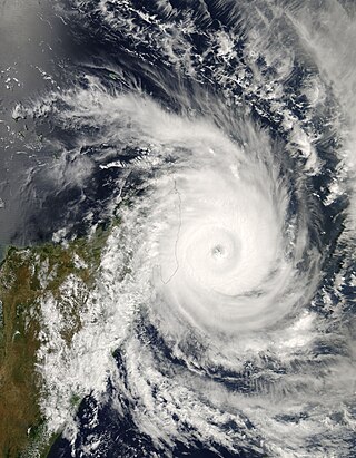
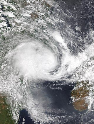
Intense Tropical Cyclone Leon–Eline was the second longest-lived cyclone in the Indian Ocean, behind Cyclone Freddy, traveling over 11,000 km (6,800 mi) during its 29-day track through the Indian Ocean, throughout the month of February. The cyclone formed on 1 February 2000, in the Australian basin as Tropical Cyclone Leon, and was renamed Eline after crossing 90° E into the South-West Indian Ocean; there, the Météo-France office in Réunion (MFR) tracked the storm's movement and intensity. Late on 17 February, Eline made landfall near Mahanoro, Madagascar, with 10‑minute winds of 165 km/h (103 mph). The storm rapidly weakened over land, but restrengthened in the Mozambique Channel to reach peak 10‑minute winds of 185 km/h (115 mph), making it an intense tropical cyclone. On 22 February, Eline made landfall about 80 km (50 mi) south of Beira, Mozambique, near peak intensity. Eline quickly weakened over land as it moved across Southern Africa, finally dissipating over eastern Namibia on 29 February.

The 1999–2000 South-West Indian Ocean tropical cyclone season was the first on record in which two storms – Leon–Eline and Hudah – struck Mozambique at tropical cyclone intensity, or with maximum sustained winds of at least 120 km/h (75 mph). The most notable storm of the season was Eline, which was the third longest-lasting storm on record in the basin. It lasted for 29 days while traversing the southern Indian Ocean, making the strongest landfall in decades along eastern Madagascar in late February. The storm was the first in a series of three storms that struck the country in early 2000, along with Gloria in March and Hudah in April. Collectively, the three storms killed at least 316 people. The season started on November 1, 1999, and ended for most of the basin on April 30, 2000; for Mauritius and the Seychelles, the season continued until May 15. These dates conventionally delimit the period of each year when most tropical cyclones form in the basin.

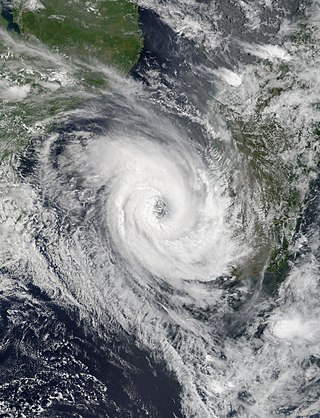
Tropical Cyclone Elita was an unusual tropical cyclone that made landfall on Madagascar three times. The fifth named storm of the 2003–04 South-West Indian Ocean cyclone season, Elita developed in the Mozambique Channel on January 24, 2004. It strengthened to tropical cyclone status before striking northwestern Madagascar on January 28; it was the first storm to strike western Madagascar at that intensity since Cyclone Cynthia in 1991. Elita weakened to tropical depression status while crossing the island, and after exiting into the southwest Indian Ocean, it turned to the west and moved ashore in eastern Madagascar on January 31. After once again crossing the island, the cyclone reached the Mozambique Channel and re-intensified. Elita turned to the southeast to make its final landfall on February 3 along southwestern Madagascar. Two days later, it underwent an extratropical transition; subsequently, the remnant system moved erratically before dissipating on February 13.
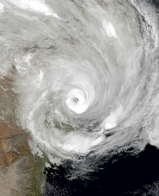
Intense Tropical Cyclone Indlala was a powerful tropical cyclone that struck northeastern Madagascar in March 2007. The ninth named storm and fifth intense tropical cyclone of the 2006–07 South-West Indian Ocean cyclone season, Indlala developed on 3 March 2007 southwest of the Chagos archipelago in the central Indian Ocean. Initially a tropical disturbance, Indlala moved generally westward in its formative stages, attaining tropical cyclone status on 13 March. A day later, the Météo-France office on Réunion (MFR) estimated peak 10–minute sustained winds of 175 km/h (110 mph), although the American-based Joint Typhoon Warning Center estimated stronger 1–minute winds of 220 km/h (135 mph). Early on 15 March, the cyclone made landfall in northeastern Madagascar on the Masoala Peninsula near Antalaha, still at its peak intensity according to the MFR. Indlala rapidly weakened over land and turned southward, eventually re-emerging into the Indian Ocean on 18 March; it was last noted by the MFR on 19 March.

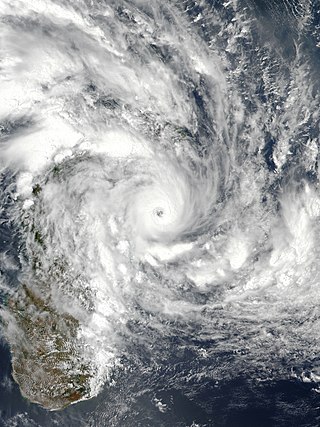
Intense Tropical Cyclone Geralda was a powerful tropical cyclone that caused catastrophic damage in Madagascar in late January 1994, among the strongest to hit the country. It was also the most intense tropical cyclone worldwide in 1994. Cyclone Geralda originated from an area of low pressure over the Indian Ocean on 25 January. Over the following few days, the depression underwent gradual intensification, reaching its peak intensity with ten-minute sustained winds of 205 km/h (127 mph) on 31 January. It eventually made landfall near Toamasina, Madagascar after weakening from its peak intensity, and substantially weakened within hours of moving onshore. By 5 February, Geralda had degenerated into a land depression, and became extratropical three days later. Geralda's remnants dissipated on 12 February.

Intense Tropical Cyclone Giovanna was a powerful tropical cyclone that affected Madagascar. Giovanna was the ninth tropical depression, seventh named storm, and third tropical cyclone of the 2011–12 South-West Indian Ocean cyclone season. Giovanna was blamed for 35 deaths along the Madagascar coast, La Réunion, and Mauritius, and it was the first intense tropical cyclone to impact Madagascar since Cyclone Bingiza one year earlier.
Tropical Cyclone Haruna was a deadly storm that produced widespread flooding and a disease outbreak in southwestern Madagascar. The ninth system of the season, Haruna developed in the Mozambique Channel in the middle of February 2013 between Mozambique and southwestern Madagascar. Initially moving northward over Mozambique, the disturbance later moved slowly southward, gradually strengthening into the eighth named storm of the season and later into an intense tropical cyclone. The Météo-France office in Réunion (MFR) – the official Regional Specialized Meteorological Center in the basin – estimated the cyclone attained peak 10 minute sustained winds of 150 km/h (95 mph). Haruna made landfall near Morombe in southwestern Madagascar on February 22. It weakened significantly while crossing the country, and MFR discontinued advisories on February 24 after the storm had emerged into the Indian Ocean.

In early 2000, severe flooding occurred in the African nation of Madagascar after Cyclone Leon–Eline and Severe Tropical Storm Gloria struck the nation within a two-week period. The first storm, Eline, formed on February 1, and took an extended track across the Indian Ocean, eventually making landfall near Mahanoro on February 17. On March 1, Gloria struck northeastern Madagascar, and like Eline, moved southwestward across the country.

Tropical Cyclone Honorinina was a powerful tropical cyclone that struck eastern Madagascar in March 1986. The eighth named storm of the season, Honorinina formed on 9 March to the south of Diego Garcia. It moved generally to the west-southwest due to a ridge to the south, gradually intensifying. On 12 March, the Météo France office in Réunion (MFR) upgraded Honorinina to tropical cyclone status, which is the equivalent of a minimal hurricane. On the next day, the cyclone attained maximum sustained winds of 150 km/h (93 mph) while in the vicinity of Tromelin Island. Honorinina weakened subsequently before making landfall about 40 km (25 mi) north of Toamasina, Madagascar with winds of 135 km/h (84 mph). The storm weakened further over land, moving southwestward across the country. It emerged into the Mozambique Channel and became extratropical on 18 March. Honorinina then turned to the southeast, dissipating on 23 March.
Tropical Cyclone Ava was a strong tropical cyclone that brought devastating impacts to parts of eastern Madagascar in January 2018. The first tropical depression, first named storm, and first tropical cyclone of the 2017–18 South-West Indian Ocean cyclone season, Ava formed as a weak area of disturbed weather well northeast of St. Brandon on December 30. Monitored by Météo-France La Réunion (MFR), the disturbance drifted southwest, before intensifying to a moderate tropical storm on January 2. Ava drifted south afterwards with little change in strength; then among favorable conditions near the coast of Madagascar Ava rapidly intensified to tropical cyclone intensity by early on January 5 shortly before making landfall in eastern Madagascar. After landfall, Ava pummeled the region with rainfall and flooding as it weakens into a moderate tropical storm. Ava exited the landmass on January 7 and became post-tropical southeast of southern Madagascar on January 8, slowly drifting southwards as a vigorous low before dissipating a day later.

At least 30 tropical cyclones have affected the Southern African mainland. Three southeastern African countries border the Indian Ocean – Tanzania, Mozambique, and South Africa. Other inland countries also experience the effects of tropical cyclones, including Botswana, Eswatini, Lesotho, Malawi, Namibia, Zambia, and Zimbabwe.

Severe Tropical Storm Chalane was the first of three consecutive tropical cyclones that struck Mozambique in the 2020-21 South-West Indian Ocean cyclone season. As the fourth tropical depression, third named storm, and second severe tropical storm of the season, Chalane developed out of a zone of disturbed weather which was first monitored RSMC La Réunion on 19 December. Despite conditions slowly becoming unfavorable, the system formed into a tropical depression on 23 December due to the presence of a Kelvin wave and an equatorial Rossby wave, as well as warm sea surface temperatures. The depression soon strengthened into Tropical Storm Chalane on the following day. Chalane made landfall on Madagascar on 26 December and weakened, before emerging into the Mozambique Channel a couple days later. Subsequently, Chalane restrengthened, before making landfall on Mozambique on 30 December. The system weakened as it moved inland, degenerating into a remnant low later that day. However, Chalane's remnants continued moving westward for another several days, emerging into the South Atlantic on 3 January, before dissipating later that day.
Tropical Cyclone Eloise was the strongest tropical cyclone to impact the country of Mozambique since Cyclone Kenneth in 2019 and the second of three consecutive tropical cyclones to impact Mozambique in the 2020–21 South-West Indian Ocean cyclone season. The seventh tropical depression, fifth named storm and the second tropical cyclone of the season, Eloise's origins can be traced to a disturbance over the central portion of the South-West Indian Ocean basin which developed into a tropical depression on 16 January, and strengthened into a tropical storm on 17 January, though the storm had limited strength and organization. On the next day, the storm entered a more favorable environment, and it soon intensified to a severe tropical storm on 18 January. Late on 19 January, Eloise made landfall in northern Madagascar as a moderate tropical storm, bringing with it heavy rainfall and flooding. The storm traversed Madagascar and entered the Mozambique Channel in the early hours of 21 January. After moving southwestward across the Mozambique Channel for an additional 2 days, Eloise strengthened into a Category 1-equivalent cyclone, due to low wind shear and high sea surface temperatures. Early on 23 January, Eloise peaked as a Category 2-equivalent tropical cyclone on the Saffir–Simpson scale as the center of the storm began to move ashore in Mozambique. Shortly afterward, Eloise made landfall just north of Beira, Mozambique, before rapidly weakening. Subsequently, Eloise weakened into a remnant low over land on 25 January, dissipating soon afterward.

During 2022, tropical cyclones formed in seven major bodies of water, commonly known as tropical cyclone basins. Tropical cyclones were named by various weather agencies when they attained maximum sustained winds of 35 knots. During the year, 133 systems formed, of which 87 were named. The strongest storm to form was Typhoon Nanmadol, with minimum pressure of 910 hPa (26.87 inHg). The deadliest tropical cyclone was Tropical Storm Megi, which caused 214 fatalities in the Philippines, while the costliest was Hurricane Ian, which had an estimated damage total of at least $113.1 billion after affecting Trinidad and Tobago, Venezuela, Colombia, the western part of the Greater Antilles and Southeast United States.

The 2021–22 South-West Indian Ocean cyclone season featured the record latest start for the first system to develop. Despite the late start, it was an above-average season that produced 12 named storms, with five becoming tropical cyclones. The season began on 15 November 2021, and ended on 30 April 2022, with the exception for Mauritius and the Seychelles, for which it ended on 15 May 2022. These dates conventionally delimit the period of each year when most tropical and subtropical cyclones form in the basin, which is west of 90°E and south of the Equator. However, tropical cyclones that form at any time between July 1st, 2021 and June 30th, 2022 will count towards the season total. Tropical and subtropical cyclones in this basin are monitored by the Regional Specialised Meteorological Centre in Réunion and unofficially by the Joint Typhoon Warning Center.
Severe Tropical Storm Ana was a deadly tropical cyclone that affected the African nations of Madagascar, Malawi and Mozambique and was the third-deadliest tropical cyclone in 2022, after the Western Pacific Tropical Storm Megi and Atlantic Hurricane Ian. The first named storm of the 2021–22 South-West Indian Ocean cyclone season, Ana developed from an area of convection that was designated as Invest 93S northeast of Madagascar.

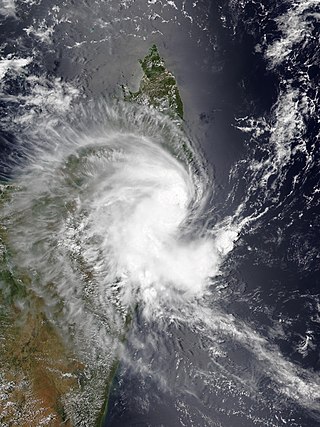
Intense Tropical Cyclone Batsirai was a deadly tropical cyclone which heavily impacted Madagascar in February 2022, becoming the strongest tropical cyclone to strike Madagascar since Cyclone Enawo in 2017. It made landfall two weeks after Tropical Storm Ana brought deadly floods to the island country in late January. The second tropical disturbance, the first tropical cyclone, and the first intense tropical cyclone of the 2021–22 South-West Indian Ocean cyclone season, Batsirai originated from a tropical disturbance that was first noted on 24 January 2022. It fluctuated in intensity and became a moderate tropical storm on 27 January 2022, after which it unexpectedly rapidly intensified into an intense tropical cyclone. It then weakened and struggled to intensify through the coming days due to present wind shear and dry air, where it weakened after some time. Afterward, it entered much more favorable conditions, rapidly intensified yet again to a high-end Category 4 cyclone on the Saffir–Simpson scale while moving towards Madagascar. The storm underwent an eyewall replacement cycle the next day, and fluctuated in intensity before making landfall in Madagascar as a Category 3 cyclone, later rapidly weakening due to the mountainous terrain on the island.

Throughout 2022, floods affected most of Africa, killing over 2,100 people. The worst affected country was Nigeria, with over 610 deaths.

Intense Tropical Cyclone Emnati was a tropical cyclone that affected Madagascar, only two weeks after Cyclone Batsirai. The sixth tropical disturbance, the second tropical cyclone, and the second intense tropical cyclone of the 2021–22 South-West Indian Ocean cyclone season, Emnati formed from a zone of disturbed weather that was first noted on 15 February 2022. It continued westward, and steadily intensified before getting named Emnati a day later. Due to present dry air and wind shear, the storm had struggled to intensify significantly, and it became a category 1-equivalent on the Saffir-Simpson Scale later. After it managed to close off its core from prohibiting factors, the storm quickly intensified into a category 4-equivalent days later, forming a small eye around its CDO. Emnati then underwent a lengthy eyewall replacement cycle, which strongly weakened the storm as it moved closer to Madagascar. Eventually, it weakened back to a category 1-equivalent cyclone before making landfall in the country.
Moderate Tropical Storm Dumako was a weak tropical cyclone that caused moderate damage in Madagascar. The fourth disturbance and fourth named storm of the 2021–22 South-West Indian Ocean cyclone season, it was the third storm to make landfall on Madagascar in 2022 after Ana and Batsirai.
|