Related Research Articles
Calgary Transit is the public transit agency which is owned and operated by the city of Calgary, Alberta, Canada. In 2019, an estimated 106.5 million passengers boarded approximately 1,155 Calgary Transit vehicles. It operates light metro (LRT), urban tramway, bus rapid transit (BRT), para-transit, and regular bus services. In 2022, the system had a ridership of 103,306,500, or about 389,000 per weekday as of the fourth quarter of 2022.
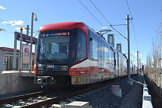
CTrain is a light rail rapid transit system in Calgary, Alberta, Canada. Much of the system functions as a high-capacity light metro, while in the downtown free-fare zone, trains transition into a tram with a dedicated right-of-way. The CTrain began operation on May 25, 1981 and has expanded as the city has increased in population. The system is operated by Calgary Transit, as part of the Calgary municipal government's transportation department. In 2022, the system had a ridership of 61,889,500, or about 228,800 per weekday as of the fourth quarter of 2022, making it one of the busiest light rail transit systems in North America. Approximately 45% of workers in Downtown Calgary take the CTrain to work.

Beltline is a region of central Calgary, Alberta, Canada. The area is located immediately to the south of Calgary's downtown, and is sometimes considered part of downtown. The neighbourhood is bounded on the south by 17th Avenue, on the west by 14th Street West and on the east by the Elbow River. Beltline is one of Calgary's most densely populated neighbourhoods as well as the most urban, featuring many apartments, condominiums and offices. It has the reputation of being one of Calgary's primary areas for eclectic night-life, restaurants and urban culture.

Inglewood is an urban neighbourhood in central Calgary, Alberta, Canada, centred on 9th Avenue SE for several blocks east of the Elbow River and downtown. It also contains the Business Revitalization Zone of Inglewood.

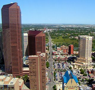
Downtown Calgary is a dense urban district in central Calgary, Alberta. It contains the second largest concentration of head offices in Canada, despite only being the country's fourth largest city in terms of population. The downtown is divided into several residential, commercial, corporate, and mixed-use neighbourhoods, including the Financial District (CBD), Eau Claire, Chinatown, East Village, Beltline, and the West End.

Downtown Edmonton is the central business district of Edmonton, Alberta. Located at the geographical centre of the city, the downtown area is bounded by 109 Street to the west, 105 Avenue to the north, 97 Street to the east, 97 Avenue and Rossdale Road to the south, and the North Saskatchewan River to the southeast.

Transit City was a plan for developing public transport in Toronto, Ontario, Canada. It was first proposed and announced on 16 March 2007 by then-Toronto Mayor David Miller and Chair of the Toronto Transit Commission (TTC) Adam Giambrone. The plan called for the construction of seven new light rail lines along the streets of seven priority transit corridors, which would have eventually been integrated with existing rapid transit, streetcar, and bus routes. Other transit improvements outlined in the plan included upgrading and extending the Scarborough RT line, implementing new bus rapid transit lines, and improving frequency and timing of 21 key bus routes. The plan integrated public transportation objectives outlined in the City of Toronto Official Plan, the TTC Ridership Growth Strategy and Miller's 2006 election platform.
Tuxedo Park is a residential neighbourhood in the northeast and northwest quadrants of Calgary, Alberta. The inner city community is bounded to the north by 32 Avenue N, by Edmonton Trail to the east, the Trans-Canada Highway to the south and 2 Street NW to the west. The community is bisected by Centre Street from north to south.
Centre Street is a major road in Calgary, Alberta, and defines the east and west halves of the city for the purposes of street addresses.
The Blue Line, also known as Route 202, is a light rail transit (LRT) line in Calgary, Alberta, Canada. Partnered with the Red Line, and future Green Line it makes up Calgary's CTrain network. Following its initial approval in 1976, the Red Line opened in 1981, with the first trains running on what is now the Blue Line in 1985.

The Red Line, also known as Route 201, is a light rail transit (LRT) line in Calgary, Alberta, Canada. Partnered with the Blue Line, and future Green Line it makes up Calgary's CTrain network. Following its initial approval in 1976, the Red Line opened in 1981, running from Anderson station in the southeast into downtown. The Red Line has gone through a series of expansions, which bring it to its current design. The Red Line services the northwest quadrant and south end of the city beginning at Tuscany station, runs through the downtown core on 7th Avenue, then proceeds southbound where it terminates at Somerset–Bridlewood station. The section of track running along 7th Avenue is shared with the Blue Line. Future expansion of the Red Line includes rerouting the downtown section below 8th Avenue, which would allow the operation of five-car trains, further increasing capacity.
The Green Line is a light rail (LRT) line under construction in Calgary, Alberta, Canada. The line will run between Calgary’s north-central and southeastern boundaries, connecting with the Red Line and Blue Line in the city’s downtown. The Green Line is the largest public infrastructure project in Calgary's history and will be the first rail line in the city to operate low-floor trains. When completed, the Green Line will comprise 29 stations spanning 46 kilometres (29 mi). This will bring the total number of CTrain stations in Calgary to 74.

MAX Purple, also known as Route 307 or the 17 Avenue SE BRT, is a bus rapid transit line in Calgary, Alberta. Part of Calgary Transit's MAX network, it largely travels east along 17 Avenue SE from downtown Calgary.
16 Avenue North is a planned and approved CTrain light rail station in Calgary, Alberta, Canada part of the Green Line. Construction is expected to begin in 2024 and complete in 2027 as part of construction stage one, phase two. The station serves as the northern terminus station for stage one of construction and is expected to be one of the busiest stations on opening day. It will serve as a transfer point between the Green Line and MAX Orange BRT, connecting riders to the city's northwest, northeast, the Southern Alberta Institute of Technology, the University of Calgary, the Foothills Medical Centre, the Alberta Children's Hospital and future Calgary Cancer Centre.
9 Avenue North is a planned and approved CTrain light rail station in Calgary, Alberta, Canada part of the Green Line. Construction is expected to begin in 2024 and complete in 2027 as part of construction stage one, phase two.
Eau Claire is a planned and approved CTrain light rail station in Calgary, Alberta, Canada part of the Green Line. Construction is expected to begin in 2022 and complete in 2027 as the northern terminus of construction phase one. The station is named for and located in the high density urban community of Eau Claire, immediately north of downtown Calgary.
Centre Street South is a planned and approved CTrain light rail station in Calgary, Alberta, Canada part of the Green Line. Construction will begin in 2023 and complete in 2027 as part of construction stage one, segment 2A. The station is located in the Beltline, immediately south of downtown Calgary.
4 Street Southeast is a planned and approved CTrain light rail station in Calgary, Alberta, Canada part of the Green Line. Construction will begin in 2023 and complete in 2027 as part of construction stage one, segment 2A. The station is located in Beltline, immediately southeast of downtown Calgary near the confluence of the Bow River and Elbow River.
26 Avenue SE is a planned and approved CTrain light rail station in Calgary, Alberta, Canada part of the Green Line. Construction will begin in 2022 and complete in 2027 as part of construction stage one, segment one. The station is located in Alyth/Bonnybrook/Manchester near Barlow Trail.
Ogden is a planned and approved CTrain light rail station in Calgary, Alberta, Canada part of the Green Line. Construction will begin in 2022 and complete in 2027 as part of construction stage one, segment one. The station is located in the community of Ogden.
References
- ↑ Transportation. "Green Line LRT: Segment 2 (A & B)". www.calgary.ca. Archived from the original on 2020-05-22. Retrieved 2020-07-21.
- ↑ Transportation. "7 Avenue S.W. Green Line Station". www.calgary.ca. Retrieved 2020-07-21.
This article about a railway station in Alberta is a stub. You can help Wikipedia by expanding it. |