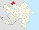
Ağdam Qalal

Last updated

Coordinates: 41°38′41″N46°53′23″E / 41.64472°N 46.88972°E / 41.64472; 46.88972

Geographic coordinate system Coordinate system

A geographic coordinate system is a coordinate system that enables every location on Earth to be specified by a set of numbers, letters or symbols. The coordinates are often chosen such that one of the numbers represents a vertical position and two or three of the numbers represent a horizontal position; alternatively, a geographic position may be expressed in a combined three-dimensional Cartesian vector. A common choice of coordinates is latitude, longitude and elevation. To specify a location on a plane requires a map projection.

Ağdam Qalal
Azerbaijan adm location map.svg
Red pog.svg
Ağdam Qalal
Coordinates: 41°38′41″N46°53′23″E / 41.64472°N 46.88972°E / 41.64472; 46.88972
CountryFlag of Azerbaijan.svg  Azerbaijan
Rayon Zaqatala
Time zone AZT (UTC+4)
  Summer (DST) AZT (UTC+5)

Ağdam Qalal (also, Agdamkelal and Agdamkelyal) is a village in the Zaqatala Rayon of Azerbaijan.

Azerbaijan republic in Western Asia and Eastern Europe

Azerbaijan, officially the Republic of Azerbaijan, is a country in the South Caucasus region of Eurasia at the crossroads of Eastern Europe and Western Asia. It is bounded by the Caspian Sea to the east, Russia to the north, Georgia to the northwest, Armenia to the west and Iran to the south. The exclave of Nakhchivan is bounded by Armenia to the north and east, Iran to the south and west, and has an 11 km long border with Turkey in the northwest.

Related Research Articles

Karadagly, Agdam Place in Agdam, Azerbaijan

Karadagly is a village in the Agdam Rayon of Azerbaijan.

Qurdlar, Agdam Place in Agdam, Azerbaijan

Kürdlər is a village in the Agdam Rayon of Azerbaijan.

Muğanlı, Agdam Place in Agdam, Azerbaijan

Muğanlı is a village in the Agdam Rayon of Azerbaijan.

Şelli Place in Agdam, Azerbaijan

Şelli is a village in the Agdam Rayon of Azerbaijan. Most of the village is ruined following the Battle of Agdam, but unlike the city and the surrounding villages of Agdam, Şelli still has a little population on the southwestern end of the village.

Pərioğlular, Agdam Place in Agdam, Azerbaijan

Pərioğlular is a village in the Agdam Rayon of Azerbaijan.

Çuxurməhlə Place in Agdam, Azerbaijan

Çuxurməhlə is a village in the Agdam Rayon of Azerbaijan.

Daşbaşı, Agdam Place in Agdam, Azerbaijan

Daşbaşı is a village in the Agdam Rayon of Azerbaijan.

Qiyaslı, Agdam Place in Agdam, Azerbaijan

Qiyaslı is a village in the Agdam Rayon of Azerbaijan.

Sırxavənd Place in Agdam

Sırxavənd is a village in the Agdam Rayon of Azerbaijan.

Qazançı, Agdam Place in Agdam, Azerbaijan

Qazançı is a village in the Agdam Rayon of Azerbaijan.

Göytəpə, Agdam Place in Agdam, Azerbaijan

Not to be confused with Geok Tepe in Turkmenistan.

Kosalar, Agdam Place in Agdam, Azerbaijan

Kosalar is a village in the Agdam Rayon of Azerbaijan.

Şotlanlı, Agdam Place in Agdam, Azerbaijan

Şotlanlı is a village in the Agdam Rayon of Azerbaijan.

Qalal, Azerbaijan Place in Zaqatala, Azerbaijan

Qalal is a village in the Zaqatala Rayon of Azerbaijan. The village forms part of the municipality of Əli Bayramlı.

Əhmədavar Place in Agdam, Azerbaijan

Əhmədavar is a village in the Agdam Rayon of Azerbaijan.

Sofulu, Agdam Place in Agdam, Azerbaijan

Sofulu is a village in the Agdam Rayon of Azerbaijan.

Çullu (Chullu Vtoroye), Agdam Place in Agdam, Azerbaijan

Çullu is a village in the Agdam Rayon of Azerbaijan.

Seiser Alm is a Dolomite plateau and the largest high-altitude Alpine meadow in Europe. Located in Italy's South Tyrol province in the Dolomites mountain range, it is a major tourist attraction, notably for skiing and hiking.

Bixiga São Paulo neighborhood in Southeast, Brazil

Bixiga is a neighbourhood at center of the city of São Paulo, Brazil.

Stanford is an unincorporated community in Latah County, in the U.S. state of Idaho.

References