Abu Nakhla

Last updated • 3 min readFrom Wikipedia, The Free Encyclopedia
Abu Nakhla
أبو نخلة
Village
Qatar adm location map.svg
Red pog.svg
Abu Nakhla
Coordinates: 25°09′00″N51°20′00″E / 25.15000°N 51.33333°E / 25.15000; 51.33333 [1]
Country Flag of Qatar.svg Qatar
Municipality Al-Shahaniya
Zone Zone 82

Abu Nakhla (Arabic : أبو نخلة, romanized: Abū Nakhlah) is a district in Qatar, located in the municipality of Al-Shahaniya. [2] Previously a village of some importance stood here, but by the 21st century was largely depopulated. [3] It was recorded as a stand-alone district in zone no. 81 with Al Mukaynis in the 2004 census, but both districts lost their census designations to Mebaireek. [4] In 2014, Abu Nakhla was moved from Al Rayyan Municipality to the newly created Al-Shahaniya Municipality.

Contents

A hospital managed by the Hamad Medical Corporation is based here to meet the health needs for workers of the nearby Doha Industrial Area. [5]

Etymology

"Abu" is the Arabic word for father, and serves to denote a geographical feature. The second word, "nakhla", is the local term for a palm tree, and was chosen in reference to a lone palm tree found in the area. [3]

Geography

Reeds (Phragmites australis) in Abu Nakhla Pond Reeds in Abu Nakhla Pond.jpg
Reeds ( Phragmites australis ) in Abu Nakhla Pond

Situated in central Qatar about 15 kilometres (9.3 mi) away from the capital Doha, the district straddles the border of Al Rayyan Municipality and Al-Shahaniya Municipality. [6]

Abu Nakhla forms part of the western boundary of the southern desert region, which occupies 34.7% of Qatar's total area. Of the four sub-regions of the southern desert, Abu Nakhla is a part of the trapezoidal-shaped hamada sub-group, which has its eastern boundary at Mesaieed, the water pipeline running between the two demarcating the base of this zone. The area around Abu Nakhla is characterized by its rocky surface terrain (hamada), which is distinct from the sand dunes area further south. The surface is covered by a mosaic of closely packed pebbles and rock fragments or, in some places, by a thin layer of indurated mineral deposits forming a hard crust. [7]

Abu Nakhla Pond

Since 1985, sewage effluent from Doha has been dumped in a depression (rawda) in Abu Nakhla. Combined with gradual and continuous rainfall during the rainy season, the depression has morphed into a 2 to 3 km pond. Locals have long complained about negative environmental and health effects resulting from the pond, including increased pest populations, foul odors and seepage into aquifers. There is also a strong perception that the sewage water is untreated, and could pose a health hazard. From 2014 to 2015, a study was carried out on the area to investigate potential environmental hazards posed by the pond. [8]

The study revealed that, in regards to lithology, the rocks of the pond comprised two members of the Eocene-period Dammam Formation: the Simsima/Umm Bab Member and the Midra Shale Member. The former member is known for its shallow aquifer, as well as for its weak structure and frequent crevices and fissures, which make it susceptible to contamination by sewage leakage from the pond. Of the water quality, the pond was found to contain low amounts of bacterial contaminants due to Qatar's use of sophisticated filtration techniques. Concentrations of heavy metals were also found to be within acceptable ranges. [8]

Various species of wildlife currently reside in and around the pond, including frogs, fish, and at least 260 bird species. Approximately 150 greater flamingos have been recorded in the area. Plant life is also abundant here; approximately 10% of Qatar's documented plant species are represented here. [8]

Common vegetation found around the pond include cat's tail ( Typha domingensis ) [9] and reeds ( Phragmites australis ). [10]

Attractions

Dilapidated mosque near the water reservoirs in Abu Nakhla. Old mosque in Abu Nakhla.jpg
Dilapidated mosque near the water reservoirs in Abu Nakhla.

Qatar's first water park was opened in Abu Nakhla in October 2010. [11] Cypriot company Aqua Masters was responsible for the park's planning and development while Kuwaiti Al Jazeera Entertainment Enterprises Company oversees its operation. Spread out over a 50,000 m2 area, the park can accommodate up to 3,000 visitors at a time. A 300,000 m2 tourist resort is under development next to the park. [6]

Agriculture

As part of the Ministry of Municipality and Environment's Al Azab program to help improve the healthcare for livestock, it was announced in 2019 that a modern veterinary clinic is planned for the district. [12]

Water reservoir

Abu Nakhla is one of five sites for the government-sponsored project to develop reservoirs in the country. [13] Once completed, the reservoirs are expected to be the largest in the world in their category, [14] with a total length of 650 km and constructed at a cost of QR 14.5 billion. In June 2018, the first phase of the project was completed. [15]

Related Research Articles

<span class="mw-page-title-main">Municipalities of Qatar</span>

Since 2015, Qatar has been divided into eight municipalities. In 2004, a new municipality, Al Daayen, was created under Resolution No. 13, formed from parts of Umm Salal and Al Khawr; at the same time, Al Ghuwariyah was merged with Al Khawr; Al Jumaliyah was merged with Ar Rayyan; Jarayan al Batnah was split between Al Rayyan and Al Wakrah; and Mesaieed was merged with Al Wakrah. In 2014, the western city of Al-Shahaniya split off from Al Rayyan Municipality to form its own municipality.

<span class="mw-page-title-main">Al Rayyan</span> Municipality in Qatar

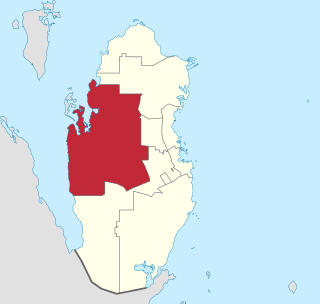
Al Rayyan is the third-largest municipality in the state of Qatar. Its primary settlement is the city of the same name, which occupies the entire eastern section and is a part of the Doha Metropolitan Area. The vast expanse of mostly undeveloped lands in the south-west also falls under the municipality's administration.

<span class="mw-page-title-main">Al Gharrafa</span> District in Al Rayyan, Qatar

Al Gharrafa is a Qatari district of Al Rayyan City, which is located in the municipality of Al Rayyan. In close proximity to Education City and constituting a part of the Doha Metropolitan Area, the Doha Expressway and Al Shamal Highway run along the district. Many malls operate out of the area. To the east, it neighbors the largely residential areas of Duhail and Madinat Khalifa North, therefore Al Gharrafa is largely a retail hub for nearby residential areas. Doha's downtown is 10 kilometres (6.2 mi) to the southeast.

<span class="mw-page-title-main">Al-Shahaniya</span> Municipality in Qatar

Al Shahaniya is a municipality (3299 km2) in Qatar, with its municipal seat being a city of the same name (39 km2). Formerly in the municipality of Al Rayyan, but now an independent municipality, the municipal seat was delimited in 1988 by Law No. 22. In 2014, the cabinet ratified a draft amending provisions to the 1988 law that formalized Al Shahaniya as Qatar's eighth municipality.

<span class="mw-page-title-main">New Al Hitmi</span> District in Ad Dawhah, Qatar

New Al Hitmi is a Qatari district located in the municipality of Ad Dawhah. The name is derived from the Al-Hitmi family, which is a branch of the main Al Bin Ali tribe. Together with Fereej Bin Omran and Hamad Medical City, it forms Zone 37, which has a population of 26,121.

<span class="mw-page-title-main">Dukhan</span> City in Al-Shahaniya Municipality, Qatar

Dukhan is a city in the western municipality of Al-Shahaniya in Qatar. It is approximately 80 kilometres (50 mi) west of the capital, Doha. Dukhan is administered by Qatar's state oil agency QatarEnergy and is the site of the first oil discovery in Qatar. It was previously a part of Al Rayyan municipality.

<span class="mw-page-title-main">Al Karaana</span> Village in Al Rayyan, Qatar

Al Karaana is a Qatari village located in the municipality of Al Rayyan. It used to be part of the Jariyan Al Batnah municipality before the municipality was incorporated into Al Rayyan. It is situated around 60 kilometres (37 mi) to the south-west of the capital Doha.

<span class="mw-page-title-main">Rawdat Rashed</span> Village in Al-Shahaniya, Qatar

Rawdat Rashed is a village in Qatar, located in the municipality of Al-Shahaniya. It was demarcated in 1988. It used to be part of the Jariyan Al Batnah municipality before the municipality was incorporated into Al Rayyan. In 2014, the village was incorporated into the newly created Al-Shahaniya Municipality.

<span class="mw-page-title-main">Mebaireek</span> Settlement in Al Rayyan, Qatar

Mebaireek is a settlement in Qatar, located in the municipality of Al Rayyan. It was formalized as one of Al Rayyan's ten administrative zones in the mid-2000s following the merger of the two census-designated districts of Abu Nakhla and Al Mukaynis. Al Mukaynis, which is known for Mudhlem Cave, is still in Zone 81 with Mebaireek whereas Abu Nakhla has moved to Al-Shahaniya Municipality.

<span class="mw-page-title-main">Al Jemailiya</span> Town in Al-Shahaniya, Qatar

Al Jemailiya is a town in the municipality of Al-Shahaniya, Qatar. It used to be the seat of Al Jemailiya Municipality before it was incorporated into Al Rayyan Municipality in 2004. In 2014, the town was incorporated into the newly created Al-Shahaniya Municipality. The town lies roughly 30 km north-west of the Al-Shahaniya Exit of Dukhan Highway. It has been designated a District Centre for Al-Shahaniya Municipality, meaning that it is being developed to serve the needs of nearby communities, such as Al Suwaihliya.

<span class="mw-page-title-main">Al Messila (Doha)</span> District in Ad-Dawhah, Qatar

Al Messila is a Qatari district in the municipality of Doha. For the most part, large gated compounds and schools occupy this district. It shares its western border with Lebday and Old Al Rayyan in Al Rayyan Municipality.

<span class="mw-page-title-main">Umm Salal Ali</span> Town in Umm Salal, Qatar

Umm Salal Ali is the seat of the municipality of Umm Salal in Qatar.

Umm Birka is a settlement in the Al Khor municipality of Qatar.

<span class="mw-page-title-main">Abu Hamour</span> District in Al Rayyan, Qatar

Abu Hamour is a Qatari district in the municipality of Al Rayyan. Known to some as the "Wholesale Market District", it is a part of the Doha Metropolitan Area.

<span class="mw-page-title-main">Ad-Dawhah (municipality)</span> Municipality in Qatar

Ad-Dawhah is one of the eight municipalities of Qatar. It is the most populous municipality with a population of 1,186,023 in 2020, and is the municipality of Qatar's capital city, Doha.

<span class="mw-page-title-main">Al-Shahaniya (city)</span> City in Al-Shahaniya, Qatar

Al-Shahaniya City is a city in Qatar, located in the similarly named municipality of Al-Shahaniya.

<span class="mw-page-title-main">Al Rayyan (city)</span> City in Al Rayyan, Qatar

Al-Rayyan is a city in the similarly named municipality of Al Rayyan, in Qatar. The city and its suburbs comprise the largest population center in Qatar outside of Doha proper, immediately to its east. Consisting of all of the districts in the municipality's easternmost section, its western boundary is roughly where the Al Majd Highway runs through the municipality. The city is a part of the Doha Metropolitan Area. It was one of the venues for the 2022 FIFA World Cup.

Al Hemaila is a district in Qatar, located in the municipality of Al Rayyan.

Madinat Al Mawater is a planned community of Rawdat Rashed in the Al-Shahaniya Municipality, central Qatar. Its first phase of construction was launched in May 2016. The community will occupy an area of 1.15 km2 and have a developed area of 167,072 m2.

References

  1. "Abū Nakhlah: Qatar". geographic.org. Retrieved 3 January 2019.
  2. "Qatar Development Atlas - Part 1" (PDF). Ministry of Development Planning and Statistics. 2010. p. 10. Archived from the original (PDF) on 18 July 2020. Retrieved 3 January 2019.
  3. 1 2 "District map". The Centre for Geographic Information Systems of Qatar. Archived from the original on 24 November 2020. Retrieved 3 January 2019.
  4. "2004 population census". Ministry of Development Planning and Statistics. Archived from the original on 27 June 2017.
  5. "PEO delivers Ras Laffan Hospital, health centre for workers to HMC". Qatar Tribune. Qatar News Agency. 22 November 2017. Retrieved 26 February 2019.
  6. 1 2 "Aqua Park - Water Themed Park". Online Qatar. Retrieved 26 February 2019.
  7. "طبوغرافية شبه جزيرة قطر" (in Arabic). Qatar Historical Encyclopedia. 28 April 2024. Retrieved 21 July 2024.
  8. 1 2 3 Elnaiem Ali Elobaid; Fadhil Nomas Sadooni; Luc Lebbe; et al. (March 2018). Environmental Evaluation Risk Assessment and Management options of Abu Nakhla Treated Sewage Effluent TSE Unlined Pond - Doha, Qatar. Qatar Foundation Annual Research Conference Proceedings 2018. Hamad Bin Khalifa University Press. Retrieved 26 February 2019.
  9. "Cat's-tail". Qatar e-Nature. Retrieved 21 July 2024.
  10. "Reed". Qatar e-Nature. Retrieved 21 July 2024.
  11. "Aqua Park". Destination Amari. Retrieved 26 February 2019.
  12. Sanaullah Ataullah (7 January 2019). "New veterinary centre to come up in Abu Nakhla". The Peninsula. Retrieved 7 January 2019.
  13. "رئيس الوزراء: يطلق مشروع الخزانات الاستراتيجية الكبرى لتأمين المياه". Qatar Government. 13 May 2015. Retrieved 17 December 2015.
  14. Amery, Hussain A. (15 June 2015). Arab Water Security: Threats and Opportunities in the Gulf States. Cambridge University Press. p. 121. ISBN   9781316381069.
  15. Sanaullah Ataullah (29 June 2018). "PM opens first phase of QR14.5bn reservoirs project". The Peninsula. Retrieved 29 June 2018.