Adair, Illinois Reedyville | |
|---|---|
 Adair  Adair | |
| Coordinates: 40°25′08″N90°29′48″W / 40.41889°N 90.49667°W | |
| Country | United States |
| State | Illinois |
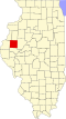
| County | McDonough |
| Township | New Salem |
| Area | |
• Total | 0.43 sq mi (1.11 km2) |
| • Land | 0.43 sq mi (1.11 km2) |
| • Water | 0 sq mi (0.00 km2) |
| Elevation | 646 ft (197 m) |
| Population | |
• Total | 212 |
| • Density | 493.4/sq mi (190.51/km2) |
| Time zone | UTC-6 (Central (CST)) |
| • Summer (DST) | UTC-5 (CDT) |
| ZIP code | 61411 |
| Area code | 309 |
| GNIS feature ID | 2628541 [2] |
Adair is an unincorporated community and census-designated place (CDP) in McDonough County, Illinois, United States. It is part of New Salem Township. As of the 2020 census, Adair had a population of 212. [3]
Contents
Adair was laid out in August 1870 under the name of "Reedyville"; though the name has never been officially changed, the location is known as Adair because that name was given to the post office. [4]
Adair is in eastern McDonough County, along U.S. Route 136 (Main Street). US 136 leads northwest 11 miles (18 km) to Macomb, the county seat, and southeast 28 miles (45 km) to Havana. The Burlington Northern Santa Fe Railway runs through the east side of Adair.