
In physical geography, a dune is a hill of loose sand built by aeolian processes (wind) or the flow of water. Dunes occur in different shapes and sizes, formed by interaction with the flow of air or water. Most kinds of dunes are longer on the stoss (upflow) side, where the sand is pushed up the dune, and have a shorter "slip face" in the lee side. The valley or trough between dunes is called a slack.

A beach is a landform alongside a body of water which consists of loose particles. The particles composing a beach are typically made from rock, such as sand, gravel, shingle, pebbles. The particles can also be biological in origin, such as mollusc shells or coralline algae.

Holkham National Nature Reserve is England's largest national nature reserve (NNR). It is on the Norfolk coast between Burnham Overy Staithe and Blakeney, and is managed by Natural England with the cooperation of the Holkham Estate. Its 3,900 hectares comprise a wide range of habitats, including grazing marsh, woodland, salt marsh, sand dunes and foreshore. The reserve is part of the North Norfolk Coast Site of Special Scientific Interest, and the larger area is additionally protected through Natura 2000, Special Protection Area (SPA) and Ramsar listings, and is part of both an Area of Outstanding Natural Beauty (AONB) and a World Biosphere Reserve. Holkham NNR is important for its wintering wildfowl, especially pink-footed geese, Eurasian wigeon and brant geese, but it also has breeding waders, and attracts many migrating birds in autumn. A number of scarce invertebrates and plants can be found in the dunes, and the reserve is one of the only two sites in the UK to have an antlion colony.

Ammophila is a genus of flowering plants consisting of two or three very similar species of grasses. The common names for these grasses include marram grass, bent grass, and beachgrass. These grasses are found almost exclusively on the first line of coastal sand dunes. Their extensive systems of creeping underground stems or rhizomes allow them to thrive under conditions of shifting sands and high winds, and to help stabilize and prevent coastal erosion. Ammophila species are native to the coasts of the North Atlantic Ocean where they are usually the dominant species on sand dunes. Their native range includes few inland regions, with the Great Lakes of North America being the main exception. The genus name Ammophila originates from the Greek words ἄμμος (ámmos), meaning "sand", and φίλος (philos), meaning "friend".
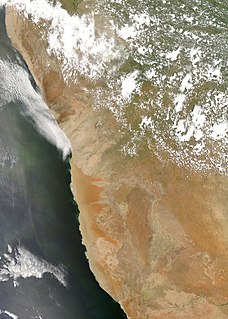
The Namib is a coastal desert in southern Africa. The name Namib is of Khoekhoegowab origin and means "vast place". According to the broadest definition, the Namib stretches for more than 2,000 kilometres (1,200 mi) along the Atlantic coasts of Angola, Namibia, and South Africa, extending southward from the Carunjamba River in Angola, through Namibia and to the Olifants River in Western Cape, South Africa. The Namib's northernmost portion, which extends 450 kilometres (280 mi) from the Angola-Namibia border, is known as Moçâmedes Desert, while its southern portion approaches the neighboring Kalahari Desert. From the Atlantic coast eastward, the Namib gradually ascends in elevation, reaching up to 200 kilometres (120 mi) inland to the foot of the Great Escarpment. Annual precipitation ranges from 2 millimetres (0.079 in) in the most arid regions to 200 millimetres (7.9 in) at the escarpment, making the Namib the only true desert in southern Africa. Having endured arid or semi-arid conditions for roughly 55–80 million years, the Namib may be the oldest desert in the world and contains some of the world's driest regions, with only western South America's Atacama Desert to challenge it for age and aridity benchmarks.

The Oregon Dunes National Recreation Area is located on the Oregon Coast, stretching approximately 40 miles (64 km) north of the Coos River in North Bend to the Siuslaw River in Florence, and adjoining Honeyman State Park on the west. It is part of Siuslaw National Forest and is administered by the United States Forest Service.
NVC community SD18 is one of the 16 sand-dune communities in the British National Vegetation Classification system.

Guadalupe-Nipomo Dunes is the largest remaining dune system south of San Francisco and the second largest in the U.S. state of California. It encompasses an 18-mile (29 km) stretch of coastline on the Central Coast of California and extends from southern San Luis Obispo County to northern Santa Barbara County.

The Algodones Dunes is a large erg located in the southeastern portion of the U.S. state of California, near the border with Arizona and the Mexican state of Baja California. The field is approximately 45 miles (72 km) long by 6 miles (9.7 km) wide and extends along a northwest-southeast line that correlates to the prevailing northerly and westerly wind directions. The name "Algodones Dunes" refers to the entire geographic feature, while the administrative designation for that portion managed by the Bureau of Land Management is the Imperial Sand Dunes Recreation Area. In 1966, Imperial Sand Hills was designated as a National Natural Landmark by the National Park Service. The Algodones Dunes are split into many different sections. These sections include Glamis, Gordon's Well, Buttercup, Midway, and Patton's Valley. Although the Spanish word algodones translates to the English word cotton, the name Algodones is a corruption of the Spanish and English names of the Yuman tribe that once dwelt nearby.

The Swan Coastal Plain in Western Australia is the geographic feature which contains the Swan River as it travels west to the Indian Ocean. The coastal plain continues well beyond the boundaries of the Swan River and its tributaries, as a geological and biological zone, one of Western Australia's Interim Biogeographic Regionalisation for Australia (IBRA) regions. It is also one of the distinct physiographic provinces of the larger West Australian Shield division.
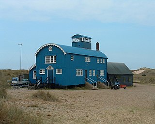
Blakeney Point is a National Nature Reserve situated near to the villages of Blakeney, Morston and Cley next the Sea on the north coast of Norfolk, England. Its main feature is a 6.4 km (4 mi) spit of shingle and sand dunes, but the reserve also includes salt marshes, tidal mudflats and reclaimed farmland. It has been managed by the National Trust since 1912, and lies within the North Norfolk Coast Site of Special Scientific Interest, which is additionally protected through Natura 2000, Special Protection Area (SPA), International Union for Conservation of Nature (IUCN) and Ramsar listings. The reserve is part of both an Area of Outstanding Natural Beauty (AONB), and a World Biosphere Reserve. The Point has been studied for more than a century, following pioneering ecological studies by botanist Francis Wall Oliver and a bird ringing programme initiated by ornithologist Emma Turner.

Ammophila arenaria is a species of grass known by the common names European marram grass and European beachgrass. It is one of two species of the genus Ammophila. It is native to the coastlines of Europe and North Africa where it grows in the sands of beach dunes. It is a perennial grass forming stiff, hardy clumps of erect stems up to 1.2 metres (3.9 ft) in height. It grows from a network of thick rhizomes which give it a sturdy anchor in its sand substrate and allow it to spread outward. These rhizomes can grow laterally by 2 metres (7 feet) in six months. One clump can produce 100 new shoots annually.

Ammophila breviligulata is a species of grass native to eastern North America, where it grows on sand dunes along the Atlantic Ocean and Great Lakes coasts. Beachgrass thrives under conditions of shifting sand, sand burial, and high winds; it is a dune-building grass that builds the first line of sand dunes along the coast. Beachgrass is less vigorous in stabilized sand, and is only infrequently found further inland than the coastal foredunes. On the Atlantic coastline of North America, Ammophila breviligulata has been observed as far south as North Carolina, and is often planted in dune restoration projects. Ammophila breviligulata was introduced to the Pacific coast of North America in the 1930s. It is proving to be invasive, and is increasingly important to coastal ecology and development in Oregon, Washington, and British Columbia.
NVC community SD19 is one of the 16 sand-dune communities in the British National Vegetation Classification system. It is one of six communities associated with foredunes and mobile dunes.
Sand dunes are common features of shoreline and desert environments. Dunes provide habitat for highly specialized plants and animals, including rare and endangered species. They can protect beaches from erosion and recruit sand to eroded beaches. Dunes are threatened by human activity, both intentional and unintentional. Countries such as the United States, Australia, Canada, New Zealand, the United Kingdom, and Netherlands, operate significant dune protection programs.
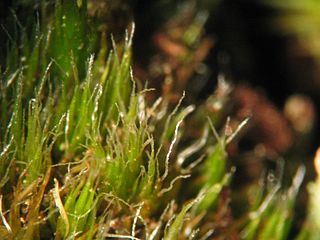
Campylopus introflexus, also known as the heath star moss, is a species of moss. The first description of the species was made by Johannes Hedwig as Dicranum introflexum in 1801.

The North Norfolk Coast Site of Special Scientific Interest (SSSI) is an area of European importance for wildlife in Norfolk, England. It comprises 7,700 ha (19,027 acres) of the county's north coast from just west of Holme-next-the-Sea to Kelling, and is additionally protected through Natura 2000, Special Protection Area (SPA) listings; it is also part of the Norfolk Coast Area of Outstanding Natural Beauty (AONB). The North Norfolk Coast is also designated as a wetland of international importance on the Ramsar list and most of it is a Biosphere Reserve.

Salix repens, the creeping willow, is a small, shrubby species of willow in the family Salicaceae, growing up to 1.5 metres in height. Found amongst sand dunes and heathlands, it is a polymorphic species, with a wide range of variants. In the UK, at least, these range from small, prostrate, hairless plants at one end of the spectrum to taller, erect or ascending silky-leaved shrubs at the other. This wide variation in form has resulted in numerous synonyms.
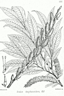
Salix daphnoides or European violet willow is a species of plant in the family Salicaceae. It can grow as a large shrub or small tree, normally reaching a height of between 6 and 8 metres, but can grow up to 12 metres tall.
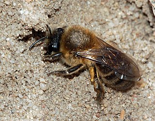
Colletes cunicularis, the vernal colletes or Spring mining bee, is a species of solitary bee from the family Colletidae which is widespread in the Palearctic from Britain to the Pacific Ocean which nests in areas of open, sandy soil.


