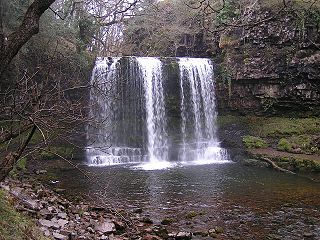
Ystradfellte is a village and community in Powys, Wales, about 6 miles (10 km) north of Hirwaun, with 556 inhabitants. It belongs to the historic county of Brecknockshire (Breconshire) and the Fforest Fawr area of the Brecon Beacons National Park, beside the Afon Mellte river. The village is linked by minor roads with Heol Senni to the north and the A4059 north of Penderyn, and with Pontneddfechan, which lies in the community, at the head of the Vale of Neath to the south.

The River Mellte is a river in south Wales. It is formed by the confluence of the Afon Llia and the Afon Dringarth. It then flows south through the village of Ystradfellte to Pontneddfechan where it joins with the Nedd Fechan to become the River Neath. The river derives its name from 'mellt' - the Welsh word for 'lightning' - after its tendency to rise and fall rapidly in response to heavy rainfall.

River Neath is a river in south Wales running south west from the point at which its headwaters arising in the Brecon Beacons National Park converge to its mouth at Baglan Bay below Briton Ferry on the east side of Swansea Bay.

Afon Hepste is a river in Powys, Wales, though partly forming the county's border with Rhondda Cynon Taf. It runs wholly within the Brecon Beacons National Park.

Henrhyd Falls in the Brecon Beacons National Park, Wales, is the tallest waterfall in southern Wales, with a drop of 90 feet (27 m). It lies on National Trust land, in the county of Powys. The nearest settlement is Coelbren, on the road between Glynneath and Abercraf. Though not in the core of the area, it is considered by many to constitute a part of Wales' celebrated Waterfall Country.

Fan Fawr is a mountain in the Fforest Fawr section of the Brecon Beacons National Park, in Powys, Wales and over 734 m (2,408 ft) high.
The Vale of Neath, one of the South Wales Valleys, encompasses the upper reaches of the River Neath in southwest Wales. In addition to the River Neath, it is traversed by the Neath Canal and the A465 dual carriageway.

The Nedd Fechan is a river almost wholly within the county of Powys, Wales. It rises on the eastern slopes of Fan Gyhirych in the Fforest Fawr section of the Brecon Beacons National Park and flows south for 7 miles (11 km) to join with the Afon Mellte at Pontneddfechan, their combined waters continuing as the River Neath to the sea near Swansea. The only significant tributary of the Nedd Fechan is the Afon Pyrddin which joins it at Pwll Du ar Byrddin. Downstream of this confluence it forms the boundary between Powys to its east and Neath Port Talbot to its west.

Fforest Fawr is an extensive upland area in the county of Powys, Wales. Formerly known as the Great Forest of Brecknock in English, it was a royal hunting area for several centuries but is now used primarily for sheep grazing, forestry, water catchment and recreation. It lies within the Brecon Beacons National Park.
The Afon Llia is a short river in Powys, Wales, and which is wholly contained within the Brecon Beacons National Park.

The Afon Twrch is a river which rises in the Black Mountain in south Wales. It forms the boundary between Powys and Carmarthenshire and, downstream of Ystradowen, between Powys and Neath Port Talbot.

Fan Nedd is a mountain in the Fforest Fawr area of the Brecon Beacons National Park in Wales. In common with the rest of the Fforest Fawr uplands it is within the county of Powys.

Fan Gyhirych is a mountain in the Fforest Fawr section of Brecon Beacons National Park in south Wales. It lies within the county of Breconshire, and administered as part of the unitary authority of Powys.
Fforest Fawr Geopark is a Geopark in the Brecon Beacons National Park, south Wales. It is the first designated Geopark in Wales having gained membership of both the European Geoparks Network and the UNESCO-assisted Global Network of National Geoparks in October 2005. The Geopark aims to promote and support sustainable tourism and other opportunities to improve the economy of the area whilst safeguarding the natural environment. Its aims largely coincide with the statutory duties and purpose of the National Park within which it sits.

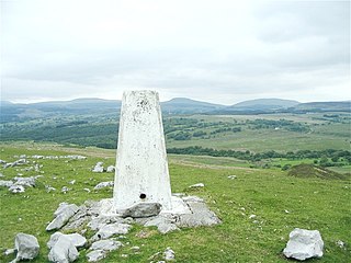
Moel Penderyn is a hill on the edge of Penderyn village, in the Brecon Beacons National Park in the county borough of Rhondda Cynon Taff, south Wales. It also appeared on older maps as 'Y Foel Penderyn'. Its summit at 371m is marked by a trig point.

The Grwyne Fawr is a river in the Brecon Beacons National Park in south Wales. A section of it forms the administrative border between Powys and Monmouthshire and also of the historic counties of Brecon and Monmouth. The river and its major tributary the Grwyne Fechan flow into the River Usk at Glangrwyney.
Penmoelallt or Onllwyn is a hill in the northern part of the county borough of Rhondda Cynon Taff in south Wales. It lies within the Brecon Beacons National Park and Fforest Fawr Geopark. To its east lies the deep valley of Cwm Taf and to its north a rather shallower valley in which the Nant Cadlan originates. To the west is the hill known as Mynydd-y-glog and to the south are slopes draining into the River Taff and the Afon Cynon. The hill culminates in a broken plateau with several knolls rising above the 420m contour. Its afforested nature makes it difficult to determine the precise location of its highest point but this probably lies somewhere around OS grid ref SO 003096. Older maps indicate a spot height of 1376 ft above sea level at SO 000090.
Waterfall Country is a name often given to the upper reaches of the Vale of Neath in South Wales. The tourist area around the head of the valley has an unusually large number of publicly accessible waterfalls. The area is not officially defined but generally includes the group of falls on the Nedd Fechan, Pyrddin, Hepste and Mellte rivers, all of which lie between the villages of Pontneddfechan and Ystradfellte in the Brecon Beacons National Park.


