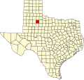
Afton, Texas | |
---|---|
Coordinates: 33°45′46″N100°49′00″W / 33.76278°N 100.81667°W [1] | |
Country | United States |
State | Texas |
County | Dickens |
Region | Llano Estacado |
Established | 1893 |
Elevation | 2,536 ft (773 m) |
Time zone | UTC-6 (CST) |
ZIP code | 79220 [2] |
Area code | 806 |
Afton is an unincorporated community in northern Dickens County, Texas, United States. [3]
A post office was established in the community under the name Beckton in 1893, and the name was changed to Afton in 1900. [4] The present name is derived from the poem Sweet Afton by Robert Burns. [5]
The Patton Springs Independent School District serves area students.
Fluvanna is an unincorporated community in Scurry County, Texas, United States. It lies just south of the Llano Estacado high atop the caprock, where Farm to Market Road 1269 and Farm to Market Road 612 intersect.
Ira is an unincorporated community in Scurry County, Texas, United States. It lies in the southwestern corner of the county at the junction of State Highway 350 and Farm to Market Road 1606, 10 miles southwest of Snyder, and has an estimated population of 250.
Prairie Dog Town Fork Red River is a sandy-braided stream about 120 mi (193 km) long, formed at the confluence of Palo Duro Creek and Tierra Blanca Creek, about 1.8 mi (2.9 km) northeast of Canyon in Randall County, Texas, and flowing east-southeastward to the Red River about 1 mi (2 km) east of the 100th meridian, 8 mi (13 km) south-southwest of Hollis, Oklahoma.
The Pease River is a river in Texas, United States. It is a tributary of the Red River that runs in an easterly direction through West Texas. It was discovered and mapped for the first time in 1856 by Jacob de Córdova, who found the river while surveying for the Galveston, Houston and Henderson Railroad Company; it was named after Texas Governor Elisha M. Pease. In December 1860, the Texas Rangers recaptured Cynthia Ann Parker and her daughter from the Comanche Indians at an engagement along the river.
Clairemont is a ghost town in and the former county seat of Kent County, Texas, United States. It is at the intersection of U.S. Route 380 and Texas State Highway 208, 14 mi (23 km) southwest of Jayton and 43 mi (69 km) east of Post. Clairemont lies near the center of Kent County, and the estimated population as of the 2000 census was 15.
Cone is an unincorporated community in Crosby County, Texas, United States. It lies on U.S. Route 62, thirty-four miles northeast of Lubbock, has an estimated population of 70, and is the location of the Harmony Plains Singing School.
Dougherty is a small unincorporated community in Floyd County, Texas, United States.
Double Mountains is the name of a pair of flat-topped buttes located 13 miles (21 km) southwest of Aspermont in Stonewall County, Texas. While the Handbook of Texas gives their elevation as either 2,000 ft (610 m) or 2,400 ft (732 m), United States Geological Survey maps give the elevation of the western mountain as 2,523 ft (769 m) and that of the eastern mountain as between 2,580 and 2,600 ft. Together, the mountains form part of the high ground dividing the watersheds of the Salt Fork and Double Mountain Fork Brazos River.
Waring is an unincorporated community in northwestern Kendall County, Texas, United States. It lies along local roads and the Guadalupe River, northwest of the city of Boerne, the county seat of Kendall County. Its elevation is 1,345 feet (410 m). Although Waring is unincorporated, it has a post office, with the ZIP code of 78074; the ZCTA for ZIP Code 78074 had a population of 59 at the 2000 census. The community is part of the San Antonio Metropolitan Statistical Area.
Mulberry Creek is an intermittent stream about 58 mi (93 km) long, formed as a shallow draw on the high plains of the Llano Estacado in Armstrong County, Texas, and flowing southeastward to join the Prairie Dog Town Fork Red River in Hall County, Texas.
The North Fork Red River, sometimes called simply the "North Fork", is a tributary of the Red River of the South about 271 mi (436 km) long, heading along the eastern Caprock Escarpment of the Llano Estacado about 11.4 mi (18.3 km) southwest of Pampa, Texas. Rising in Gray County, Texas, it terminates at the confluence with Prairie Dog Town Fork of the Red River at the Texas-Oklahoma border.
Tierra Blanca Creek is an ephemeral stream about 75 mi (121 km) long, heading in Curry County, New Mexico, flowing east-northeast across northern portions of the Llano Estacado to join Palo Duro Creek to form the Prairie Dog Town Fork Red River southeast of Amarillo, Texas. Overall, Tierra Blanca Creek descends 1,050 ft (320 m) from its headwaters in Eastern New Mexico to its confluence with Palo Duro Creek at the head of Palo Duro Canyon.
Rhineland is an unincorporated community in Knox County, Texas, United States. According to the Handbook of Texas, the community had an estimated population of 100 in 2000.
Flomot is an unincorporated community in Motley County, Texas, United States. According to the Handbook of Texas, the community had an estimated population of 181 in 2000.
Sagerton is an unincorporated community in Haskell County, Texas, United States.
Peacock is an unincorporated community in Stonewall County, Texas, United States. According to the Handbook of Texas, the community had an estimated population of 125 in 2000.
The Double Mountain Fork Brazos River is an ephemeral, sandy-braided stream about 170 mi (280 km) long, heading on the Llano Estacado of West Texas about 11.5 mi (18.5 km) southeast of Tahoka, Texas, flowing east-northeast across the western Rolling Plains to join the Salt Fork, forming the Brazos River about 18 mi (29 km) west-northwest of Haskell, Texas.
The Little Red River is an intermittent stream about 30 mi (48 km) long, formed at the confluence of the North Prong and South Prong Little Red River in Briscoe County, Texas, and flowing east-northeastward to join the Prairie Dog Town Fork Red River in Hall County, Texas.
Whiteflat is a ghost town in Motley County, Texas, United States. The population was estimated to be 3 at the 2000 census.
Quitaque Creek is an intermittent stream about 40 mi (64 km) long, originating as a shallow draw on the high plains of the Llano Estacado in Floyd County, Texas, and flowing eastward to join the North Pease River in Motley County, Texas.