Aheri, Gadchiroli

Last updated

Aheri
Town
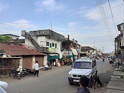
Street view of Aheri town.jpg
Main street in Aheri
India Maharashtra location map.svg
Red pog.svg
Aheri
Location in Maharashtra, India
Coordinates: 19°24′42″N80°00′14″E / 19.4117°N 80.0039°E / 19.4117; 80.0039
CountryFlag of India.svg  India
State Maharashtra
District Gadchiroli
Elevation
120 m (390 ft)
Population
 (2011)
  Total117,000
  Density2,282.70/km2 (5,912.2/sq mi)
Languages
  Official Marathi
Time zone UTC+5:30 (IST)
442705
07133

Aheri is a town and a tehsil and a district sub-division in Gadchiroli district in the Indian state of Maharashtra. It is located on the bank of Pranhita River, a tributary of Godavari River. This town is situated at the border of the Indian states of Maharashtra and Telangana. Aheri is known for its unity among the people. It represents religious, cultural and linguistic diversity. Aheri is among two Scheduled Area listed under Gadhiroli district by Government Of India. Viththal Rukhmai Mandir is the famous temple here, located right at the heart of the town.

Contents

Recently[ when? ] its urban status has been advanced to "Nagar Panchayat" from Gram Panchayat earlier on account of its rapid growth and development.

The Bridge Project on River Pranhita is in progress which creates physical links between Aheri in Maharashtra and Gudem in Telangana which promotes the historical cultural relations between the regions. This project is also expected to boost the economic growth of the town. Aheri is located at. [1] It has an average elevation of 120 metres (396 feet).Here the main issue is with roads and peoples are helpful and now Raje Dharmarao Baba Atram is MLA and hence looking forward for development and the Nagar Panchayat of Aheri is near to police station in Gadaheri area well now the work of Maharashtra-Telangana bridge which was under construction now the work is completed before few months/years and hence here many waterfalls are also located. It has good culture and historical heritage, like Rajwada of Aheri, and the main attraction is on the occasion of Dussehra when about 20000 to 50000 peoples are visiting here to celebrate.

Aheri sub-division

Aheri is a sub-division of Gadchiroli district and consist of Aheri, Etapalli, Bhamragad and Sironcha tehsils.

Demographics

As per Indian government census of year 2011, the population of tehsil was 1,16,992. [2]

YearMaleFemaleTotal PopulationChangeReligion (%)
HinduMuslimChristianSikhsBuddhistJainOther religions and persuasionsReligion not stated
2001 [3] 5240251357103759-86.6063.1120.3990.0508.0070.0151.4010.409
2011 [2] 58916580761169920.12886.9943.0830.4000.0508.0320.0111.0860.344

Related Research Articles

<span class="mw-page-title-main">Godavari River</span> River in India

The Godavari is India's second longest river after the Ganga river and drains into the third largest basin in India, covering about 10% of India's total geographical area. Its source is in Trimbakeshwar, Nashik, Maharashtra. It flows east for 1,465 kilometres (910 mi), draining the states of Maharashtra (48.6%), Telangana (18.8%), Andhra Pradesh (4.5%), Chhattisgarh (10.9%) and Odisha (5.7%). The river ultimately empties into the Bay of Bengal through an extensive network of distributaries. Measuring up to 312,812 km2 (120,777 sq mi), it forms one of the largest river basins in the Indian subcontinent, with only the Ganga and Indus rivers having a larger drainage basin. In terms of length, catchment area and discharge, the Godavari is the largest in peninsular India, and had been dubbed as the Dakshina Ganga.

<span class="mw-page-title-main">Gadchiroli district</span> District of Maharashtra in India

Gadchiroli district is an administrative district in Maharashtra, India. The city of Gadchiroli is the administrative headquarters of the district.

<span class="mw-page-title-main">Chandrapur district</span> District of Maharashtra in India

Chandrapur district is a district in the Nagpur Division in the Indian state of Maharashtra. Chandrapur was the largest district in India until the Gadchiroli and Sironcha tehsils were separated as Gadchiroli district in 1981. In 2011, the district population was 2,204,307.

Gadchiroli is a city and a municipal council in Gadchiroli district in the state of Maharashtra, central India. It is located on eastern side of Maharashtra, and is the administrative headquarters of the district. Gadchiroli is called a lung of Maharashtra as it has almost 35% of this district has forest cover. The main river flowing through city is the Wainganga River. The landscape is lush and green during the monsoon season which is prone to flooding. Gadchiroli is known for its forests. Teak is grown commercially and bamboos are used for various crafts.

The administrative divisions of India are subnational administrative units of India; they are composed of a nested hierarchy of administrative divisions.

Local government. in Maharashtra State follows the general structure of Local Governance in India and is broadly classified into two categories: Urban Local Governance and Rural Local Governance.

<span class="mw-page-title-main">Bhamragad</span> Village in Maharashtra, India

Bhamragad is a Village and a taluka and a district sub-division in Gadchiroli district in the Indian state of Maharashtra.

<span class="mw-page-title-main">Armori</span> Town in Maharashtra, India

Armori is a city and municipal council in the Gadchiroli district in the Indian state of Maharashtra. It is connected with the National Highway NH-353C.

Dharni (CT) is a Nagar Panchayat and Census Town city in Amravati district in the Indian state of Maharashtra. The Dharni Census Town has population of 15,761 of which 8,075 are males while 7,686 are females as per report released by Census of India 2011. It is the headquarters of Dharni tehsil and forms the terminus of the high road through the hills from Paratwada to Burhanpur. It is 97 km (60 mi) distant from Paratwada and 148 km (92 mi) from Amravati.

<span class="mw-page-title-main">Pranhita River</span> River in India

The Pranhita River is the largest tributary of Godavari River covering about 34% of its drainage basin conveying the combined waters of the Penganga River, the Wardha River, and the Wainganga River. By virtue of its extensive network of tributaries, the river drains a large part of Vidarbha region in Maharashtra, as well as the southern slopes of the Satpura Range in southeast Madhya Pradesh. It flows along the border of Gadchiroli district in Maharashtra and Komaram Bheem Asifabad district in Telangana. The Pranahita sub-basin is the seventh largest in India, measuring about 109,078 km2, making it larger than the individual basins of significant rivers such as the Narmada River and Kaveri.

Nethakani, also known as Netkani,As Nethkani in Maharashtra,In the state of Telangana it is known as nethakaani. are a Maratha and Telugu caste of cotton weavers and laborers.

A tehsil is a local unit of administrative division in India and Pakistan. It is a subdistrict of the area within a district including the designated populated place that serves as its administrative centre, with possible additional towns, and usually a number of villages. The terms in India have replaced earlier terms, such as pargana (pergunnah) and thana.

Sironcha is a town and municipal council in Gadchiroli district of Maharashtra state in India. It connected with NH-63.

Armori Assembly constituency is one of the 288 Vidhan Sabha constituencies of Maharashtra state in central India.

GanjiRamayyapetha is a hamlet in the Sironcha Tehsil of Gadchiroli district of Maharashtra, India.

Amgaon Vidhan Sabha seat is one of the constituencies of Maharashtra Legislative Assembly, in India.

Pakhanjur, also known as Pakhanjore, is a town, nagar panchayat, and the headquarters of the eponymous tehsil in the Kanker District of Chhattisgarh State in India. According to the 2011 Census of India, it is the second largest town in the district by population, only second to the district headquarters Kanker. It is located 120 km (75 mi) south-west of Kanker and 47 km (29 mi) west of the block headquarters Koyalibeda.

Pilode is a village located in Amalner Tehsil of Jalgaon district in Maharashtra, India. It is situated 10 km away from sub-district headquarter Amalner and 65 km away from district headquarter Jalgaon.

<span class="mw-page-title-main">Bannar River</span> River in Gadchiroli, Maharashtra

Bannar river is a minor river in Gadchiroli district of Maharashtra. It is a minor tributary of Pranhita River and falls into it near Aheri.

References

  1. Falling Rain Genomics, Inc - Aheri
  2. 1 2 Census India 2011.
  3. Census India 2001.