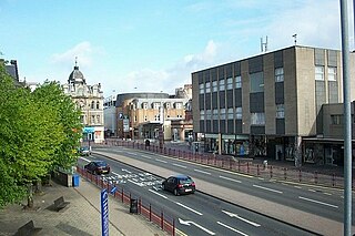
Hamilton is a large town in South Lanarkshire, Scotland. It serves as the main administrative centre of the South Lanarkshire council area. It sits 10 miles (16 km) south-east of Glasgow, 37 miles (60 km) south-west of Edinburgh and 74 miles (120 km) north of Carlisle. It is situated on the south bank of the River Clyde at its confluence with the Avon Water. Hamilton is the county town of the historic county of Lanarkshire and is the location of the headquarters of the modern local authority of South Lanarkshire.

Rutherglen is a town in South Lanarkshire, Scotland, immediately south-east of the city of Glasgow, three miles from its centre and directly south of the River Clyde. Having previously existed as a separate Lanarkshire burgh, in 1975 Rutherglen lost its own local council and administratively became a component of the City of Glasgow District within the Strathclyde region. In 1996 the towns were reallocated to the South Lanarkshire council area.

Motherwell is a town and former burgh in North Lanarkshire, Scotland, United Kingdom, south east of Glasgow. It has a population of around 32,120. Historically in the parish of Dalziel and part of Lanarkshire, Motherwell is the headquarters for North Lanarkshire Council. Geographically the River Clyde separates Motherwell from Hamilton to the west whereas the South Calder Water separates Motherwell from Carfin to the north-east and New Stevenston and Bellshill towards the north.
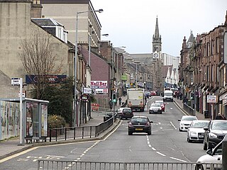
Wishaw is a large town in North Lanarkshire, Scotland, on the edge of the Clyde Valley, 15 miles (24 km) south-east of Glasgow city centre.

Bellshill is a town in North Lanarkshire in Scotland, ten miles southeast of Glasgow city centre and 37 mi (60 km) west of Edinburgh. Other nearby localities are Motherwell 2 mi (3 km) to the south, Hamilton 3 mi (5 km) to the southwest, Viewpark 1+1⁄2 mi (2.5 km) to the west, Holytown 2 mi (3 km) to the east and Coatbridge 3 mi (5 km) to the north.
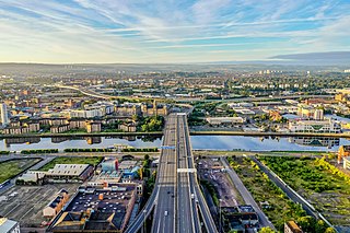
The city of Glasgow, Scotland, has a transport system encompassing air, rail, road and an underground light metro line. Prior to 1962, the city was also served by trams. Commuters travelling into Glasgow from the neighbouring local authorities of North and South Lanarkshire, Renfrewshire, East Renfrewshire, and East and West Dunbartonshire have a major influence on travel patterns, with tens of thousands of residents commuting into the city each day. The most popular mode of transport in the city is the car, used by two-thirds of people for journeys around the city.

Uddingston is a small town in South Lanarkshire, Scotland. It is on the north side of the River Clyde, south-east of Glasgow city centre, and acts as a dormitory suburb for the city.

Whifflet is a suburb of Coatbridge, Scotland, which once formed its own distinctive village. It is referred to, locally, as "The Whifflet".

Toryglen is a district in southern Glasgow, Scotland, falling within the Langside ward under Glasgow City Council. It is approximately two miles south of the city centre, bounded to the west by Mount Florida, the north-west by Polmadie, to the north-east by the West Coast Main Line railway and the M74 motorway the south by King's Park, and immediately to the east by the town of Rutherglen.
Sandyhills is an area of the Scottish city of Glasgow. It is situated north of the River Clyde and has fallen within the Shettleston ward of Glasgow City Council since 2007.
Sighthill is a neighbourhood in the Scottish city of Glasgow. It is situated north of the River Clyde and is part of the wider Springburn district in the north of the city. It is bordered to the north by Cowlairs, to the east by the Springburn Bypass road and the Royston neighbourhood, to the west by the Glasgow to Edinburgh via Falkirk Line and to the south by the Townhead interchange of the M8 Motorway.

Ravenscraig is a town and historic village, located in North Lanarkshire, Scotland, 2 miles east of Motherwell. Ravenscraig was formerly the site of Ravenscraig steelworks; once the largest hot strip steel mill in western Europe, the steelworks closed in 1992, and is now almost totally demolished.

The A730 road in Scotland runs between the centre of Glasgow and the south-eastern edge of the city's urban area at Cathkin.

Gowkthrapple is a small neighbourhood of Wishaw, Scotland, situated around 3⁄4 miles (1.2 km) from the town centre. The name "Gowkthrapple" is a Scots compound word made up of "gowk", meaning "idiot" or "cuckoo" and "thrapple", meaning "throat" or "strangle". One theory of how the community gained its name is that there was a woodland here which was notable for cuckoos. Gowkthrapple can be entered off of Castlehill Road which runs the length of the estate. Formerly an industrial area, associated with the Pather Iron and Steel Works and then Smith's clock factory, which opened in 1951. This closed in the 1970s, although the premises remain standing on Smith Avenue and have been reused as Garrion Business Park. In mid 2020, Gowkthrapple had an estimated population of 1,040.

Muirhouse is a residential suburb in the south-east of Motherwell, North Lanarkshire, Scotland, coming under the Motherwell South East & Ravenscraig council ward and bordering the Flemington neighbourhood in the town, plus the Craigneuk and Netherton areas of Wishaw. It consists of thirteen tower blocks, amidst low rise flats and numerous houses.

Braidhurst High School is a non-denominational secondary school in the suburb of Motherwell known as Forgewood, North Lanarkshire, Scotland. As of June 2023, the school has a pupil roll of approx. 600 with a teaching staff equivalent of 50 FTE teachers.

Whitlawburn is a residential area in the town of Cambuslang in South Lanarkshire, Scotland. It is located south of the town centre on high ground overlooking the Greater Glasgow urban area.

Broomhouse is a residential area in Glasgow, Scotland. It is about six miles east of the city centre. Historically a small mining village and later the site of the Glasgow Zoo, in the early 21st century it grew substantially as an affluent commuter suburb.

The A724 road in Scotland runs within South Lanarkshire between Rutherglen and Hamilton. It follows an ancient route which is marked on William Roy's Lowland Map of Scotland (1755) with only minor deviations from its modern course.

The Lanark County Buildings, also referred to as the South Lanarkshire Council Headquarters, is a local government facility in Hamilton, Scotland.

