
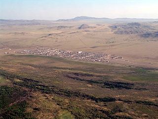
Turan is a town and the administrative center of Piy-Khemsky District in the Tuva Republic, Russia, located 70 kilometers (43 mi) northwest of Kyzyl, the capital of the republic. As of the 2010 Census, its population was 4,981.

Shagonar is a town and the administrative center of Ulug-Khemsky District in the Tuva Republic, Russia, located on the left bank of the Yenisei River, 124 kilometers (77 mi) west of Kyzyl, the capital of the republic. As of the 2010 Census, its population was 10,956.

Mongun-Tayginsky District is an administrative and municipal district, one of the seventeen in the Tuva Republic, Russia. It is located in the southwest of the republic. Its administrative center is the rural locality of Mugur-Aksy. Population: 5,661 (2010 Census); 5,938 ; 5,576 (1989 Soviet census). The population of Mugur-Aksy accounts for 73.4% of the district's total population.

Chaa-Kholsky District is an administrative and municipal district, one of the seventeen in the Tuva Republic, Russia. It is located in the west of the republic. The area of the district is 2,900 square kilometers (1,100 sq mi). Its administrative center is the rural locality of Chaa-Khol. Population: 6,036 (2010 Census); 6,532. The population of Chaa-Khol accounts for 53.8% of the district's total population.

Chedi-Kholsky District is an administrative and municipal district which is one of the seventeen in the Tuva Republic, Russia. It is located in the center of the republic. The area of the district is 3,707 square kilometers (1,431 sq mi). Its administrative center is the rural locality of Khovu-Aksy. Population: 7,685 (2010 Census); 8,081. The population of Khovu-Aksy accounts for 47.8% of the district's total population.

Erzinsky District is an administrative and municipal district, one of the seventeen in the Tuva Republic, Russia. It is located in the south and southeast of the republic. The area of the district is 11,081.45 square kilometers (4,278.57 sq mi). Its administrative center is the rural locality of Erzin. As of the 2010 Census, the total population of the district was 8,280, with the population of Erzin accounting for 38.5% of that number.

Kaa-Khemsky District is an administrative and municipal district, one of the seventeen in the Tuva Republic, Russia. It is located in the center and east of the republic. The area of the district is 25,726.04 square kilometers (9,932.88 sq mi). Its administrative center is the rural locality of Saryg-Sep. Population: 12,279 (2010 Census); 13,071 ; 14,982 (1989 Soviet census). The population of Saryg-Sep accounts for 36.0% of the district's total population.
Ovyursky District is an administrative and municipal district, one of the seventeen in the Tuva Republic, Russia. It is located in the southwest of the republic. The area of the district is 4,400 square kilometers (1,700 sq mi). Its administrative center is the rural locality of Khandagayty. Population: 7,022 (2010 Census); 7,930 ; 8,868 (1989 Soviet census). The population of Khandagayty accounts for 45.7% of the district's total population.

Sut-Kholsky District is an administrative and municipal district, one of the seventeen in the Tuva Republic, Russia. It is located in the west of the republic. The area of the district is 6,691.25 square kilometers (2,583.51 sq mi). Its administrative center is the rural locality of Sug-Aksy. Population: 8,029 (2010 Census); 8,430 ; 12,038 (1989 Soviet census). The population of Sug-Aksy accounts for 39.7% of the district's total population.

Tandinsky District is an administrative and municipal district, one of the seventeen in the Tuva Republic, Russia. It is located in the center of the republic. The area of the district is 5,091.70 square kilometers (1,965.92 sq mi). Its administrative center is the rural locality of Bay-Khaak. Population: 12,891 (2010 Census); 13,827 ; 23,653 (1989 Soviet census). The population of Bay-Khaak accounts for 23.1% of the district's total population.

Tes-Khemsky District is an administrative and municipal district, one of the seventeen in the Tuva Republic, Russia. It is located in the south of the republic. The area of the district is 6,680 square kilometers (2,580 sq mi). Its administrative center is the rural locality of Samagaltay. Its population was 8,174 (2010 Census); 8,908 ; 10,413 (1989 Soviet census). The population of Samagaltay accounts for 39.6% of the district's total population.

Khovu-Aksy is a rural locality and the administrative center of Chedi-Kholsky District of Tuva, Russia. Population: 3,672 (2010 Census); 3,706 (2002 Census); 5,925 (1989 Soviet census).
Kyzyl-Mazhalyk is a rural locality and the administrative center of Barun-Khemchiksky District of Tuva, Russia. Population: 5,072 (2010 Census); 5,046 (2002 Census); 5,754 (1989 Soviet census).
Chaa-Khol is a rural locality and the administrative center of Chaa-Kholsky District of Tuva, Russia. Population: 3,250 (2010 Census); 3,453 (2002 Census);

Erzin is a rural locality and the administrative center of Erzinsky District of Tuva, Russia. Population: 3,191 (2010 Census); 2,977 (2002 Census); 2,707 (1989 Soviet census).

Saryg-Sep is a rural locality and the administrative center of Kaa-Khemsky District of Tuva, Russia. Population: 4,417 (2010 Census); 4,621 (2002 Census); 4,663 (1989 Soviet census).
Khandagayty is a rural locality and the administrative center of Ovyursky District of Tuva, Russia. Population: 3,207 (2010 Census); 3,173 (2002 Census); 2,930 (1989 Soviet census).

Kungurtug is a rural locality and the administrative center of Tere-Kholsky District of Tuva, Russia. Population: 1,467 (2010 Census); 1,835 (2002 Census);
Samagaltay is a rural locality and the administrative center of Tes-Khemsky District of Tuva, Russia. Population: 3,233 (2010 Census); 3,507 (2002 Census); 3,648 (1989 Soviet census).

Saldam is a rural locality located in the Todzhinsky District of Tuva, Russia. Population: 545 (2010 Census); 525 (2002 Census); It is one of the places that claims to be the geographical midpoint of Asia.


