Related Research Articles

The Arctic Archipelago, also known as the Canadian Arctic Archipelago, is an archipelago lying to the north of the Canadian continental mainland, excluding Greenland and Iceland.


Coats Land is a region in Antarctica which lies westward of Queen Maud Land and forms the eastern shore of the Weddell Sea, extending in a general northeast–southwest direction between 20°00′W and 36°00′W. The northeast part was discovered from the Scotia by William S. Bruce, leader of the Scottish National Antarctic Expedition, 1902-1904. He gave the name Coats Land for James Coats, Jr., and Major Andrew Coats, the two chief supporters of the expedition.
The Forrestal Range is a largely snow-covered mountain range, about 105 km (65 mi) long, standing east of Dufek Massif and the Neptune Range in the Pensacola Mountains of Antarctica. Discovered and photographed on 13 January 1956 on a transcontinental patrol plane flight of U.S. Navy Operation Deep Freeze I from McMurdo Sound to the vicinity of the Weddell Sea and return.
The Neptune Range is a mountain range, 112 km (70 mi) long, lying WSW of Forrestal Range in the central part of the Pensacola Mountains in Antarctica. The range is composed of Washington Escarpment with its associated ridges, valleys and peaks, the Iroquois Plateau, and the Schmidt and Williams Hills. It was discovered and photographed on 13 January 1956 on a US Navy transcontinental plane flight from McMurdo Sound to Weddell Sea and return.

Veststraumen Glacier is a glacier about 45 miles long draining west along the south end of Kraul Mountains into Riiser-Larsen Ice Shelf. The glacier was seen in the course of a U.S. Navy LC-130 plane flight over the coast on November 5, 1967, and was plotted by the United States Geological Survey (USGS) from photographs obtained at that time. In 1969, the Advisory Committee on Antarctic Names (US-ACAN) gave the name "Endurance Glacier" to this feature, but that naming was rescinded because UK Antarctic Place-Names Committee (UK-APC) gave the identical name to a small glacier on Elephant Island. The descriptive name "Veststraumen" appears on a 1972 Norsk Polarinstitutt map.

The Stancomb-Wills Glacier is a large glacier that debouches into the eastern Weddell Sea southward of Lyddan Island. The glacier was discovered in the course of the U.S. Navy LC-130 plane flight over the coast on November 5, 1967, and was plotted by the United States Geological Survey (USGS) from photographs obtained at that time. The name was applied by the Advisory Committee on Antarctic Names (US-ACAN) in 1969.
Ronne Entrance is a broad southwest entrance of the George VI Sound where it opens from the southeast portion of the Bellingshausen Sea at the southwest side of Alexander Island, Antarctica. The south side of the Monteverdi Peninsula occupies the north portion of the Ronne Entrance while Ellsworth Land occupies the southern portion of the entrance. The entrance receives much ice throughout the whole year mainly because the entrance protrudes eastward into the adjacent George VI Sound and the George VI Ice Shelf from the southwest section, the Ronne Entrance is also prone to ice flow from the Bach Ice Shelf as well as receiving ice from the Wilkins Ice Shelf. There are a few islands situated within the Ronne Entrance, mainly in the southwest area. Some of these islands include the Eklund Islands, DeAtley Island, Spaatz Island, Case Island and Smyley Island. It was discovered on a sledge journey through the sound in December 1940 by U.S. Polar explorer Finn Ronne and Carl Eklund of the US Antarctic Service (USAS), 1939–41, and named "Ronne Bay". Finn Ronne covered more miles by ski and sled dog than any other explorer in history and mapped the last unknown coastline on earth on his Ronne Antarctic Research Expedition in 1947.

RV Akademik Fedorov is a Russian scientific diesel-electric research vessel, the flagship of the Russian polar research fleet. It was built in Rauma, Finland for the Soviet Union and completed on 8 September 1987. It started operations on 24 October 1987, in the USSR. The ship was named after a Soviet polar explorer, academician of the USSR Academy of Sciences Evgeny Fyodorov, who worked on the first Soviet manned drifting ice station North Pole-1.
Albert Bank, also known as Prince Albert I Bank, is a submarine bank in the Weddell Sea named for Albert I of Monaco, instrumental in initiating the first GEBCO charts (1903). The name was proposed by Dr. Heinrich Hinze, Alfred Wegener Institute for Polar and Marine Research, Bremerhaven, Germany, and approved in June 1997.
Weddell Plain is an undersea abyssal plain named in association with the Weddell Sea. Name approved 6/87.

King Haakon VII Sea is a proposed name for part of the Southern Ocean on the coast of East Antarctica.
Cline Glacier is a large glacier that drains the vicinity at the east side of Mount Jackson and flows generally southeast between Schirmacher Massif and Rowley Massif into the head of Odom Inlet, on the east side of Palmer Land. It was mapped by United States Geological Survey in 1974, and named by the Advisory Committee on Antarctic Names for David R. Cline, United States Antarctic Research Program biologist on the International Weddell Sea Oceanographic Expeditions in 1968 and 1969.
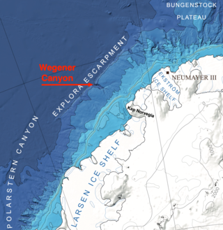
Wegener Canyon is a submarine canyon named for Alfred Wegener. It is located between Kap Norvegia and the Explora Escarpment as a feature for sediment transport at the Antarctic continental margin. The Canyon was mapped during various expeditions of the German research vessel RV Polarstern with a swath sonar system. The name was proposed by Hans Werner Schenke, Alfred Wegener Institute for Polar and Marine Research, Bremerhaven, Germany. Name approved 7/89.

The Dawson-Lambton Glacier is a heavily crevassed glacier entering the south-eastern Weddell Sea immediately west of the Brunt Ice Shelf. It was discovered in January 1915 by a British expedition led by Ernest Shackleton. He named it for Elizabeth Dawson-Lambton, a benefactress of the Shackleton expeditions.
Murrish Glacier is a glacier about 15 nautical miles (28 km) long on the east side of Palmer Land, Antarctica. It drains east-northeast, to the north of Stockton Peak and Abendroth Peak, and merges with the north side of Gain Glacier before the latter enters the Weddell Sea opposite Morency Island. It was named by the Advisory Committee on Antarctic Names (US-ACAN) for David E. Murrish, United States Antarctic Research Program (USARP) biologist and party leader for the study of peripheral vascular control mechanisms in birds in the Antarctic Peninsula region for three seasons, 1972–75.
Hill Nunatak is a prominent nunatak rising above the ice at the southeast end of the Neptune Range in the Pensacola Mountains of Antarctica, 8 nautical miles (15 km) east-northeast of Gambacorta Peak. It was discovered and photographed on January 13, 1956, during a U.S. Navy transcontinental plane flight from McMurdo Sound to the Weddell Sea and return, and was named by the Advisory Committee on Antarctic Names for Jack O. Hill, an aerial photographer on this flight.
The Hofmann Trough is a submarine bank in the Weddell Sea. It is named for Walther Hofmann (1920–1993), a cartographer/photogrammetrist on polar expeditions. The name was proposed by Heinrich Hinze of the Alfred Wegener Institute for Polar and Marine Research, Bremerhaven, Germany, and was approved by the Advisory Committee for Undersea Features in June 1997.

The Lassiter Coast is the portion of the east coast of the Antarctic Peninsula that extends from Cape Mackintosh to Cape Adams. The northern portion of this coast was discovered and photographed from the air by the United States Antarctic Service in 1940. During 1947 the entire extent of the coast was photographed from the air by the Ronne Antarctic Research Expedition (RARE) under Finn Ronne, who in conjunction with the Falkland Islands Dependencies Survey charted it from the ground.

The Riiser-Larsen Sea is one of the marginal seas located in the Southern Ocean off East Antarctica and south of the Indian Ocean. It is delimited Astrid Ridge in the west and the Gunnerus Ridge and the Kainanmaru Bank in the east. It is bordered by the Lazarev Sea to the west and the Cosmonauts Sea to the east, or between 14°E and 30°E. Its northern border is defined to be the 65th parallel south. The name, proposed by the Soviet Union, was never officially approved by the International Hydrographic Organization (IHO).
References
 This article incorporates public domain material from "Akademik Federov Canyon". Geographic Names Information System . United States Geological Survey.
72°45′S32°0′W / 72.750°S 32.000°W

| | This Coats Land location article is a stub. You can help Wikipedia by expanding it. |