Al-Ittihad, Ramallah

Last updated

Contents

Al-Ittihad
Arabic transcription(s)
   Arabic الاتحاد
Palestine location map wide.png
Red pog.svg
Al-Ittihad
Location of Al-Ittihad within Palestine
Coordinates: 31°58′24″N35°06′13″E / 31.97333°N 35.10361°E / 31.97333; 35.10361
StateFlag of Palestine.svg  State of Palestine
Governorate Ramallah and al-Bireh
Founded1997
Government
  Type Municipality
  Head of MunicipalityFaisal Bazzar [1]
Population
 (2007 [2] )
  Total
6,803
Website www.ittihad-mun.org

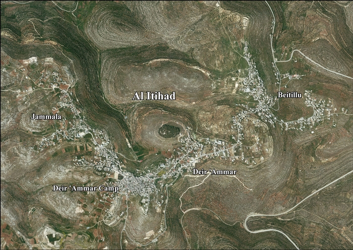
Al-Ittihad (Arabic : الاتحاد meaning "the Union") is a Palestinian town in the Ramallah and al-Bireh Governorate of the State of Palestine, created in 1997 as a merger of three towns Beitillu, Deir 'Ammar and Jammala. According to the Palestinian Central Bureau of Statistics, it had a population of approximately 6,803 in 2007. [2]

Location of Al-Ittihad

Al-Itihad is located 12.5 kilometers (7.8 mi) northwest of Ramallah. Al-Itihad is bordered by Kobar and Al-Zaytouneh to the east, Deir Abu Mash'al, Deir Nidham and 'Abud to the north, Shabtin and Deir Qaddis to the west, and Ras Karkar, Kharbatha Bani Harith, Al-Zaytouneh and Al Janiya to the south. [3]

Beitillu

Beitillu (Arabic : بيتللو) is a Palestinian town located in the Ramallah and al-Bireh Governorate in the northern West Bank, 19 kilometers Northwest of Ramallah. According to the Palestinian Central Bureau of Statistics, it had a population of approximately 3,083 in mid-year 2006 [4]

Deir 'Ammar

Deir 'Ammar (Arabic : دير عمار) is a Palestinian town in the Ramallah and al-Bireh Governorate, located 17 kilometers Northwest of Ramallah in the northern West Bank. According to the Palestinian Central Bureau of Statistics (PCBS), the town had a population of 2,414 inhabitants in mid-year 2006. [4]

Jammala

Jammala (Arabic : جمّالا) is a Palestinian town in the Ramallah and al-Bireh Governorate, located 18 kilometers Northwest of Ramallah in the northern West Bank. According to the Palestinian Central Bureau of Statistics (PCBS), the town had a population of 1,453 inhabitants in mid-year 2006. [4]

Post-1967

After the 1995 accords, 41.2% of Al-Ittihad's land was classified as Area B and the remaining 58.8% as Area C. Israel has confiscated 858 dunams of land from Al-Ittihad for the construction of 4 Israeli settlements: Nahliel, Na'ale, Talmon and Halamish. [5]

Related Research Articles

<span class="mw-page-title-main">Shuqba</span> Palestinian town in Ramallah and al-Bireh, State of Palestine

Shuqba is a Palestinian town in the Ramallah and al-Bireh Governorate, located 17 kilometers northwest of the city of Ramallah in Palestine.

<span class="mw-page-title-main">Ramallah and al-Bireh Governorate</span> Governorate of Palestine

The Ramallah and al-Bireh Governorate is one of 16 governorates of Palestine. It covers a large part of the central West Bank, on the northern border of the Jerusalem Governorate. Its district capital or muhfaza (seat) is the city of al-Bireh.

<span class="mw-page-title-main">Deir Dibwan</span> Municipality type D in Ramallah and al-Bireh, State of Palestine

Deir Dibwan is a Palestinian city in the Ramallah and al-Bireh Governorate in the central West Bank east of Ramallah. It is also the capital of the Eastern District with Mr. Iyad Mohammad Habbas Al-Awawdah the mayor. According to the Palestinian Central Bureau of Statistics the town had a population of 4,169 inhabitants in 2017. There were 5,016 people from Deir Dibwan living abroad. Deir Dibwan was built close to the ruins of Et-Tell.

<span class="mw-page-title-main">Salfit Governorate</span> Governorate of Palestine

Salfit governorate is one of the 16 Governorates of the State of Palestine. It is located in the northwestern West Bank, held under Israeli occupation, bordered by the governorates of Ramallah and al-Bireh to the south, Nablus to the east and Qalqilya in the north as well as, Israel to the west. Its district capital and largest city is Salfit. According to the Palestinian Central Bureau of Statistics (PCBS), the governorate had a population of 75,444 inhabitants in mid-year 2017. In the PCBS's census in 1997, which registered 46,671 residents, refugees accounted for 7.7% of the total population. There were 37,613 male residents and 36,143 females.

<span class="mw-page-title-main">Jalazone</span> Refugee Camp in Ramallah and al-Bireh, State of Palestine

Jalazone is a Palestinian refugee camp in the Ramallah and al-Bireh Governorate, located 7 kilometers (4.3 mi) north of Ramallah and adjacent to the village of Jifna to the north, Deir Dibwan to the east, Bir Zeit to the west and the Beit El Israeli settlement to the southeast.

<span class="mw-page-title-main">Beitillu</span> Municipality type C in Ramallah and al-Bireh, State of Palestine

Beitillu is a Palestinian town located in the Ramallah and al-Bireh Governorate in the northern West Bank, 19 kilometers Northwest of Ramallah. According to the Palestinian Central Bureau of Statistics, it had a population of 3,465 in 2017.

<span class="mw-page-title-main">Beit Sira</span> Municipality type D in Ramallah and al-Bireh, State of Palestine

Beit Sira is a Palestinian village in the central West Bank, located 22 kilometers west of Ramallah and is a part of the Ramallah and al-Bireh Governorate. The village is situated along the Green Line. During the 1948 Arab-Israeli War, around 4,000 dunams of its land became a part of the "No-Man's Land" strip between the north-central West Bank and Israel. Currently Beit Sira's jurisdiction is 3,120 dunams, of which 441 dunams are built-up areas and the remainder is open spaces for future construction or agricultural land.

<span class="mw-page-title-main">Deir Abu Mash'al</span> Municipality type C in Ramallah and al-Bireh, State of Palestine

Deir Abu Mash'al is a Palestinian village in the Ramallah and al-Bireh Governorate of the State of Palestine, located 24 kilometers (15 mi) west of Ramallah in the northern West Bank. According to the Palestinian Central Bureau of Statistics (PCBS), the village had a population of 4,233 inhabitants in 2017.

<span class="mw-page-title-main">Deir as-Sudan</span> Municipality type C in Ramallah and al-Bireh, State of Palestine

Deir as-Sudan is a Palestinian town in the Ramallah and al-Bireh Governorate, located 20 kilometers Northwest of Ramallah in the northern West Bank. According to the Palestinian Central Bureau of Statistics (PCBS), the town had a population of approximately 2,159 inhabitants in 2017.

<span class="mw-page-title-main">Burqa, Ramallah</span> Municipality type C in Ramallah and al-Bireh, Palestine

Burqa is a town in the Ramallah and al-Bireh Governorate, located east of Ramallah in the northern West Bank, Palestine. According to the Palestinian Central Bureau of Statistics (PCBS), the town had a population of 2,047 inhabitants in the 2017 census.

<span class="mw-page-title-main">Jammala</span> Municipality type C in Ramallah and al-Bireh, State of Palestine

Jammala is a Palestinian town in the Ramallah and al-Bireh Governorate, located 18 kilometers Northwest of Ramallah in the northern West Bank. According to the Palestinian Central Bureau of Statistics (PCBS), the town had a population of 1,664 inhabitants in 2017.

<span class="mw-page-title-main">Deir 'Ammar</span> Municipality type D in Ramallah and al-Bireh, State of Palestine

Deir 'Ammar is a Palestinian town in the Ramallah and al-Bireh Governorate, located 17 km (11 mi) northwest of Ramallah in the northern West Bank. According to the Palestinian Central Bureau of Statistics (PCBS), the town had a population of 3,353 inhabitants in 2017.

Deir Ammar Camp is a Palestinian refugee camp located in the Ramallah and al-Bireh Governorate, approximately 30 kilometers (19 mi) northwest of Ramallah in the northern West Bank. According to the Palestinian Central Bureau of Statistics (PCBS), the camp had a population of 1,884 inhabitants in 2017.

<span class="mw-page-title-main">Ein Qiniya</span> Local Development Committee in Ramallah and al-Bireh, State of Palestine

Ein Qiniya or 'Ayn Kiniya is a Palestinian village in the northern West Bank, located 7 kilometers (4.3 mi) northwest of Ramallah and part of the Ramallah and al-Bireh Governorate of the State of Palestine. Ein Qiniya has existed since the Roman-era of rule in Palestine. The village is very small with no public structures or institutions and is governed by a local development committee. Ein Qiniya is regionally notable for being a spring and autumn time picnic resort.

<span class="mw-page-title-main">Na'ale</span> Israeli settlement in the West Bank

Na'ale is an Israeli settlement in the West Bank. Located near Modi'in, it falls under the jurisdiction of Mateh Binyamin Regional Council. In 2022 it had a population of 2,839.

<span class="mw-page-title-main">Nahliel</span> Israeli settlement in the West Bank

Nahliel is a Haredi Israeli settlement in the West Bank. Located close to the Palestinian villages of Beitillu and Deir 'Ammar, and some 20 kilometres (12 mi) from Modi'in, it is organised as a community settlement and falls under the jurisdiction of the Mateh Binyamin Regional Council. In 2022 it had a population of 743.

<span class="mw-page-title-main">Burham, Ramallah</span> Local Development Committee in Ramallah and al-Bireh, State of Palestine

Burham is a Palestinian village in the Ramallah and al-Bireh Governorate located twelve kilometers north of Ramallah. The largest nearby town is Bir Zeit located to the southeast. The average elevation of Burham is 680 meters above sea level. The village was established during the Byzantine Empire rule over Palestine.

<span class="mw-page-title-main">Deir Nidham</span> Municipality type D in Ramallah and al-Bireh, State of Palestine

Deir Nidham is a Palestinian village in the Ramallah and al-Bireh Governorate in the central West Bank. It is located approximately 23 kilometers (14 mi) northwest of the city of Ramallah and its elevation is 590 meters (1,940 ft). According to the Palestinian Central Bureau of Statistics (PCBS) 2017 census, the town had a population of 876.

<span class="mw-page-title-main">Al-Zaitounah</span> Municipality type C in Ramallah and al-Bireh, State of Palestine

Al-Zaitounah is a Palestinian town in the Ramallah and al-Bireh Governorate of the State of Palestine. It was formed in 2005 as the result of a merger of the villages of Abu Shukheidim and al-Mazra'a al-Qibliya. In 2007, al-Zaitounah had a population of 6,190, according to the Palestinian Central Bureau of Statistics.

<span class="mw-page-title-main">Kharbatha Bani Harith</span> Municipality type D in Ramallah and al-Bireh, State of Palestine

Kharbatha Bani Harith is a Palestinian village in the central West Bank, located 15 kilometers west of Ramallah in the Ramallah and al-Bireh Governorate. According to the Palestinian Central Bureau of Statistics, the village had a population of 3,471 in 2017. It has a total land area of 7,120 dunams.

References