Sanjil (unofficial)"},"type":{"wt":"[[Municipality (Palestinian Authority)|Municipality type C]]"},"image_skyline":{"wt":"File:Sinjil4140.JPG"},"image_caption":{"wt":""},"pushpin_map":{"wt":"Palestine"},"pushpin_map_caption":{"wt":"Location of Sinjil within [[State of Palestine|Palestine]]"},"image_map":{"wt":""},"map_caption":{"wt":""},"coordinates":{"wt":"{{coord|32|01|59|N|35|15|51|E|region:PS|display=inline,title}}"},"grid_name":{"wt":"[[Palestine grid|Palestine grid]]"},"grid_position":{"wt":"175/160"},"subdivision_type":{"wt":"State"},"subdivision_name":{"wt":"{{flag|State of Palestine}}"},"subdivision_type1":{"wt":"[[Governorates of the Palestinian National Authority|Governorate]]"},"subdivision_name1":{"wt":"[[Ramallah and al-Bireh Governorate]]"},"established_title":{"wt":"Founded"},"established_date":{"wt":""},"government_footnotes":{"wt":""},"government_type":{"wt":"[[Municipality (Palestinian Authority)|Municipality]]"},"leader_title":{"wt":"Head of Municipality"},"leader_name":{"wt":"Mutaz Tawafsha"},"unit_pref":{"wt":"dunam"},"area_footnotes":{"wt":""},"area_total_km2":{"wt":""},"area_total_dunam":{"wt":""},"elevation_footnotes":{"wt":"[http://vprofile.arij.org/ramallah/pdfs/vprofile/sinjil_tp_en.pdf Sinjil Town Profile], ARIJ, p. 4"},"elevation_m":{"wt":"795"},"elevation_min_m":{"wt":""},"elevation_max_m":{"wt":""},"population_footnotes":{"wt":"{{cite report |date=February 2018 |title=Preliminary Results of the Population, Housing and Establishments Census, 2017 |url=https://www.pcbs.gov.ps/Downloads/book2364-1.pdf |department=[[Palestinian Central Bureau of Statistics]] (PCBS) |publisher=[[State of Palestine]] |pages=64–82 |access-date=2023-10-24}}"},"population_total":{"wt":"5742"},"population_as_of":{"wt":"2017"},"population_note":{"wt":""},"population_density_km2":{"wt":"auto"},"blank_name_sec1":{"wt":"Name meaning"},"blank_info_sec1":{"wt":"Saint GillesPalmer, 1881, p. [https://archive.org/stream/surveyofwesternp00conduoft#page/245/mode/1up 245]"},"website":{"wt":""},"footnotes":{"wt":""},"official_name":{"wt":""}},"i":0}}]}" id="mwBA">Municipality type C in Ramallah and al-Bireh Governorate, State of Palestine
Sinjil | |
---|---|
Arabic transcription(s) | |
• Arabic | سنجل |
• Latin | Senjel (official) Sanjil (unofficial) |
| |
Location of Sinjil within Palestine | |
Coordinates: 32°01′59″N35°15′51″E / 32.03306°N 35.26417°E | |
Palestine grid | 175/160 |
State | ![]() |
Governorate | Ramallah and al-Bireh Governorate |
Government | |
• Type | Municipality |
• Head of Municipality | Mutaz Tawafsha |
Elevation | 795 m (2,608 ft) |
Population (2017) [2] | |
• Total | 5,742 |
Name meaning | Saint Gilles [3] |
Sinjil (Arabic : سنجل) is a Palestinian town northeast of Ramallah in the Ramallah and al-Bireh Governorate of the State of Palestine, in the central West Bank.
Sinjil is located 15.5 kilometers (9.6 mi) north-east of Ramallah. It is bordered by Turmus ayya to the east, Al Lubban ash Sharqiya to the north, 'Abwein and Jilijliya to the west, and Al Mazra'a ash Sharqiya to the south. [1] Sinjil is located in the Ramallah and al-Bireh Governorate of the West Bank.
Sherds from the Intermediate Bronze Age, Bronze Age, Byzantine, Crusader/Ayyubid and Mamluk periods have been found. [4] Tombs at Sinjil from the Middle Bronze Age have yielded an array of metal weapons. [5]
The village is thought to have taken its name from the Crusader town of St. Gilles, [3] being the home town of French Count Raymond VI of Toulouse [6] who camped here on the First Crusade, before entering Jerusalem. [7] The same man later built a castle in Sinjil to protect the passage of passing caravans. [8]
Doubt over the Crusader origin of the name was raised by historian Levy-Rubin. [9] A Samaritan chronicle (ostensibly by Abu l-Fath), written in the 14th century but based on much older sources, twice refers to a location Sinḥil in the 8th or 9th century. [9] The Arab geographer Zakariya al-Qazwini in his Athar al-bilad cited a 10th-century mention of Sinḥil, though this cannot be verified from extant manuscripts. [9] Levy-Rubin proposes that Sinḥil was the original name of Sinjil, and that the Crusaders' association of the place with St Gilles was prompted by the Arab name rather than the reverse. [9]
In the 1220s Yaqut al-Hamawi described Sinjil as "a small town of the province Filastin. Near it is the pit of Yasuf as Sadik (Joseph)". [10]
The village paid ecclesiastical tithes to the Church of the Holy Sepulchre in Jerusalem while a Frankish parish, until they were transferred in 1145 to the monastery on Mount Tabor. [11] [12] [13]
Only thirty years later, in 1175, the parish church and tithes were sold back to the Church of the Holy Sepulchre, as the distance from Mount Tabor and expenses were too high. [13] [14] A month later the sale was confirmed by Baldwin, lord of Sinjil. [13] [15]
In 1517 the village was incorporated into the Ottoman Empire with the rest of Palestine. In 1596 it appeared in the tax registers as being in the Nahiya of Quds of the Liwa of Quds. It had a population of 55 households, all Muslim, and paid a fixed tax rate of 33,3% on wheat, barley, vineyards, fruit trees, goats and beehives; a total of 9,900 akçe. [16] [17] The Turkish traveler Evliya Çelebi visited Sinjil about 1650. He described it as a village of 200 houses in the district of Jerusalem, populated by rebellious Muslims. [18]
During the early 19th century, Sinjil was a village of 206 taxable men, roughly 800 people. One-eighth of the population were conscripted into the Ottoman army, but were still taxed for 800 people. [19]
French explorer Victor Guérin visited the village in 1870, and described it as "quite crowded", with an estimated 1200 villagers. The village had two abundant springs, with a reservoir connected to the largest. [20] Guérin further noted, "On the summit of the hill are observed the foundations of two strongholds, built of great blocks, evidently ancient, one of which is called the Kasr ("Fort"), and the other the Keniseh ("Church"). The latter is [] built east and west, and may have been a church. On the lower flanks of the hill I found several ancient tombs cut in the rock. One of the largest, preceded by a vestibule, contains two loculi." [21] An Ottoman village list of about the same year, 1870, showed that "Sindschil" had 161 houses and a population of 513, though the population count included only men. [22] [23]
In 1882, the PEF's Survey of Western Palestine described Sinjil as being of moderate size, with several houses of two storeys, on a hill side with fine fig gardens below. [6]
The village mosque is laid out on the lines of the Frankish Crusader church (see section above). [11] Other historical sites in the town include a well for Joseph and a holy site for Jacob. The maqam (shrine) of a holy man, Abu Auf, is also there. Abu Auf is from the time period of Caliph Umar Ibn al-Khattab. [8]
In 1896 the population of Sinjil was estimated to be about 1,131 persons. [24]
In the 1922 census of Palestine conducted by the British Mandate authorities, Sinjil (called: Senjel) had an entirely Muslim population of 934, [25] while in the 1931 census, the village had 266 occupied houses and a population of 1071, still all Muslims. [26]
In 1922, Tawfiq Canaan documented the belief among some of the villagers that the biblical Joseph was thrown into a pit in the proximity of Sinjil. Locals attributed significance to a well called Bir Sinjil. Some said it was the abode of a saint named Sheikh Saleh, while others said it was connected to the prophet Yusuf. [27]
In the 1945 statistics the population was 1,320 Muslims [28] while the total land area was 14,186 dunams, according to an official land and population survey. [29] Of this, 4,169 were allocated for plantations and irrigable land, 4,213 for cereals, [30] while 47 dunams were classified as built-up (urban) areas. [31]
In the wake of the 1948 Arab–Israeli War, and after the 1949 Armistice Agreements, Sinjil came under Jordanian rule. It was annexed by Jordan in 1950.
In 1961, the population of Sinjil was 1,778 persons. [32]
Since the Six-Day War in 1967, Sinjil has been under Israeli occupation. The population of Singil in the 1967 census conducted by the Israeli authorities was 1,823, of whom 18 originated from the Israeli territory. [33]
Under the Oslo Accords of 1995, 13.8% of village land was classified as Area A, 34.7% as Area B, while the remaining 51.5% is Area C. Israel has confiscated 447 dunams of Sinjil land in order to construct the Israeli settlement of Ma'ale Levona. In addition four outposts, including Givat Harel, have been established on Sinjil land. [34]
On Wednesday, 7 April 2015, a 32-year-old resident of Sinjil stabbed and injured two paramedics sitting in an ambulance near the entrance to Shiloh. One was hospitalized in serious condition. The perpetrator was killed. [35]
On 26 March 2023, Israeli settlers threw a Molotov cocktail at a house in Sinjil which caught fire. The family escaped without injury. [36] [37]
According to Amira Hass, Jewish settlers have hampered villagers' access to their traditional lands. In August 2012, the Red Cross helped the villagers to coordinate with the Israeli Civil Administration and the Israel Defense Forces forces, enabling them to work on 100 hectares of the land accompanied by an escort. [38] In January 2012, the United States Agency for International Development financed road work and renovations of the Abu Bakr as-Saddeeq boys' school in Sinjil. [39]
According to the Palestinian Central Bureau of Statistics, the town had a population of 5,742 in 2017. [2] The gender makeup consisted of 2,668 males and 2,568 females. There were 1,029 housing units and the average household size was 5.4. [40]
In 2007, Aziz Shihab whose family was from Sinjil, wrote a memoir of his journey to the village Does the Land Remember Me? (2007). [41] [42]
His daughter, Naomi Shihab Nye, who stayed there in 1966, aged 14, and recalls her sojourn as having a formative influence on her poetics. [43]
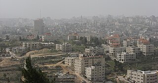
Al-Bireh, al-Birah, or el-Bira is a Palestinian city in the central West Bank, 15 kilometers (9.3 mi) north of Jerusalem. It is the capital of the Ramallah and al-Bireh Governorate of the State of Palestine. It is situated on the central ridge running through the West Bank and is 860 meters (2,820 ft) above sea level, covering an area of 22.4 square kilometers (8.6 sq mi). Al-Bireh is under the administration of the Palestinian National Authority.
Taybeh is a Christian Palestinian village in the West Bank, 15 kilometers northeast of Jerusalem and 12 kilometers northeast of Ramallah, in the Ramallah and al-Bireh Governorate of Palestine. It is 850 meters above sea level. According to the Palestinian Central Bureau of Statistics, Taybeh had a population of 1,340 in 2017.
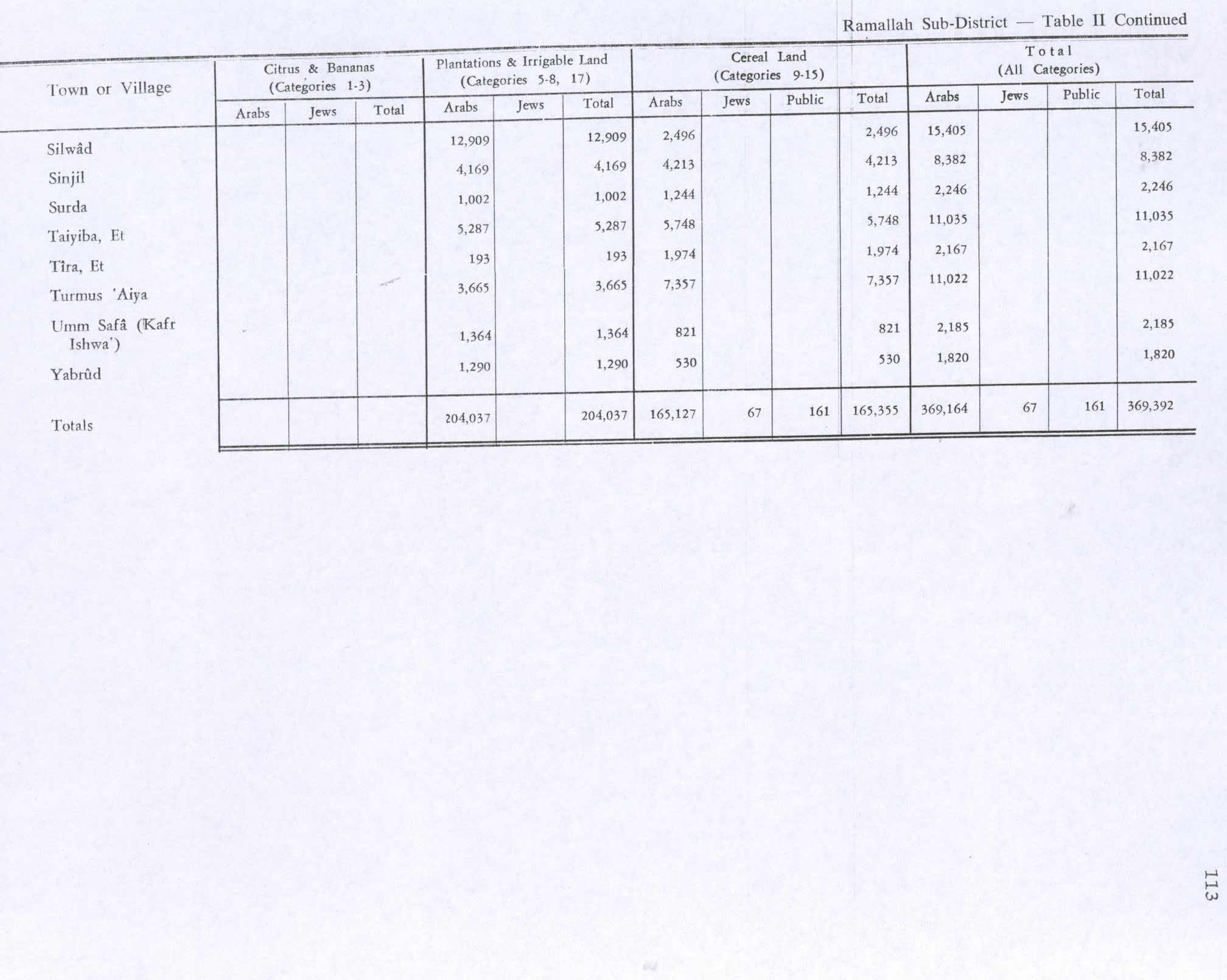
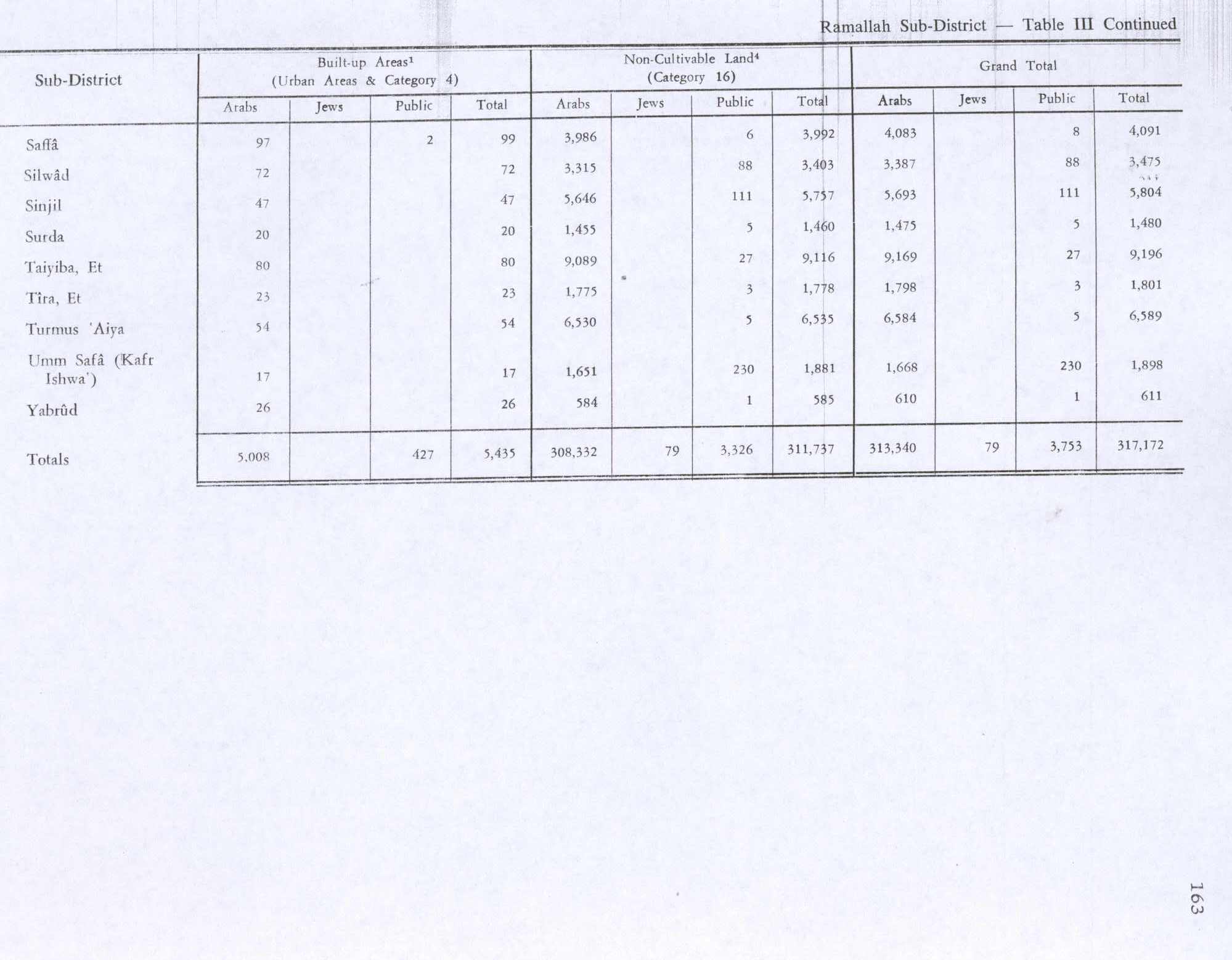
Turmus Ayya is a Palestinian town located in the Ramallah and al-Bireh Governorate in the West Bank, in Palestine. According to the Palestinian Central Bureau of Statistics (PCBS), it had a population of 2,464 in 2017. A large percentage of the residents are Palestinian binationals with US citizenship.
Aboud is a Palestinian village in the Ramallah and al-Bireh Governorate of the State of Palestine, in the central West Bank, northwest of Ramallah and 30 kilometers north of Jerusalem. Nearby towns include al-Lubban to the northeast and Bani Zeid to the northwest.
Beitunia, also Bitunya, is a Palestinian city located 3 kilometers (1.9 mi) west of Ramallah and 14 kilometers (8.7 mi) north of Jerusalem, in the Ramallah and al-Bireh Governorate of Palestine, in the central West Bank. According to the Palestinian Central Bureau of Statistics, the city had a population of 26,604 in 2017, making it the third largest locality in its governorate after al-Bireh and Ramallah.
Al-Lubban al-Gharbi is a Palestinian village in the Ramallah and al-Bireh Governorate, located 21 kilometers northwest of Ramallah in the northern West Bank. According to the Palestinian Central Bureau of Statistics, the village had a population of 1,566 inhabitants in 2017.
Abwein is a Palestinian village in the Ramallah and al-Bireh Governorate of the State of Palestine, located about 37 kilometers north of Ramallah, in the northern West Bank. According to the Palestinian Central Bureau of Statistics, Abwein's population was 3,496 in 2017.
Ajjul is a Palestinian village in the Ramallah and al-Bireh Governorate in the northern West Bank, located north of Ramallah. There are two archaeological sites or khirbets to the east of the village. One of the khirbets is dedicated to a former resident of Ajjul, Sheikh Abdul. Ajjul is governed by a village council of three members.
Beitin is a Palestinian village in the Ramallah and al-Bireh Governorate in the central West Bank, located 5 kilometers (3.1 mi) northeast of Ramallah along the Ramallah-Nablus road. The Palestinian village of Dura al-Qar' and Ein Yabrud lie to the north, Rammun to the east, Deir Dibwan to the southeast and al-Bireh to the southwest. The Israeli settlement of Beit El is northwest of Beitin.
Kafr 'Aqab is the northernmost Palestinian Arab neighborhood in East Jerusalem. It is part of the area annexed and included in municipal Jerusalem following its occupation by Israel in 1967. This area includes an additional approximate 64 km2 (25 sq mi) of the West Bank, including territory which previously included 28 villages and areas of the Bethlehem and Beit Jala municipalities. Although the Jerusalem Law did not use the term, the Israeli Supreme Court interpreted the law as an effective annexation of East Jerusalem. The United Nations Security Council condemned the attempted change in status to Jerusalem and ruled the law "null and void" in United Nations Security Council Resolution 478.
Abu Qash is a Palestinian village located in the Ramallah and al-Bireh Governorate in the northern West Bank, located north of Ramallah and south of the Birzeit University. According to the 2017 census conducted by the Palestinian Central Bureau of Statistics, it had a population of 2,237.
Deir Abu Mash'al is a Palestinian village in the Ramallah and al-Bireh Governorate of the State of Palestine, located 24 kilometers (15 mi) west of Ramallah in the northern West Bank. According to the Palestinian Central Bureau of Statistics (PCBS), the village had a population of 4,233 inhabitants in 2017.
al-Mazra'a ash-Sharqiya is a Palestinian town in the Ramallah and al-Bireh Governorate, located northeast of Ramallah in the northern West Bank. According to the Palestinian Central Bureau of Statistics (PCBS), the town had a population of 4,063 inhabitants in 2017.
Jammala is a Palestinian town in the Ramallah and al-Bireh Governorate, located 18 kilometers Northwest of Ramallah in the northern West Bank. According to the Palestinian Central Bureau of Statistics (PCBS), the town had a population of 1,664 inhabitants in 2017.
Beit Surik is a Palestinian village in the Jerusalem Governorate, located 12 kilometers Northwest of Jerusalem in the northern West Bank. According to the Palestinian Central Bureau of Statistics, the town had a population of 4,025 in 2017.
Ein Qiniya or 'Ayn Kiniya is a Palestinian village in the northern West Bank, located 7 kilometers (4.3 mi) northwest of Ramallah and part of the Ramallah and al-Bireh Governorate of the State of Palestine. Ein Qiniya has existed since the Roman-era of rule in Palestine. The village is very small with no public structures or institutions and is governed by a local development committee. Ein Qiniya is regionally notable for being a spring and autumn time picnic resort.
Al-Qubeiba is a Palestinian town in the Jerusalem Governorate of Palestine, located 2 kilometers northwest of Jerusalem in the central West Bank. According to the Palestinian Central Bureau of Statistics in 2017, the village had a population of 3,876. Al-Qubeiba lies at an altitude of 783m to 795m above sea-level. It is located in a conflict area near the border with Israel between Ramallah and Jerusalem. The settlement of Giv'on HaHadashah lies 5 km southeast of al-Qubeiba. It is surrounded by the town of Biddu (east), Beit 'Anan (northwest), Qatanna (southwest), and Kharayib Umm al-Lahim (west). Unlike the surrounding region, al-Qubeiba has large areas covered with pine and olive trees.
Ein Siniya is a small Palestinian village in the Ramallah and al-Bireh Governorate, 10 kilometers (6.2 mi) north of Ramallah, and approximately 1km northeast from Jifna. It lies in a valley surrounded with olive and fig-terraces.
Abu Shukheidim was a Palestinian village in the Ramallah and al-Bireh Governorate.
Jibiya is a Palestinian village in the Ramallah and al-Bireh Governorate. It was founded after the 16th century. It is mentioned in text from 1697.