Beitillu

Last updated

Contents

Beitillu
Arabic transcription(s)
   Arabic بيت إللو
   Latin Beitillu (official)
qry@ bytllw (lbld@ lqdym@)flsTyn.JPG
Beitillu
Palestine location map wide.png
Red pog.svg
Beitillu
Location of Beitillu within Palestine
Coordinates: 31°58′33″N35°06′54″E / 31.97583°N 35.11500°E / 31.97583; 35.11500
Palestine grid 161/153
State State of Palestine
Governorate Ramallah and al-Bireh
Government
  Type Municipality
Elevation
[1]
531 m (1,742 ft)
Population
 (2017) [2]
  Total
3,465
Name meaning"The house of Ello" [3]

Beitillu (Arabic : بيت إللو) is a Palestinian town located in the Ramallah and al-Bireh Governorate in the northern West Bank, 19 kilometers Northwest of Ramallah. According to the Palestinian Central Bureau of Statistics, it had a population of 3,465 in 2017. [2]

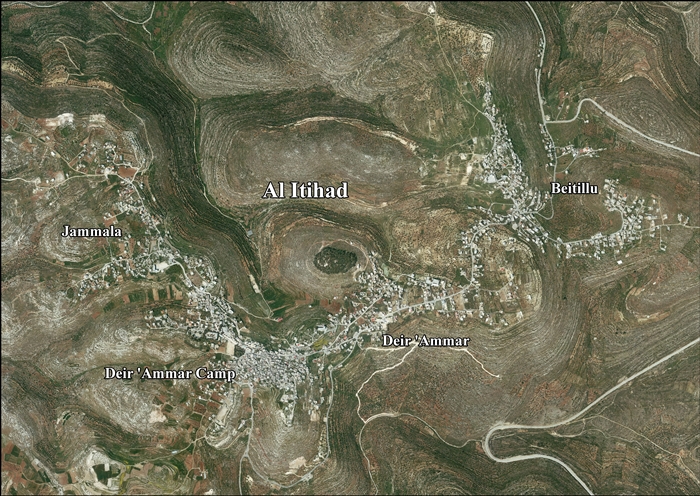
Presently much of the villagers' traditional land, springs, gardens with olive and fig trees, near the Israeli settlement of Nachliel cannot be accessed, because their way is barred by Israeli soldiers or settlers, often with dogs. [4]

Beitillu, together with Deir 'Ammar and Jammala, form the new town of Al-Ittihad. [1]

Location of Al-Ittihad

Al-Itihad is located 12.5 kilometers (7.8 mi) northwest of Ramallah. Al-Itihad is bordered by Kobar and Al-Zaytouneh to the east, Deir Abu Mash'al, Deir Nidham and 'Abud to the north, Shabtin and Deir Qaddis to the west, and Ras Karkar, Kharbatha Bani Harith, Al-Zaytouneh and Al Janiya to the south. [1]

History

Sherds from Iron Age II/ Persian, Hellenistic, Roman, Byzantine, Umayyad, Crusader, Ayyubid and Mamluk era have been found at Beitillu. [5] Finkelstein and Lederman mention remains of ancient structures, most of them in the village's east, and note that the Mandatory DOA documented ancient quarries here. [6]

Abel, Klein and Safrai all identified Beitillu with Ayyalon, a place mentioned in Midrash Vayisau. [6] Yoel Elitzur asserts that the name Beitillu may be derived from "Bethel", the name of several Israelite settlements of the Iron Age, including the well-known Bethel in Benjamin and another one listed in Judah. He proposed that Beitillu might be the site of Bethel in Mount Ephraim, which the Book of Judges (4:5) mentions as being close to the Palm of Deborah. [7]

Prawer and Benvenisti associated Beitillu with a medieval site bearing the same name, which, according to Mayer, belonged to the monastery of Mons Gaudii (Nebi Samwil). [6]

Ottoman era

Beitillu appeared in the 1596 Ottoman tax registers as Bayt Illu, in the Nahiya of Quds of the Liwa of Quds. It had a population of 30 households, all Muslim. They paid a fixed tax-rate of 33.3% on agricultural products, including wheat, barley, olive trees, vineyards and fruit trees, goats and beehives, in addition to occasional revenues; a total of 14,500 Akçe. [8]

In 1838 Beit Ello was noted as Muslim village in the Beni Harith district, north of Jerusalem. [9] [10]

French explorer Victor Guérin visited Beit-Illou in 1870, and he estimated that the village had about 800 inhabitants. He also noted that it had "magnificent trees" to the north. [11] Guérin´s population estimate fits well with an official Ottoman village list from about 1870, which showed that Beit Oula had 100 houses and a population of 430, although it only counted the men. [12] [13]

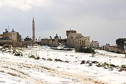
In 1882, the PEF's Survey of Western Palestine described Beit Ello as a "village of moderate size on high ground, among olives, with a well to the south-east, and a spring and a tank on the north-east". [14]

In 1896 the population of Bet Illo was estimated to be about 588 persons. [15]

British Mandate era

In the 1922 census of Palestine, conducted by the British Mandate authorities, Baitilla had a population of 252 Muslims, [16] increasing in the 1931 census to a population of 440, still all Muslim, in 98 houses. [17]

In the 1945 statistics the population of Beitillu was 490 Muslims, [18] with 13,409 dunams of land, according to an official land and population survey. [19] 5,825 dunams were used for plantations and irrigable land, 1,681 dunams for cereals, [20] while 58 dunams were built-up (urban) land. [21]

Jordanian era

After the 1948 Arab-Israeli War, Beitillu was under Jordanian rule from 1948 until 1967.

In 1961, the population was 1,535 persons. [22]

post-1967

Beitillu came under Israeli occupation after the 1967 Six-Day War. The population in the 1967 census conducted by the Israeli authorities was 848, of whom 174 originated from the Israeli territory. [23]

After the 1995 accords, 41.2% of Al-Ittihad‘s land was classified as Area B and the remaining 58.8% as Area C. Israel has confiscated 858 dunams of land from Al-Ittihad for the construction of 4 Israeli settlements: Nahl'iel, Na'aleh, Talmon and Hallamish. [24]

Much of the villagers' traditional land, springs, gardens with olive and fig trees, near the Israeli settlement of Nachliel cannot be accessed, according to Amira Hass, because their way is barred by soldiers or settlers, often with dogs:-

This has been going on for years. Gradually, ever-expanding rings of grazing land and rows of groves have become inaccessible to residents of the Beitillu and Deir Ammar villages.' [4]

One villager complained:

“I have 200 olive trees, 500 fig trees and 300 vines there. I can’t even pick a single fig,” stated a Palestinian farmer who looks older than his age; he spoke without cynicism, and with much pain. “They aren’t killing me, but they are killing my heart.” [4]

In February 2011, three Beitillu houses were vandalised by anonymous graffiti artists who painted slogans like 'Muhammad is a pig' on their walls, probably as a price tag policy retaliation for the forced evacuation of a settler outpost near Kiryat Arba. [25]

Related Research Articles

<span class="mw-page-title-main">Shuqba</span> Palestinian town in Ramallah and al-Bireh, State of Palestine

Shuqba is a Palestinian town in the Ramallah and al-Bireh Governorate, located 17 kilometers northwest of the city of Ramallah in Palestine.

<span class="mw-page-title-main">Deir Ballut</span> Municipality type D in Salfit, State of Palestine

Deir Ballut is a Palestinian town in the Salfit Governorate in the northern West Bank, 41 kilometers (25 mi) south west of Nablus. According to the Palestinian Central Bureau of Statistics, it had a population of 3,873 in 2017.

<span class="mw-page-title-main">Deir Dibwan</span> Municipality type D in Ramallah and al-Bireh, State of Palestine

Deir Dibwan is a Palestinian city in the Ramallah and al-Bireh Governorate in the central West Bank east of Ramallah. It is also the capital of the Eastern District with Mr. Iyad Mohammad Habbas Al-Awawdah the mayor. According to the Palestinian Central Bureau of Statistics the town had a population of 4,169 inhabitants in 2017. There were 5,016 people from Deir Dibwan living abroad. Deir Dibwan was built close to the ruins of Et-Tell.

<span class="mw-page-title-main">Ein Yabrud</span> Municipality type C in Ramallah and al-Bireh, State of Palestine

Ein Yabrud is a Palestinian town in the Ramallah and al-Bireh Governorate in the central West Bank. It is located approximately 7 km northeast of the city of Ramallah and its elevation is 800 m. According to the Palestinian Central Bureau of Statistics (PCBS) the town had a population of 2,515 in 2017.

<span class="mw-page-title-main">Al-Lubban al-Gharbi</span> Municipality type D in Ramallah and al-Bireh, State of Palestine

Al-Lubban al-Gharbi is a Palestinian village in the Ramallah and al-Bireh Governorate, located 21 kilometers northwest of Ramallah in the northern West Bank. According to the Palestinian Central Bureau of Statistics, the village had a population of 1,566 inhabitants in 2017.

<span class="mw-page-title-main">Deir Qaddis</span> Municipality type D in Ramallah and al-Bireh, State of Palestine

Deir Qaddis is a Palestinian town in the Ramallah and al-Bireh Governorate of the State of Palestine, in the central West Bank, located sixteen kilometers west of Ramallah. According to the Palestinian Central Bureau of Statistics, the town had a population of 2,452 inhabitants in 2017. The town consists of 8,207 dunams, of which 438 dunams are classified as built-up area. As a result of 1995 accords, 7.7% of Deir Qaddis' land was transferred to the Palestinian National Authority for civil affairs, so-called Area B, but Israel still retains full control of 92.3% of the town, being in Area C.

Ajjul is a Palestinian village in the Ramallah and al-Bireh Governorate in the northern West Bank, located north of Ramallah. There are two archaeological sites or khirbets to the east of the village. One of the khirbets is dedicated to a former resident of Ajjul, Sheikh Abdul. Ajjul is governed by a village council of three members.

<span class="mw-page-title-main">Dura al-Qar'</span> Municipality type D in Ramallah and al-Bireh, State of Palestine

Dura al-Qar' or Dura al-Qari'a is a Palestinian town in the central West Bank, part of the Ramallah and al-Bireh Governorate. According to the Palestinian Central Bureau of Statistics, Dura al-Qar' had a population of 3,032 inhabitants in 2017.

<span class="mw-page-title-main">Salim, Nablus</span> Municipality type D in Nablus, State of Palestine

Salim is a Palestinian town in the northern West Bank, located six kilometers east of Nablus and is a part of the Nablus Governorate. According to the Palestinian Central Bureau of Statistics (PCBS), Salim had a population of 6,266 inhabitants in 2017.

<span class="mw-page-title-main">Saffa, Ramallah</span> Town in the West Bank, State of Palestine

Saffa is a Palestinian town in the Ramallah and al-Bireh Governorate, located west of Ramallah in the northern West Bank. According to the Palestinian Central Bureau of Statistics (PCBS), the town had a population of 4,374 inhabitants in 2017.

<span class="mw-page-title-main">Deir Abu Mash'al</span> Municipality type C in Ramallah and al-Bireh, State of Palestine

Deir Abu Mash'al is a Palestinian village in the Ramallah and al-Bireh Governorate of the State of Palestine, located 24 kilometers (15 mi) west of Ramallah in the northern West Bank. According to the Palestinian Central Bureau of Statistics (PCBS), the village had a population of 4,233 inhabitants in 2017.

<span class="mw-page-title-main">Deir as-Sudan</span> Municipality type C in Ramallah and al-Bireh, State of Palestine

Deir as-Sudan is a Palestinian town in the Ramallah and al-Bireh Governorate, located 20 kilometers Northwest of Ramallah in the northern West Bank. According to the Palestinian Central Bureau of Statistics (PCBS), the town had a population of approximately 2,159 inhabitants in 2017.

<span class="mw-page-title-main">Jammala</span> Municipality type C in Ramallah and al-Bireh, State of Palestine

Jammala is a Palestinian town in the Ramallah and al-Bireh Governorate, located 18 kilometers Northwest of Ramallah in the northern West Bank. According to the Palestinian Central Bureau of Statistics (PCBS), the town had a population of 1,664 inhabitants in 2017.

<span class="mw-page-title-main">Deir 'Ammar</span> Municipality type D in Ramallah and al-Bireh, State of Palestine

Deir 'Ammar is a Palestinian town in the Ramallah and al-Bireh Governorate, located 17 km (11 mi) northwest of Ramallah in the northern West Bank. According to the Palestinian Central Bureau of Statistics (PCBS), the town had a population of 3,353 inhabitants in 2017.

<span class="mw-page-title-main">Deir Ibzi</span> Municipality type C in Ramallah and al-Bireh, State of Palestine

Deir Ibzi is a Palestinian town in the Ramallah and al-Bireh Governorate, located west of Ramallah in the northern West Bank. According to the Palestinian Central Bureau of Statistics, the town had a population of 2,590 inhabitants in 2017.

<span class="mw-page-title-main">Kafr Ni'ma</span> Municipality type C in Ramallah and al-Bireh, State of Palestine

Kafr Ni'ma is a Palestinian town in the Ramallah and al-Bireh Governorate, located 13 kilometers northwest of Ramallah in the northern West Bank. According to the Palestinian Central Bureau of Statistics (PCBS), the town had a population of 4,659 inhabitants in 2017.

<span class="mw-page-title-main">Deir Nidham</span> Municipality type D in Ramallah and al-Bireh, State of Palestine

Deir Nidham is a Palestinian village in the Ramallah and al-Bireh Governorate in the central West Bank. It is located approximately 23 kilometers (14 mi) northwest of the city of Ramallah and its elevation is 590 meters (1,940 ft). According to the Palestinian Central Bureau of Statistics (PCBS) 2017 census, the town had a population of 876.

<span class="mw-page-title-main">Kharbatha Bani Harith</span> Municipality type D in Ramallah and al-Bireh, State of Palestine

Kharbatha Bani Harith is a Palestinian village in the central West Bank, located 15 kilometers west of Ramallah in the Ramallah and al-Bireh Governorate. According to the Palestinian Central Bureau of Statistics, the village had a population of 3,471 in 2017. It has a total land area of 7,120 dunams.

Al-Ittihad is a Palestinian town in the Ramallah and al-Bireh Governorate of the State of Palestine, created in 1997 as a merger of three towns Beitillu, Deir 'Ammar and Jammala. According to the Palestinian Central Bureau of Statistics, it had a population of approximately 6,803 in 2007.

<span class="mw-page-title-main">Shabtin</span> Municipality type C in Ramallah and al-Bireh, State of Palestine

Shabtin is a Palestinian village in the Ramallah and al-Bireh Governorate of the State of Palestine, in the central West Bank.

References

  1. 1 2 3 Al-Itihad Town Profile (Beitillu, Jammala & Deir 'Ammar), ARIJ, pp. 4-5
  2. 1 2 Preliminary Results of the Population, Housing and Establishments Census, 2017 (PDF). Palestinian Central Bureau of Statistics (PCBS) (Report). State of Palestine. February 2018. pp. 64–82. Retrieved 2023-10-24.
  3. Palmer, 1881, p. 226
  4. 1 2 3 Amira Hass, 'Uprooting Palestinian trees - and lives,' at Haaretz, 16 July 2012
  5. Finkelstein and Lederman, 1997, p. 374
  6. 1 2 3 Finkelstein, Israel; Lederman, Zvi; Bunimovitz, Shlomo (1997). Finkelstein, Israel; Lederman, Zvi (eds.). Highlands of Many Cultures. Jerusalem: Institute of Archaeology of Tel Aviv University Publications Section. p. 374. ISBN   965-440-007-3.
  7. Raviv, Dvir (2021). "זיהויה של רמתים: בירת טופארכיה מן התקופה החשמונאית" [The identification of Ramathaim: the capital of a toparchy from the Hasmonean period]. Judea and Samaria Research Studies (in Hebrew): 8–9. doi:10.26351/JSRS/30-1/1.
  8. Hütteroth and Abdulfattah, 1977, p. 114
  9. Robinson and Smith, 1841, vol. 3, 2nd Appendix, p. 124
  10. Robinson and Smith, 1841, vol. 3, p. 66
  11. Guérin, 1875, pp. 85-86
  12. Socin, 1879, p. 148. It was also noted that it was in the Beni Harit district
  13. Hartmann, 1883, p. 126 also noted 100 houses
  14. Conder and Kitchener, 1882, SWP II, p. 293
  15. Schick, 1896, p. 122
  16. Barron, 1923, Table VII, Sub-district of Ramallah, p. 16
  17. Mills, 1932, p. 47
  18. Government of Palestine, Department of Statistics, 1945, p. 26
  19. Government of Palestine, Department of Statistics. Village Statistics, April, 1945. Quoted in Hadawi, 1970, p. 64
  20. Government of Palestine, Department of Statistics. Village Statistics, April, 1945. Quoted in Hadawi, 1970, p. 111
  21. Government of Palestine, Department of Statistics. Village Statistics, April, 1945. Quoted in Hadawi, 1970, p. 161
  22. Government of Jordan, Department of Statistics, 1964, p. 24 It was further noted (note 2) that it was governed by a mukhtar.
  23. Perlmann, Joel (November 2011 – February 2012). "The 1967 Census of the West Bank and Gaza Strip: A Digitized Version" (PDF). Levy Economics Institute . Retrieved 24 January 2018.
  24. Al-Itihad Town Profile (Beitillu, Jammala & Deir 'Ammar), ARIJ, pp. 16-17
  25. Elior Levy, 'Muhammad is a pig' scribbled on Palestinian homes,' at Ynet, 13 February 2011.

Bibliography