Ironbridge is a riverside village in the borough of Telford and Wrekin in Shropshire, England. Located on the bank of the River Severn, at the heart of the Ironbridge Gorge, it lies in the civil parish of The Gorge. Ironbridge developed beside, and takes its name from, The Iron Bridge, a 100-foot (30 m) cast iron bridge that was built in 1779.

The Ironbridge Gorge is a deep gorge, containing the River Severn in Shropshire, England. It was first formed by a glacial overflow from the long drained away Lake Lapworth, at the end of the last ice age. The deep exposure of the rocks cut through by the gorge exposed commercial deposits of coal, iron ore, limestone and fireclay, which enabled the rapid economic development of the area during the early Industrial Revolution.

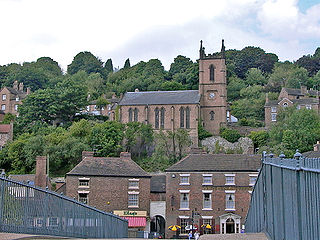
Coalbrookdale is a town in the Ironbridge Gorge and the Telford and Wrekin borough of Shropshire, England, containing a settlement of great significance in the history of iron ore smelting. It lies within the civil parish called the Gorge.

The English county of Shropshire has a fairly large railway network, with 19 National Rail stations on various national lines; there are also a small number of heritage and freight lines, including the famous heritage Severn Valley Railway running along its eastern border with Worcestershire.

The Telford Steam Railway (TSR) is a heritage railway located at Horsehay, Telford in Shropshire, England, formed in 1976.

Coalport is a village in Shropshire, England. It is located on the River Severn in the Ironbridge Gorge, a mile downstream of Ironbridge. It lies predominantly on the north bank of the river; on the other side is Jackfield. It forms part of the civil parish of the Gorge and is the south-eastern corner of the borough of Telford and Wrekin.
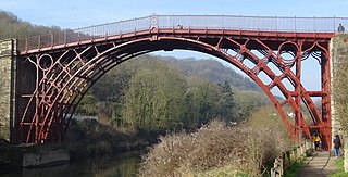
The Iron Bridge is a cast iron arch bridge that crosses the River Severn in Shropshire, England. Opened in 1781, it was the first major bridge in the world to be made of cast iron. Its success inspired the widespread use of cast iron as a structural material, and today the bridge is celebrated as a symbol of the Industrial Revolution.

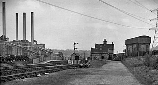
Coalbrookdale railway station is a disused station that served the town of Coalbrookdale in Shropshire, England. The station was situated on the now mothballed freight-only line between Buildwas Junction and Lightmoor Junction. The station buildings are now used by the Green Wood Centre.
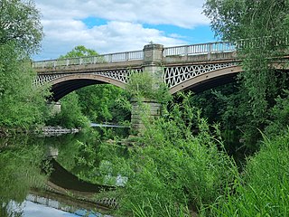
Buildwas railway station was an isolated junction railway station on the Wellington to Craven Arms Railway and Severn Valley Railway. Opened on 1 February 1862. Although the station served both the Severn Valley Railway and Wellington to Craven Arms Railway, it was an interchange station in open countryside with no passenger access except by rail.
The Wellington to Craven Arms Railway was formed by a group of railway companies that eventually joined the Great Western Railway family, and connected Wellington, Shropshire and Shifnal, with Coalbrookdale, Buildwas, Much Wenlock and a junction near Craven Arms. Its objectives were dominated by the iron, colliery and limestone industries around Coalbrookdale.
The Wenlock, Craven Arms and Lightmoor Extension Railway was a railway in Shropshire, England. It was built as two portions either end of the Much Wenlock and Severn Junction Railway between 1864 and 1867 and formed part of the Wellington to Craven Arms Railway. For much of its working life it was worked by the Great Western Railway and subsequently the Western Region of British Railways.

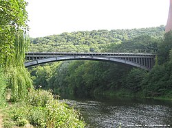
The Victoria Bridge crosses the River Severn between Arley and Bewdley in Worcestershire, England. At the time of its construction, the 200-foot railway bridge was the longest single span cast iron bridge in Britain.

Mythe Bridge carries the A438 road across the River Severn at Tewkesbury. It is a cast-iron arch bridge spanning 170 feet (52 m) and 24 feet (7.3 m) wide, designed by Thomas Telford and completed in April 1826. It is a Grade II* listed structure.

The Shropshire Canal was a tub boat canal built to supply coal, ore and limestone to the industrial region of east Shropshire, England, that adjoined the River Severn at Coalbrookdale. It ran from a junction with the Donnington Wood Canal ascending the 316 yard long Wrockwardine Wood inclined plane to its summit level, it made a junction with the older Ketley Canal and at Southall Bank the Coalbrookdale (Horsehay) branch went to Brierly Hill above Coalbrookdale; the main line descended via the 600 yard long Windmill Incline and the 350 yard long Hay Inclined Plane to Coalport on the River Severn. The short section of the Shropshire Canal from the base of the Hay Inclined Plane to its junction with the River Severn is sometimes referred to as the Coalport Canal.

The Museum of the Gorge, originally the Severn Warehouse, is one of the ten museums of the Ironbridge Gorge Museum Trust. It portrays the history of the Ironbridge Gorge and the surrounding area of Coalbrookdale, Shropshire, England.
Horsehay and Dawley railway station is a heritage railway station in the town of Dawley and village of Horsehay in the Telford and Wrekin borough of Shropshire, England. The station was opened in 1859, closed in 1962, then reopened in 1976 as part of the Telford Steam Railway. Originally, the station was on the former Wellington and Severn Junction railway. It consisted of one platform with a signal box at the end of the platform controlling access to the goods yard. It is now the working base of the Telford Steam Railway.

Lightmoor Platform railway station was a station to the east of Coalbrookdale, Shropshire, England. The station was opened in 1907 and closed in 1962. The station was situated on the Madeley Junction to Buildwas Line to the west of Lightmoor Junction.
Belvidere Bridge is a cast iron arch railway bridge in Shrewsbury, western England, built for the Shrewsbury and Birmingham Railway in 1849. It carries the modern Wolverhampton to Shrewsbury railway line over the River Severn and is a grade II* listed building.

Lawley Village is a heritage railway station on the Telford Steam Railway in the village of Lawley and near the town of Telford in the Telford and Wrekin borough of Shropshire, England. It has no station buildings and is a single platform with a passenger shelter. Work began on the station in 2005 and it was officially opened a decade later in 2015. The station is not far from the site of the former Lawley Bank station, which was only a short distance due north.

Spring Village is a heritage railway station on the Telford Steam Railway in the village of Horsehay and the town of Dawley in the Telford and Wrekin borough of Shropshire, England. It has multiple rolling stock sidings for the Telford Steam Railway, station buildings with a single platform with a passenger shelter and a crossing into an Engine shed on Pool Side. Work began on the station in 1976 and it was officially opened a decade later in 1984 when it was open to the public. The station is adjacent to Horsehay and Dawley station