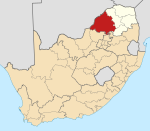
Limpopo is the northernmost province of South Africa. It is named after the Limpopo River, which forms the province's western and northern borders. The term Limpopo is derived from Rivombo (Livombo/Lebombo), a group of Tsonga settlers led by Hosi Rivombo who settled in the mountainous vicinity and named the area after their leader. The Lebombo mountains are also named after them. The river has been called the Vhembe by local Venda communities of the area. The capital and largest city in the province is Polokwane, while the provincial legislature is situated in Lebowakgomo.

The Mureș or Maros is a 789-kilometre-long (490 mi) river in Eastern Europe. Its drainage basin covers an area of 30,332 km2 (11,711 sq mi). It originates in the Hășmașu Mare Range in the Eastern Carpathian Mountains, Romania, rising close to the headwaters of the river Olt, and joins the Tisza at Szeged in southeastern Hungary. In Romania, its length is 761 km (473 mi) and its basin size is 27,890 km2 (10,770 sq mi).

The Thomson River is a perennial river that forms part of the Lake Eyre Basin, situated in the central west and western regions of Queensland, Australia. Much of the course of the river comprises a series of narrow channels synonymous with the Channel Country and the Galilee subregion.

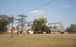
Vaalwater is a small town situated on the Mokolo River in the Limpopo province of South Africa.
Bela-Bela - formerly known as Warmbaths, Afrikaans: Warmbad- is a town in the Limpopo Province of South Africa. Deriving its name from the geothermic hot springs around which the town was built.

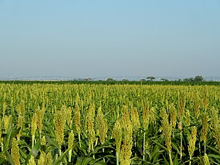
The Bushveld is a sub-tropical woodland ecoregion of Southern Africa. The ecoregion straddles the Tropic of Capricorn and constitutes the southern part of the Zambezian region. It encompasses most of Limpopo and a small part of North West in South Africa, the Central and North-East Districts of Botswana and the Matabeleland South and part of Matabeleland North provinces of Zimbabwe. The Kruger National Park has a number of 'Bushveld' camps, but these are strictly speaking in the lowveld, as these terms are sometimes used interchangeably. Although their limits are somewhat blurred, lowveld is generally restricted to the more easterly parts of South Africa and Zimbabwe.

The Crișul Alb (Romanian), is a river in western Romania, in the historical region of Transylvania, and in south-eastern Hungary.
Maglaj (Маглај) is a town and municipality located in the Zenica-Doboj Canton of the Federation of Bosnia and Herzegovina, an entity of Bosnia and Herzegovina. It is located in northern Bosnia and Herzegovina, 25 km (16 mi) south of Doboj. It has a population of 6,438, with 34,980 inhabitants in the municipality.

Chaah is a town and mukim in Segamat District, Johor, Malaysia. It is the southernmost mukim in the district, but it is administered as a suburb of Labis.

Rajec is a town in the Žilina District, Žilina Region in northern Slovakia.

Csorvás is a town in Békés county, in the Southern Great Plain region of south-east Hungary.

Alma Park is a farming area closely associated with the Pleasant Hills township situated about 17 kilometres to its north. It is a part of the Greater Hume Shire Local Government Area. While it is listed in some maps and other documents as a town, it is nothing more than an area of settlement that in some cases is referred to jointly with Pleasant Hills, for example the Alma Park/Pleasant Hills Landcare Group

The Mokolo River is a major watercourse in Limpopo Province of South Africa. This river collects much of the drainage of the Waterberg Massif and discharges it to the Limpopo River. The river's catchment area comprises 8,387 square kilometres (3,238 sq mi).
Bělá nad Radbuzou is a town in Domažlice District in the Plzeň Region of the Czech Republic. It has about 1,700 inhabitants.

Matutuíne District is a district of Maputo Province in southern Mozambique. The principal town is Bela Vista. The district is located in the south of the province, and borders with the city of Maputo in the north, the province of KwaZulu-Natal of South Africa in the south, Eswatini in the west, and with Namaacha and Boane Districts in the northwest. In the east, the district is limited by the Indian Ocean. The area of the district is 5,387 square kilometres (2,080 sq mi). This is the southernmost district of Mozambique. It has a population of 37,165 as of 2007.

The Arkansas River Valley, also known as the Arkansas Valley, is a region in Arkansas defined by the Arkansas River in the western part of the state. Generally defined as the area between the Ozark and Ouachita Mountains, the River Valley is characterized by flat lowlands covered in fertile farmland and lakes periodically interrupted by high peaks. Mount Magazine, Mount Nebo, and Petit Jean Mountain compose the Tri-Peaks Region, a further subdivision of the River Valley popular with hikers and outdoors enthusiasts. In addition to the outdoor recreational activities available to residents and visitors of the region, the River Valley contains Arkansas's wine country as well as hundreds of historical sites throughout the area. It is one of six natural divisions of Arkansas.
Bela is a village in northwestern Bulgaria. It has a population of 108 inhabitants. It is part of the Dimovo municipality, Vidin Province. It is situated on the main highway E79 about 5.6 km south of the town of Dimovo, and about 39 km south of Vidin. Nearby villages include Skomlya, Karbintsi and Oreshets. The main railway line between Sofia and Vidin passes through the village.
The Springbok Flats is an extensive plain situated in Limpopo, South Africa. The southern boundary is the Pienaars River which intersects the N1 main road between Pretoria and Polokwane. To the west it includes the towns of Bela-Bela, Modimolle, Mookgophong and Mokopane. Towards the east it includes the towns Roedtan, Crecy, Marolong, Nutfield, Tuinplaas and Settlers. The 80 km wide and 130 km long swath of land is orientated in a northeasterly direction and is centered on Roedtan.
The R517 is a Regional Route in Limpopo, South Africa.