Altitude, Mississippi | |
|---|---|
 Altitude, Mississippi  Altitude, Mississippi | |
| Coordinates: 34°40′06″N88°26′35″W / 34.66833°N 88.44306°W | |
| Country | United States |
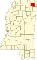
| State | Mississippi |
| County | Prentiss |
| Elevation | 440 ft (134 m) |
| Time zone | UTC-6 (Central (CST)) |
| • Summer (DST) | UTC-5 (CDT) |
| Area code | 662 |
| GNIS feature ID | 666239 [1] |
Altitude is an unincorporated community in eastern Prentiss County, Mississippi, United States, [1] about 7.1 miles from downtown Booneville, with a population of less than 100. Children in the area attend schools in the Prentiss County School District.
A post office operated under the name Altitude from 1888 to 1906. [2]