Jumpertown, Mississippi

Last updated

Jumpertown, Mississippi
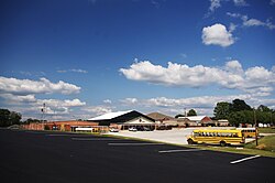
Jumpertown-school-ms.jpg
Jumpertown High School
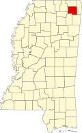
Prentiss County Mississippi Incorporated and Unincorporated areas Jumpertown Highlighted.svg
Location of Jumpertown, Mississippi
Usa edcp location map.svg
Red pog.svg
Jumpertown, Mississippi
Location in the United States
Coordinates: 34°42′36″N88°39′26″W / 34.71000°N 88.65722°W / 34.71000; -88.65722
Country United States
State Mississippi
County Prentiss
Area
[1]
  Total1.79 sq mi (4.63 km2)
  Land1.79 sq mi (4.63 km2)
  Water0.00 sq mi (0.00 km2)
Elevation
584 ft (178 m)
Population
 (2020)
  Total425
  Density237.56/sq mi (91.74/km2)
Time zone UTC-6 (Central (CST))
  Summer (DST) UTC-5 (CDT)
ZIP code
38829
Area code 662
FIPS code 28-37040
GNIS feature ID0672053

Jumpertown is a town in Prentiss County, Mississippi, United States. The population was 480 at the 2010 census.

Contents

History

On November 5, 1862, there was a civil war skirmish in Jumpertown. [2] In November 1886, the Mississippi state meeting of the Agricultural Wheel, a forerunner of 19th century American populism, met in Jumpertown. [3]

Geography

Jumpertown is located at 34°42′36″N88°39′26″W / 34.71000°N 88.65722°W / 34.71000; -88.65722 (34.710127, -88.657319). [4]

According to the United States Census Bureau, the town has a total area of 1.8 square miles (4.7 km2), of which 1.8 square miles (4.7 km2) is land and 0.55% is water.

Demographics

Historical population
CensusPop.Note
1980 472
1990 438−7.2%
2000 404−7.8%
2010 48018.8%
2020 425−11.5%
U.S. Decennial Census [5]

As of the census [6] of 2000, there were 404 people, 168 households, and 119 families residing in the town. The population density was 223.7 inhabitants per square mile (86.4/km2). There were 173 housing units at an average density of 95.8 per square mile (37.0/km2). The racial makeup of the town was 97.77% White, 1.73% African American, and 0.50% from two or more races. Hispanic or Latino of any race were 2.72% of the population.

There were 168 households, out of which 39.9% had children under the age of 18 living with them, 48.8% were married couples living together, 17.9% had a female householder with no husband present, and 28.6% were non-families. 27.4% of all households were made up of individuals, and 14.9% had someone living alone who was 65 years of age or older. The average household size was 2.40 and the average family size was 2.92.

In the town, the population was spread out, with 28.5% under the age of 18, 8.9% from 18 to 24, 28.2% from 25 to 44, 22.8% from 45 to 64, and 11.6% who were 65 years of age or older. The median age was 33 years. For every 100 females, there were 89.7 males. For every 100 females age 18 and over, there were 79.5 males.

The median income for a household in the town was $21,471, and the median income for a family was $25,000. Males had a median income of $19,464 versus $20,446 for females. The per capita income for the town was $12,122. About 25.4% of families and 24.5% of the population were below the poverty line, including 30.8% of those under age 18 and 32.3% of those age 65 or over.

Education

Jumpertown is served by the Prentiss County School District.

Related Research Articles

<span class="mw-page-title-main">Union County, Mississippi</span> County in Mississippi, United States

Union County is a county located in the U.S. state of Mississippi. It was formed in 1870 from Tippah and Pontotoc counties, and in 1874 a portion of Lee County was added. As of the 2020 census, the population was 27,777. Its county seat is New Albany. According to most sources, the county received its name by being a union of pieces of several large counties, like other Union counties in other states. However, other sources say that the name was meant to mark the re-union of Mississippi and the other Confederate states after the Civil War.

<span class="mw-page-title-main">Tippah County, Mississippi</span> County in Mississippi, United States

Tippah County is a county located on the northern border of the U.S. state of Mississippi. As of the 2020 census, the population was 21,815. Its county seat is Ripley. The name "Tippah" is derived from a Chickasaw language word meaning "cut off." It was taken from the creek of the same name that flows across much of the original county from northeast to southwest before emptying into the Tallahatchie River. The creek probably was so named because it, and the ridges on either side, "cut off" the western part of the region from the eastern portion.

<span class="mw-page-title-main">Prentiss County, Mississippi</span> County in Mississippi, United States

Prentiss County is a county located in the U.S. state of Mississippi. As of the 2020 census, the population was 25,008. Its county seat is Booneville. The county is named for Seargent Smith Prentiss, a noted speaker and US Congressman from Natchez.

<span class="mw-page-title-main">Lee County, Mississippi</span> County in Mississippi, United States

Lee County is a county in U.S. state of Mississippi. At the 2020 census, the population was 83,353. Lee County is included in the Tupelo Micropolitan Statistical Area.

<span class="mw-page-title-main">Itawamba County, Mississippi</span> County in Mississippi, United States

Itawamba County is a county located in the U.S. state of Mississippi. As of the 2020 United States Census, the population was 23,863. Its county seat is Fulton. The county is part of the Tupelo, MS Micropolitan Statistical Area.

<span class="mw-page-title-main">Alcorn County, Mississippi</span> County in Mississippi, United States

Alcorn County is a county located in the northeastern portion of the U.S. state of Mississippi. As of the 2020 census, the population was 34,740. Its county seat is Corinth. The county is named in honor of Governor James L. Alcorn.

<span class="mw-page-title-main">Winstonville, Mississippi</span> Town in Mississippi, United States

Winstonville is a town in Bolivar County, Mississippi, United States. Per the 2020 census, the population was 153.

<span class="mw-page-title-main">Ackerman, Mississippi</span> Town in Mississippi, United States

Ackerman is a town in Choctaw County, Mississippi, United States. The population was 1,594 at the 2020 census, up from 1,510 at the 2010 census. It is the county seat of Choctaw County.

<span class="mw-page-title-main">Bassfield, Mississippi</span> Town in Mississippi, United States

Bassfield is a town in Jefferson Davis County, Mississippi, United States. The population was 192 at the 2020 census, down from 254 at the 2010 census.

<span class="mw-page-title-main">Prentiss, Mississippi</span> Town in Mississippi, United States

Prentiss is a town in Jefferson Davis County, Mississippi. The population was 1,081 at the 2010 census, down from 1,158 at the 2000 census. It is the county seat.

<span class="mw-page-title-main">De Kalb, Mississippi</span> Town in Mississippi, United States

De Kalb is a town in and the county seat of Kemper County, Mississippi, United States. The population was 1,164 at the 2010 census. De Kalb is named after General Johann de Kalb, a Franconian-French military officer who served as a major general in the Continental Army during the American Revolutionary War.

<span class="mw-page-title-main">Plantersville, Mississippi</span> Town in Mississippi, United States

Plantersville is a town in Lee County, Mississippi. The population was 868 at the 2020 census.

<span class="mw-page-title-main">Booneville, Mississippi</span> City in Mississippi, United States

Booneville is a city in the U.S. state of Mississippi and is the county seat of Prentiss County. It is located in the hilly North Mississippi region, and ecologically is part of the Southeastern Plains region.

<span class="mw-page-title-main">Marietta, Mississippi</span> Town in Mississippi, United States

Marietta is a town in Prentiss County, Mississippi, United States. The population was 248 at the 2000 census.

<span class="mw-page-title-main">Walnut, Mississippi</span> Town in Mississippi, United States

Walnut is a town in Tippah County, Mississippi, United States. The population was 771 at the 2010 census.

<span class="mw-page-title-main">Mantachie, Mississippi</span> Town in Mississippi, United States

Mantachie is a town in Itawamba County, Mississippi, United States. The population was 1,121 in the 2020 census. It is located 14 miles (23 km) northeast of Tupelo at the intersection of Mississippi Highways 363 and 371 and 5 miles (8 km) north of Interstate 22.

<span class="mw-page-title-main">Oliver, Wisconsin</span> Village in Wisconsin, United States

Oliver is a village in Douglas County, Wisconsin, United States. The population was 423 at the 2020 census.

<span class="mw-page-title-main">Bern, Wisconsin</span> Town in Wisconsin, United States

Bern is a town in Marathon County, Wisconsin, United States. It is part of the Wausau, Wisconsin Metropolitan Statistical Area. The population was 591 at the 2010 census. The unincorporated community of Gad is located partially in the town.

<span class="mw-page-title-main">State Line, Mississippi</span> Town in Mississippi, United States

State Line is a town in Greene and Wayne counties, Mississippi, in the United States. The population was 452 at the 2020 census.

<span class="mw-page-title-main">Nettleton, Mississippi</span> Town in Mississippi, United States

Nettleton is a town in Lee and Monroe counties in Mississippi. The population was 1,935 at the 2020 census. Incorporated in 1888, the town was named after George Henry Nettleton, president of the Kansas City, Memphis and Birmingham Railroad (KCM&B).

References

  1. "2020 U.S. Gazetteer Files". United States Census Bureau. Retrieved July 24, 2022.
  2. United States. War Dept; Robert Nicholson Scott (1886). The War of the Rebellion: Formal reports, both Union and Confederate, of the first seizures of United States property in the Southern States (53 v. in 111). Historical Times. p. 465. Retrieved January 5, 2013.
  3. W. Scott Morgan (1891). History of the Wheel and Alliance and the impending revolution. C.B. Woodward. p.  75 . Retrieved January 5, 2013.
  4. "US Gazetteer files: 2010, 2000, and 1990". United States Census Bureau. February 12, 2011. Retrieved April 23, 2011.
  5. "Census of Population and Housing". Census.gov. Retrieved June 4, 2015.
  6. "U.S. Census website". United States Census Bureau . Retrieved January 31, 2008.