
Alton is a town within the locality of St George in the Shire of Balonne, Queensland, Australia. [1] As at 2018, it is completely covered in bushland and there are no buildings or evidence of the roads shown on the town map. [2]
Alton is a town within the locality of St George in the Shire of Balonne, Queensland, Australia. [1] As at 2018, it is completely covered in bushland and there are no buildings or evidence of the roads shown on the town map. [2]
Alton is located to the south of the Moonie River and north of the Moonie Highway. The Alton National Park is to the south-east of the town. [2]
Alton first appears on an 1883 survey plan. [1] In March 1884 town and suburban lots in Alton were offered for sale, described as on the Moonie River and 46 miles (74 km) east of St George. [3] In January 1885, the Queensland Government gazetted a camping reserve to the west of the town. [4]
As at October 2018, there is no evidence that any development occurred in the town. [2]
Alton is a national park in the Balonne Shire local government area of South West Queensland, Australia.

St George is a rural town and locality in the Shire of Balonne, Queensland, Australia. It is the administrative centre for the Shire of Balonne. In the 2021 census, St George had a population of 3,130 people.

Hebel is a rural town and locality in the Shire of Balonne, Queensland, Australia. It is on the border of Queensland and New South Wales. In the 2021 census, the locality of Hebel had a population of 62 people.
Dirranbandi is a rural town and locality in the Shire of Balonne, Queensland, Australia. The locality is on the border of Queensland with New South Wales. In the 2021 census, the locality of Dirranbandi had a population of 610 people.

The Balonne Highway, a state highway of Queensland, is the continuation westward of State Route 49 from the town of St George to its termination at Cunnamulla. There are no large settlements between St George and Cunnamulla.

Mungindi is a town and locality on the border of New South Wales (NSW) and Queensland, Australia. The town is within Moree Plains Shire in New South Wales. Within Queensland, the locality is split between the Shire of Balonne and the Goondiwindi Region with the town in the Shire of Balonne. It possesses a New South Wales postcode. Mungindi sits on the Carnarvon Highway and straddles the Barwon River which is the border between New South Wales and Queensland. At the 2016 census, Mungindi had a population of 601 on the New South Wales side, while the population on the Queensland side was 146.

Surat is a rural town and locality in the Maranoa Region, Queensland, Australia. In the 2021 census, the locality of Surat had a population of 402 people.

The Moonie Highway is a state highway of Queensland, Australia. Part of State Route 49, it leaves the Warrego Highway at Dalby and runs for over 290 km until it reaches St George. From there, State Route 49 continues west as the Balonne Highway. From Dalby, it continues north-east as the Bunya Highway.

The Shire of Balonne is a local government area in South West Queensland, Australia, over 500 kilometres (310 mi) from the state capital, Brisbane. It covers an area of 31,104 square kilometres (12,009.3 sq mi), and has existed as a local government entity since 1879. It is headquartered in its main town, St George.

The Shire of Cloncurry is a local government area in North West Queensland, Australia. It covers an area of 47,971 square kilometres (18,521.7 sq mi), and has existed as a local government entity since 1884. The major town and administrative centre of the shire is Cloncurry.
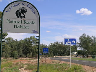
Bollon is a rural town and locality in the Shire of Balonne, Queensland, Australia. In the 2021 census, the locality of Bollon had a population of 174 people.

Thallon is a town and a locality in the Shire of Balonne, Queensland, Australia. In the 2021 census, the locality of Thallon had a population of 231 people.

Moonie is a rural town in the Western Downs Region and a locality split between the Western Downs Region and the Goondiwindi Region in Queensland, Australia. In the 2021 census, the locality of Moonie had a population of 182 people.

The Moonie River (Mooni River) is a river in Shire of Balonne, Queensland and Walgett Shire, New South Wales, both in Australia. It is a perennial river of the Barwon catchment within the Murray–Darling basin.
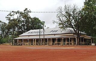
Nindigully is a rural town within the locality of Thallon in the Shire of Balonne, Queensland, Australia.
The Andrew Nixon Bridge is a road bridge over the Balonne River in St George, Queensland, Australia. The bridge, which is part of the Balonne Highway, is the only river crossing in the area.

South West Queensland is a remote region in the Australian state of Queensland which covers 319,808 km2 (123,479 sq mi). The region lies to the south of Central West Queensland and west of the Darling Downs and includes the Maranoa district and parts of the Channel Country. The area is noted for its cattle grazing, cotton farming, opal mining and oil and gas deposits.
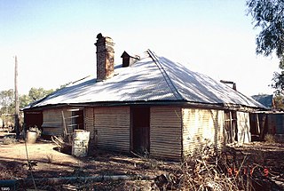
Bullamon Homestead is a heritage-listed homestead at Moonie River, Thallon, Shire of Balonne, Queensland, Australia. It was built from 1860s circa to 1880s circa. It is also known as Gerar. It was added to the Queensland Heritage Register on 2 June 1996.
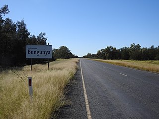
Bungunya is a rural town and locality in the Goondiwindi Region, Queensland, Australia. The locality is on the border of Queensland and New South Wales. In the 2021 census, the locality of Bungunya had a population of 62 people.

Weengallon is a rural locality in the Goondiwindi Region, Queensland, Australia. In the 2021 census, Weengallon had a population of 46 people.