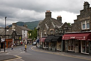
Ambleside is a town and former civil parish in the Westmorland and Furness district of Cumbria, England. Within the boundaries of the historic county of Westmorland and located in the Lake District National Park, the town sits at the head of Windermere, England's largest natural lake. In 2020 it had an estimated population of 2596.
Ferntree Gully is a suburb in Melbourne, Victoria, Australia, at the foothills of the Dandenong Ranges, 27 km east of Melbourne's Central Business District, located within the City of Knox local government area. Ferntree Gully recorded a population of 27,398 at the 2021 census.

The Town of Victoria Park is a local government area of Western Australia. It covers an area of 17.62 km² in metropolitan Perth, the capital of Western Australia. It had a population of approximately 35,000 as at the 2016 census.

The Shire of Augusta Margaret River is a local government area in the south-west corner of the South West region of Western Australia, approximately 270 kilometres (168 mi) south of Perth. The shire covers an area of 2,243 square kilometres (866 sq mi) and had a population of over 14,000 at the 2016 Census, about half of whom live in the towns of Margaret River and Augusta.

Hahndorf is a small town in the Adelaide Hills region of South Australia. Currently an important tourism spot, it has previously been a centre for farming and services.
Largs North is a suburb in the Australian state of South Australia located on the Lefevre Peninsula in the west of Adelaide about 17 kilometres (11 mi) northwest of the Adelaide city centre.

Largs Bay is a suburb in the Australian state of South Australia located on the Lefevre Peninsula in the west of Adelaide about 16 kilometres (9.9 mi) northwest of the Adelaide city centre.
Birkenhead is a north-western suburb of Adelaide 14 km from the CBD, on the Lefevre Peninsula, in South Australia, and lies within the City of Port Adelaide Enfield. It is adjacent to Peterhead, Exeter and Glanville. It is bounded to the south by the Gawler Reach of the Port River, to the north by Hargrave Street and in the west and east by the Outer Harbor railway line and the Port River respectively.
Coodanup is a south-eastern suburb of Mandurah, Western Australia. Its local government area is the City of Mandurah.

Banora Point is a suburb located in the Northern Rivers region of New South Wales, Australia in Tweed Shire. Together with Tweed Heads South and Terranora it had a combined population of 27,368 in 2001, including 21,457 (78.4%) Australian-born persons and 525 (1.9%) indigenous persons. In the 2016 census, Banora Point had a population of 16,167.

Ambleside Roman Fort is the modern name given to the remains of a fort of the Roman province of Britannia. The ruins have been tentatively identified as Galava, mentioned in the Antonine Itinerary. Dating to the 1st or 2nd century AD, its ruins are located on the northern shore of Windermere at Waterhead, near Ambleside, in the English county of Cumbria, within the boundaries of the Lake District National Park.

Belmont is a suburb of Perth, the capital city of Western Australia, and is located 7 kilometres (4 mi) east of Perth's central business district (CBD) on the southern bank of the Swan River. Its local government area is the City of Belmont.
Lakelands is a residential suburb of the City of Lake Macquarie, New South Wales, Australia 16 kilometres (10 mi) south-west of Newcastle's central business district near the northern end of Lake Macquarie. It is part of the City of Lake Macquarie west ward, and was formerly part of Warners Bay.
Invermay is a residential locality in the local government area (LGA) of Launceston in the Launceston LGA region of Tasmania. The locality is about 3 kilometres (1.9 mi) north of the town of Launceston. The 2021 census recorded a population of 3,498 for the state suburb of Invermay. It is a suburb of Launceston, which contains the minor suburb of Inveresk, it is located on the eastern side of the Tamar River and the northern side of the North Esk River, the suburb is most notable as being home to York Park.

The Shire of Jerramungup is a local government area in the Great Southern region of Western Australia, about 180 kilometres (112 mi) northeast of Albany and about 440 kilometres (273 mi) southeast of the state capital, Perth. The Shire covers an area of 6,507 square kilometres (2,512 sq mi) with Bremer Bay its largest town. The seat of government is the town of Jerramungup.
Woorree is an eastern suburb of Geraldton, Western Australia. Its local government area is the City of Greater Geraldton.
Ambleside railway station was located about 43.5 kilometres from Adelaide station, on the Adelaide-Wolseley line, in the Adelaide Hills suburb of Balhannah, at an elevation of 318 metres.

Keralup is a suburb straddling the southern boundary of the metropolitan area of Perth, Western Australia, on the eastern side of the Kwinana Freeway, and consists entirely of a government strategic landholding. The suburb will ultimately contain 90,000 people, with the majority of development being on the eastern side of the Serpentine River.
College Grove is a suburb on the southern outskirts of Bunbury, Western Australia. Within the suburb there is the Bunbury Regional Hospital and St. John of God Bunbury Hospital on the South West Health Campus. The Edith Cowan University Bunbury Campus and South West Institute of Technology are also within College Grove.
Gabbadah is a locality within the Shire of Gingin, located around 30 km north of Perth metropolitan area's northern limit.

