Anabta | |
---|---|
Arabic transcription(s) | |
• Arabic | عنبتا |
• Latin | 'Anabta (official) 'Anabta and Iktaba (unofficial) |
![]() View of Anabta | |
Location of Anabta within Palestine | |
Coordinates: 32°18′26″N35°07′01″E / 32.30722°N 35.11694°E | |
Palestine grid | 161/190 |
State | State of Palestine |
Governorate | Tulkarm |
Government | |
• Type | Municipality |
• Head of Municipality | Hamdallah. H. Hamdallah |
Population (2017) | |
• Total | 8,077 |
Name meaning | grapes [1] |
Anabta (Arabic : عنبتا) is a Palestinian town in the Tulkarm Governorate in the northern West Bank, located 9 kilometers east of Tulkarm. According to the Palestinian Central Bureau of Statistics, Anabta had a population of 8,077 inhabitants in 2017. [2] Anabta is administered by a municipal council and is one of the oldest municipalities in the Tulkarm Governorate. [3]
The name is derived from the word Enabta, which meant "grape" or "berry" in Aramaic and Syriac. [4] Many grape presses have been found in the hills around the village. [3]
Sherds from the Hellenistic, early and late Roman and the Byzantine eras have been found here. [5]
During Roman and Byzantine rule, Anabta was a Samaritan village. [6] A tradition connects the village with Dositheos, a Samaritan religious leader possibly active during the 1st century CE. [5] The Samaritan chronicler Abu l-Fath (14th century) mentions that Dositheos died of starvation after going to 'Anbata where he hid in a cave, fasting in an effort to gain wisdom. [7] Some olive trees still existing in Anabta are said to date back to Roman times.
According to the PEF's Survey of Western Palestine , the site appeared "ancient", [8] and rock-cut tombs and a tank of good masonry had been found. [9] [10]
Pottery sherds from the early Muslim and Medieval eras have also been found here. [5]
During the reign of Mamluk Sultan Baibars al-Bunduqdari in the 13th century, Anabta served as a central staging point from which to supply the Muslim armies fighting Crusader and Mongol incursions. The location was chosen because it was considered relatively easy to protect as the area is nestled between two large hills. [3]
During Ottoman rule, Anabta was listed in the 1596 Ottoman tax register as being in the Nahiya of Jabal Sami of the Liwa of Nablus. It had a population of 55 Muslim households who paid a fixed tax rate of 33,3% on wheat, barley, summer crops, olives, goats or beehives, and presses for grapes or olives; a total of 13,757 akçe. [11]
In 1852, the American scholar Edward Robinson visited the village. He described it as "large and well built", with two watermills by the stream. There were many camels there, as the village was on the main route for camels from Nablus to Ramleh. [12]
In 1870/1871 (1288 AH), an Ottoman census listed the village in the nahiya (sub-district) of Wadi al-Sha'ir. [13]
In 1882, the PEF's Survey of Western Palestine described it as a village of moderate size, in the valley, with olives around it. It also had a mill. [8] A portion of the Hejaz Railway used to run through the centre of the town, parallel to the main street. [3]
The first local council in Anabta was established in 1922 during the mandate period. [14] [15] In the 1936 Anabta shooting, on the night of April 15, 1936, a prelude to the 1936–39 Arab revolt in Palestine, about 20 vehicles traveling on the road outside Anabta were stopped at a road block constructed for the purpose by armed villagers, and forced to hand over weapons and cash. 3 Jewish drivers were separated from the non-Jewish drivers and shot, 2 died of their injuries, the third survived. [16] [17] In June, an attack by Arab irregulars on a civilian bus convoy escalated into the Battle of Anabta, a brief but intense fight between Arab militants and the British army involving air attacks on the Arab fighters. [18] On October 12, 1936, when the rebellion stopped, the Daily Telegraph reporter described the village during his visit to it, he said: "Anabta, the scene of several encounters between British troops and Arabs, was the only place through which I passed where the inhabitants showed truculence". [19]
In the wake of the 1948 Arab–Israeli War, and after the 1949 Armistice Agreements, Anabta came under Jordanian rule.
In 1954, Anabta became a municipal council. [3]
In 1961, the population of Anabta was 4,018. [20]
Since the Six-Day War in 1967, Anabta has been under Israeli occupation. Shortly after the war, Anabta underwent major development and achieved local council status. [21] According to Israel's Ministry of Defense, the village was connected to the Israeli electric grid. [22] Anabta lies on the edge of the Tulkarm district's Area A, a Palestinian enclave, which means the city became under full security and civil jurisdiction of the Palestinian National Authority.[ citation needed ]
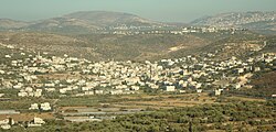
Anabta is located 19 kilometers west of Nablus and 9 kilometers east of Tulkarm. The town is bordered to the north by the village of Kafr Rumman, the south by the town of Kafr al-Labad, the east by the village of Ramin and the northwest by the town of Bal'a. The city is elevated 150 meters above sea level. [3] [23] Surrounded by hills on all sides, a small valley that runs through the center of the town. [3] The town has an urban area of about 1,300 dunams. Most of its exterior lands are planted with olives, figs and almonds or covered by forests. Water is provided by five underground wells, with distribution supervised by the town's municipality. [24] The Israeli settlement Einav is located southeast of the city and an Israeli checkpoint is positioned at the eastern entrance of the town. [25]
By an 1870 visitor, the population was estimated at 1,800. [26] At the time of the 1922 census of Palestine, Anabta had a population of 1,606 Muslims. [27] In the 1931 census of Palestine, the combined population of Anabta, Iktaba and Nur ash Shams was 2498; 2,457 Muslims, 34 Christians and 1 Druze living in 502 houses. [28] In 1945, the combined population of Anabta and Iktaba was 3,120. [29] [30] Between 1922 and 1947, the population increased by 110%. [31]
In 1967, the population was 3,400, rising to 5,700 by 1987 and 8,300 by 2009. [24]
Residents of Anabta belong to two large clans, 'Amr and Al-Jetawi. These families are then divided into smaller families. [32] Residents of the village have origins in Hebron, Kafr ad-Dik and other locations. [33] Anabta also contains a significant population of Palestinians from Gaza who are not classified among the families.
The town has two high schools and four elementary schools that are maintained and funded by the Palestinian Authority Ministry of Education. [3]
The St John of Jerusalem Eye Hospital Group operates a clinic in Anabta envisaged as a centre for the treatment of diabetic retinopathy in the northern West Bank. [34]
Tulkarm or Tulkarem is a Palestinian city in the West Bank, the capital of the Tulkarm Governorate of the State of Palestine. The Israeli city of Netanya is to the west, and the Palestinian cities of Nablus and Jenin to the east. According to the Palestinian Central Bureau of Statistics, in 2017 Tulkarm had a population of 64,532. Tulkarm is under the administration of the Palestinian National Authority.
Kafr Jammal, is a Palestinian town in the Tulkarm Governorate in the western edge of the West Bank. It is located about halfway between Qalqilyah and Tulkarm, and had a population of 2,855 in 2017. The village is mainly agricultural, and mostly raises olive and citrus crops. Kafr Jammal is at an altitude of 257 meters, and is bordered by Falamya in the west, Kafr Zibad in the east, Jayyous in the south, and Kafr Sur to the north.
Kafr 'Abbush is a Palestinian town in the Tulkarm Governorate in the northwestern West Bank. According to the Palestinian Central Bureau of Statistics, Kafr 'Abbush had a population of approximately 1,488 inhabitants in mid-year 2006 and 1,739 by 2017. 24.8% of the population of Kafr 'Abbush were refugees in 1997. The healthcare facilities for Kafr 'Abbush are based in Kafr 'Abbush, where the facilities are designated as MOH level 2.
Iktaba is a Palestinian town located four kilometers Northeast of the city of Tulkarm in the Tulkarm Governorate in the northern West Bank. According to the Palestinian Central Bureau of Statistics (PCBS), the town had a population of 2,665 inhabitants in 2007 and 2,997 by 2017. Refugees make-up 33% of the entire population in 1997.
Deir Ballut is a Palestinian town in the Salfit Governorate in the northern West Bank, 41 kilometers (25 mi) south west of Nablus. According to the Palestinian Central Bureau of Statistics, it had a population of 3,873 in 2017.
Kafr Thulth is a Palestinian town located on high, flat land south of Azzoun, 28 kilometers (17 mi) south of Tulkarm in the Qalqilya Governorate. The average elevation is 270 meters (890 ft) above sea level. According to the Palestinian Central Bureau of Statistics, the town's population was 5,606 in the 2017 census.
Bruqin is a Palestinian town 13 kilometers west of Salfit in the Salfit Governorate of the State of Palestine, in the northern West Bank, adjacent to the Israeli settlement of Brukhin, which was built over lands confiscated from the Palestinian town. According to the Palestinian Central Bureau of Statistics, Bruqin had a population of 4,047 in 2017. The town used to be on a camel-trading route. There is evidence of Roman rule in the city due to the presence of three ancient pools and a tomb.
Bal'a is a Palestinian town in the Tulkarm Governorate, located approximately nine kilometers northeast of Tulkarm in the northern West Bank and three kilometers away from the highway connecting Tulkarm with Nablus.
Kafr al-Labad is a Palestinian village in the Tulkarm Governorate in the northeastern West Bank, located 9 kilometers east of Tulkarm and two kilometers south of Anabta. Its population in 2017 was 4,747 according to the Palestinian Central Bureau of Statistics. It has a total land area of 11,917 dunams, of which 25% is used for agricultural purposes. The town's main agricultural products are olives, fruits and wheat.
Attil is a Palestinian town in the Tulkarm Governorate in the eastern West Bank, 12 km (7.5 mi) northeast of Tulkarm. Attil is the connection point between the other villages and Tulkarm. It is bordered by Illar to the east; Baqa ash-Sharqiyya to the north; The Green Line to the west; and Deir al-Ghusun to the south. Mountains surrounding the town include the Nabhan, Aboora, Asad, and Shehadeh mountains. Attil has an elevation of 100 m (330 ft) above Sea level, and an area of 7.337 km2.
Kafr Rumman is a Palestinian town in the Tulkarm Governorate in the eastern West Bank, located 11 kilometers East of Tulkarm. According to the Palestinian Central Bureau of Statistics, Kafr Rumman had a population of approximately 869 inhabitants in mid-year 2007.
Kafr Sur is a Palestinian town in the Tulkarm Governorate in the eastern West Bank, located 12 kilometers Southeast of Tulkarm. According to the Palestinian Central Bureau of Statistics, Kafr Sur had a population of approximately 1,254 inhabitants in mid-year 2006, and 1,288 by 2017. 13.5% of the population of Kafr Sur were refugees in 1997.
Qabalan is a Palestinian town in the Nablus Governorate in the eastern West Bank, located 19 kilometers (12 mi) southeast of Nablus. According to the Palestinian Central Bureau of Statistics (PCBS), the town had a population of 8,195 inhabitants in 2017.
Baqa al-Hatab is a Palestinian village in the Qalqilya Governorate in the western area of the West Bank, located 20 kilometers southwest of Nablus. According to the Palestinian Central Bureau of Statistics, the village had a population of 1,943 inhabitants in 2017.
Jurish is a Palestinian town in Nablus Governorate in the northern West Bank, located 27 kilometers southeast of Nablus. According to the Palestinian Central Bureau of Statistics (PCBS), the town had a population of 1,541 inhabitants in 2017.
Kafr Zibad is a Palestinian village in the Tulkarm Governorate in the western part of the West Bank, located 17 kilometers south of Tulkarm.
Kur is a Palestinian village in the Tulkarm Governorate of the State of Palestine, in the northeastern West Bank, located 19 kilometers southeast of Tulkarm.
al-Ras is a Palestinian village in the Tulkarm Governorate in the eastern West Bank, located 7 kilometers South-east of Tulkarm. According to the Palestinian Central Bureau of Statistics, al-Ras had a population of 650 inhabitants in 2017. In 1997, refugees made up 11.1% of the population of al-Ras. The healthcare facilities for al-Ras are based in Kafr Sur, where the facilities are designated as MOH level 2.
Zeita is a Palestinian town in the Tulkarm Governorate in the western West Bank, located 11 kilometers North-east of Tulkarm. According to the Palestinian Central Bureau of Statistics, Zeita had a population of 3,078 inhabitants in 2017. 21.5% of the population of Zeita were refugees in 1997. The healthcare facilities for Zeita are designated as MOH level 2.
Azzun is a Palestinian town in Qalqilya Governorate in the northern West Bank, located 9 kilometers east of Qalqilya and 24 kilometers south of Tulkarm.
A number of casualties were reported from Palestine as clashes between Arabs and British troops occurred in the Tel Aviv region. The most serious occurrence was a battle at Anabta involving bombers.