Anjukunnu Anjukunnu | |
---|---|
village | |
Coordinates: 11°44′47″N76°02′29″E / 11.7463500°N 76.041490°E Coordinates: 11°44′47″N76°02′29″E / 11.7463500°N 76.041490°E | |
Country | ![]() |
State | Kerala |
District | Wayanad |
Population (2001) | |
• Total | 18,049 |
Languages | |
• Official | Malayalam, English |
Time zone | UTC+5:30 (IST) |
PIN | 670645 |
Telephone code | 04935 |
ISO 3166 code | IN-KL |
Vehicle registration | KL-72 |
Nearest city | Mananthavady |
Literacy | almost 100%% |
Lok Sabha constituency | Wayanad |
Vidhan Sabha constituency | Mananthavady |
Anjukunnu (or Anchukunnu) is a village in Wayanad district in the state of Kerala, India. [1]
As of 2001 [update] India census, Anjukunnu had a population of 18049 with 9167 males and 8882 females. [1]
Anjukunnu is the modern name of Payal Hills. Around Christian Era it was ruled by a Chera King by name ‘Vanjan’, a philanthropist. [2]
Anjukunnu aka Anchukunnu means five hills in Malayalam language. Anjukunnu is a village which has five hills:
A famous public library with A Grade of Kerala State Library Council (Reg. No. 12 MDY 2469), "Pothujana Grandhalayam" situated in Anjukunnu.
Anchukunnucan be accessed from Mananthavady or Kalpetta. The Periya ghat road connects Mananthavady to Kannur and Thalassery. The Thamarassery mountain road connects Calicut with Kalpetta. The Kuttiady mountain road connects Vatakara with Kalpetta and Mananthavady. The Palchuram mountain road connects Kannur and Iritty with Mananthavady. The road from Nilambur to Ooty is also connected to Wayanad through the village of Meppadi.
The nearest railway station is at Mysore and the nearest airports are Kozhikode International Airport-120 km, Bengaluru International Airport-290 km, and Kannur International Airport, 58 km.
We must travel 10 kilometres from Mananthavady, 24 kilometres from Kalpetta, 28 kilometres from Sulthan Bathery and 97 kilometres from Kozhikode to reach Anjukunnu.
Oorpally is a small village near Koyileri, Mananthavady on the banks of the river Kabini in the Wayanad district of Kerala state, south India.
Cherukottur is a village in Wayanad district in the state of Kerala, India.
Edavaka is a Grama Panchayath in the Wayanad district of the Kerala State, India.
Irulam is a village near Pulpally in Wayanad district in the state of Kerala, India.
Kanjirangad is a village in Wayanad district in the state of Kerala, India.
Kidanganad is a village in Wayanad district in the state of Kerala, India.
Kuppadithara is a village near Padinharethara in Wayanad district in the state of Kerala, India.
Nalloornad is a village near Mananthavady in Wayanad district in the state of Kerala, India.
Nenmeni is a village near Bathery in Wayanad district in the state of Kerala, India.
Noolpuzha is a village near Sulthan bathery in Wayanad district in the state of Kerala, India.
Padichira is a village near Pulpally in Wayanad district in the state of Kerala, India.
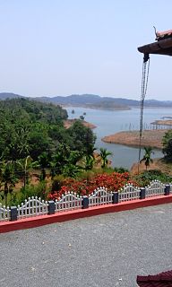
Padinharathara , padinharathara is a small town and important junction in Wayanad district in the state of Kerala, India.
Payyampally is a village in Wayanad district in the state of Kerala, India.
Poothadi is a village near Kenichira, Panamaram area in Wayanad district in the state of Kerala, India.
Porunnanore is a village near Tharuvana in Wayanad district in the state of Kerala, India.
Thalappuzha, Thavinhal or Thavinjal, is a village in Wayanad district in the state of Kerala, India. It is formally known as aranguthum chall, meaning the place for cultural programs.
Thirunelly is a village in Wayanad district in the state of Kerala, India.
Thomattuchal is a village in Wayanad district in the state of Kerala, India.
Thondernad is a village in Wayanad district in the state of Kerala, India.
Thrissilery is a village in Wayanad district in the state of Kerala, India.
![]() | This article related to a location in Wayanad district, Kerala, India is a stub. You can help Wikipedia by expanding it. |