Thomattuchal

Last updated

Thomattuchal
village
CountryFlag of India.svg  India
State Kerala
District Wayanad
Population (2001)
  Total17,744
Languages
  Official Malayalam, English
Time zone UTC+5:30 (IST)
PIN 6XXXXX
ISO 3166 code IN-KL
Vehicle registration KL-73

Thomattuchal is a village in Wayanad district in the state of Kerala, India. [1]

Wayanad district District in Kerala, India

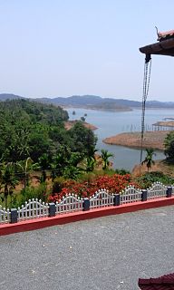
Wayanad is a district in the north-east of Kerala state, India with headquarters at the municipality of Kalpetta. It is set high on the Western Ghats with altitudes ranging from 700 to 2100. The district was formed on 1 November 1980 as the 12th district in Kerala by carving out areas from Kozhikode and Kannur districts. About 885.92.sq.km of area of the district is under forest. Wayanad has three municipal towns Kalpetta, Mananthavady and Sulthan Bathery. There are many indigenous tribals in this area.

Kerala State in southern India

Kerala is a state on the southwestern, Malabar Coast of India. It was formed on 1 November 1956, following passage of the States Reorganisation Act, by combining Malayalam-speaking regions. Spread over 38,863 km2 (15,005 sq mi), Kerala is the twenty second largest Indian state by area. It is bordered by Karnataka to the north and northeast, Tamil Nadu to the east and south, and the Lakshadweep Sea and Arabian Sea to the west. With 33,387,677 inhabitants as per the 2011 Census, Kerala is the thirteenth-largest Indian state by population. It is divided into 14 districts with the capital being Thiruvananthapuram. Malayalam is the most widely spoken language and is also the official language of the state.

India Country in South Asia

India, also known as the Republic of India, is a country in South Asia. It is the seventh largest country by area and with more than 1.3 billion people, it is the second most populous country and the most populous democracy in the world. Bounded by the Indian Ocean on the south, the Arabian Sea on the southwest, and the Bay of Bengal on the southeast, it shares land borders with Pakistan to the west; China, Nepal, and Bhutan to the northeast; and Bangladesh and Myanmar to the east. In the Indian Ocean, India is in the vicinity of Sri Lanka and the Maldives, while its Andaman and Nicobar Islands share a maritime border with Thailand and Indonesia.

Contents

Demographics

As of 2001 India census, Thomattuchal had a population of 17744 with 8727 males and 9017 females. [1]

Census Acquiring and recording information about the members of a given population

A census is the procedure of systematically acquiring and recording information about the members of a given population. The term is used mostly in connection with national population and housing censuses; other common censuses include agriculture, business, and traffic censuses. The United Nations defines the essential features of population and housing censuses as "individual enumeration, universality within a defined territory, simultaneity and defined periodicity", and recommends that population censuses be taken at least every 10 years. United Nations recommendations also cover census topics to be collected, official definitions, classifications and other useful information to co-ordinate international practice.

Transportation

Thomattuchal can be accessed from Sultan Battery. The Periya ghat road connects Mananthavady to Kannur and Thalassery. The Thamarassery mountain road connects Calicut with Kalpetta. The Kuttiady mountain road connects Vatakara with Kalpetta and Mananthavady. The Palchuram mountain road connects Kannur and Iritty with Mananthavady. The road from Nilambur to Ooty is also connected to Wayanad through the village of Meppadi.

The nearest railway station is at Mysore and the nearest airports are Kozhikode International Airport-120 km, Bengaluru International Airport-290 km, and Kannur International Airport, 58 km.

Kannur International Airport airport in India

Kannur International Airport is an international airport serving the district of Kannur, one of the northern districts in the state of Kerala, India. The airport spreads about 2,300 acres (930 ha). It is located 25 km (16 mi) east of the city, near the municipality of Mattannur. It is owned and operated by Kannur International Airport Limited(KIAL), a public–private consortium. The airport opened for commercial operations on 9 December 2018.

Related Research Articles

Kaniyambetta Village in Kerala, India

Kaniyambetta or Pachilakkad is a village in the Wayanad district of Kerala state, southern India. This places are mainly known as kamblakkad. Village office of kamblakkad is situated here.It is about 8 km from the district capital Kalpetta.

Anchukunnu village in Kerala, India

Anjukunnu is a village in Wayanad district in the state of Kerala, India.

Cherukottur is a village in Wayanad district in the state of Kerala, India.

Edavaka, Mananthavady Grama Panchayat in Kerala, India

Edavaka is a Gram Panchayat in the Wayanad district of the Kerala State, India.

Irulam village in Kerala, India

Irulam is a village near Pulpally in Wayanad district in the state of Kerala, India.

Kanjirangad is a village in Wayanad district in the state of Kerala, India.

Kidanganad village in Kerala, India

Kidanganad is a village in Wayanad district in the state of Kerala, India.

Kuppadithara is a village near Padinharethara in Wayanad district in the state of Kerala, India.

Nalloornad is a village near Mananthavady in Wayanad district in the state of Kerala, India.

Nenmeni village in Kerala, India

Nenmeni is a village near Bathery in Wayanad district in the state of Kerala, India.

Noolpuzha village in Kerala, India

Noolpuzha is a village near Sulthan bathery in Wayanad district in the state of Kerala, India.

Padichira village in Kerala, India

Padichira is a village near Pulpally in Wayanad district in the state of Kerala, India.

Padinharethara village in Kerala, India

Padinharethara , Padinjarethara or Padincharethara is a big town and important junction in Wayanad district in the state of Kerala, India.

Payyampally village in Kerala, India

Payyampally is a village in Wayanad district in the state of Kerala, India.

Poothadi village in Kerala, India

Poothadi is a village near Kenichira, Panamaram area in Wayanad district in the state of Kerala, India.

Porunnanore village in Kerala, India

Porunnanore is a village near Tharuvana in Wayanad district in the state of Kerala, India.

Thalappuzha, Wayanad village in Kerala, India

Thalappuzha, Thavinhal or Thavinjal, is a village in Wayanad district in the state of Kerala, India. It is formally known as aranguthum chall, meaning the place for cultural programs.

Thirunelly village in Kerala, India

Thirunelly is a village in Wayanad district in the state of Kerala, India.

Thondernad village in Kerala, India

Thondernad is a village in Wayanad district in the state of Kerala, India.

Thrissilery village in Kerala, India

Thrissilery is a village in Wayanad district in the state of Kerala, India.

References

  1. 1 2 "Census of India : Villages with population 5000 & above". Registrar General & Census Commissioner, India. Retrieved 2008-12-10.