
A geyser is a spring with an intermittent discharge of water ejected turbulently and accompanied by steam. The formation of geysers is fairly rare, and is caused by particular hydrogeological conditions that exist only in a few places on Earth.

Iceland is an island country at the confluence of the North Atlantic and Arctic oceans, east of Greenland and immediately south of the Arctic Circle, atop the constructive boundary of the northern Mid-Atlantic Ridge. The island country is the world's 18th largest in area and one most sparsely populated. It is the westernmost European country when not including Greenland and has more land covered by glaciers than continental Europe. Its total size is 103,125 km2 (39,817 sq mi) and possesses an exclusive economic zone of 751,345 km2 (290,096 sq mi).

Soda Springs is a city in Caribou County, Idaho, United States. Its population was 3,133 at the time of the 2020 census. The city has been the county seat of Caribou County since the county was organized in 1919. In the 1860s, Soda Springs served as the seat of Oneida County.

The Eifel is a low mountain range in western Germany, eastern Belgium and northern Luxembourg. It occupies parts of southwestern North Rhine-Westphalia, northwestern Rhineland-Palatinate and the southern area of the German-speaking Community of Belgium.

Geysir, sometimes known as The Great Geysir, is a geyser in south-western Iceland, that geological studies suggest started forming about 1150 CE. The English word geyser derives from Geysir. The name Geysir itself is derived from the Icelandic verb geysa. Geysir lies in the Haukadalur valley on the slopes of Laugarfjall lava dome, which is also the home to Strokkur geyser about 50 metres (160 ft) to the south. The Strokkur geyser may be confused with it, and the geothermal field it is in is known usually as either, Geysir or Haukadalur.
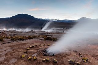
El Tatio is a geothermal field with many geysers located in the Andes Mountains of northern Chile at 4,320 metres (14,170 ft) above mean sea level. It is the third-largest geyser field in the world and the largest in the Southern Hemisphere. Various meanings have been proposed for the name "El Tatio", including "oven" or "grandfather". The geothermal field has many geysers, hot springs, and associated sinter deposits. These hot springs eventually form the Rio Salado, a major tributary of the Rio Loa, and are a major source of arsenic pollution in the river. The vents are sites of populations of extremophile microorganisms such as hyperthermophiles, and El Tatio has been studied as an analogue for the early Earth and possible past life on Mars.
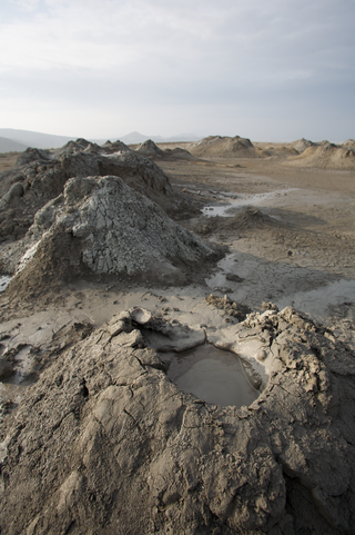
A mud volcano or mud dome is a landform created by the eruption of mud or slurries, water and gases. Several geological processes may cause the formation of mud volcanoes. Mud volcanoes are not true igneous volcanoes as they do not produce lava and are not necessarily driven by magmatic activity. Mud volcanoes may range in size from merely 1 or 2 meters high and 1 or 2 meters wide, to 700 meters high and 10 kilometers wide. Smaller mud exudations are sometimes referred to as mud-pots.

Andernach is a town in the district of Mayen-Koblenz, in Rhineland-Palatinate, Germany, of about 30,000 inhabitants. It is situated towards the end of the Neuwied basin on the left bank of the Rhine between the former tiny fishing village of Fornich in the north and the mouth of the small river Nette in the southeast, just 13 miles (21 km) north of Koblenz, with its five external town districts: Kell, Miesenheim, Eich, Namedy, and Bad Tönisstein.

Vembanad is the longest lake in India, as well as the largest in the state of Kerala. The lake has an area of 230 square kilometers and a maximum length of 96.5 km.

Crystal Geyser is a cold water, carbon dioxide driven geyser located on the east bank of the Green River approximately 9 miles (14 km) downstream from Green River, Utah, United States.

Middle Rhine is the section of the Rhine between Bingen and Bonn in Germany. It flows through the Rhine Gorge, a formation created by erosion, which happened at about the same rate as an uplift in the region, leaving the river at about its original level, and the surrounding lands raised. This gorge is quite deep, about 130 metres (430 ft) from the top of the rocks down to the average water-line.
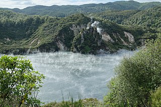
The Waimangu Volcanic Rift Valley is the hydrothermal system created on 10 June 1886 by the volcanic eruption of Mount Tarawera, on the North Island of New Zealand. It encompasses Lake Rotomahana, the site of the Pink and White Terraces, as well as the location of the Waimangu Geyser, which was active from 1900 to 1904. The area has been increasingly accessible as a tourist attraction and contains Frying Pan Lake, which is the largest hot spring in the world, and the steaming and usually pale blue Inferno Crater Lake, the largest geyser-like feature in the world although the geyser itself cannot be seen since it plays at the bottom of the lake.

Hunters Hot Springs are natural geothermal springs located in Lake County, Oregon, United States, 2 miles (3 km) north of Lakeview. The springs are named after Harry Hunter, who bought the springs in 1923. The best known feature within the geothermal area is Old Perpetual, which is Oregon's only continuously erupting geyser. The geyser was formed as a result of a well drilling attempt while Hunter was developing a health resort at the springs.
The Iceland Deep Drilling Project (IDDP) is a geothermal project established in 2000 by a consortium of the National Energy Authority of Iceland (Orkustofnun/OS) and four of Iceland's leading energy companies: Hitaveita Suðurnesja (HS), Landsvirkjun, Orkuveita Reykjavíkur and Mannvit Engineering. The consortium is referred to as "Deep Vision".

The Volcano Park in Mayen-Koblenz is a geopark in the rural district of Mayen-Koblenz in the eastern Vulkan Eifel, Germany. It was founded in 1996 and wraps around the Laacher See. Together with the Volcano Park, Brohltal/Laacher See and the Vulkan Eifel Nature and Geo-Park, it forms part of the national Eifel Volcano Land Geo-Park. The three parks are connected by the 280-kilometre-long German Volcano Route.
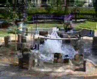
The Wallender Born or Wallenborn is a cold water geyser in the village Wallenborn. It is adjacent to the reactivated Andernach Geyser an active cold water geyser in Germany.
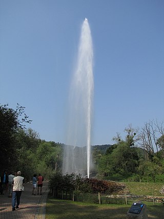
Cold-water geysers are geysers that have eruptions whose water spurts are propelled by CO2-bubbles, instead of the hot steam which drives the more familiar hot-water geysers: The gush of a cold-water geyser is identical to the spurt from a freshly-opened bottle of soda pop. Cold-water geysers look quite similar to their steam-driven counterparts; however, their CO2-laden water often appears whiter and more frothy.

Manitou Mineral Springs are natural mineral springs in Manitou Springs, Colorado and Cheyenne Spring House is on the National Register of Historic Places. The springs are located in one of the country's largest National Historic Districts.

Ice drilling allows scientists studying glaciers and ice sheets to gain access to what is beneath the ice, to take measurements along the interior of the ice, and to retrieve samples. Instruments can be placed in the drilled holes to record temperature, pressure, speed, direction of movement, and for other scientific research, such as neutrino detection.


