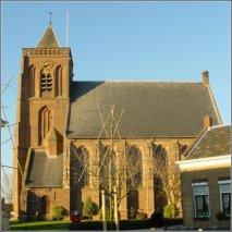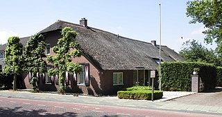
Benschop is a village in the Dutch province of Utrecht. It is a part of the municipality of Lopik, and lies about 4 km west of IJsselstein. Benschop is an extremely long village: apart from a relatively compact town centre, it consists of a long ribbon of houses on both sides of the Benschopsche Wetering. Until 1989, Benschop was a separate municipality.

Loenen aan de Vecht is a village in the Dutch province of Utrecht. It was the main village in the former municipality of Loenen. Since 2011 it has become part of the newly formed municipality of Stichtse Vecht. It lies about 10 km west of Hilversum.

Maarsbergen is a settlement in the Dutch province of Utrecht. It is a part of the municipality of Utrechtse Heuvelrug, and lies about 18 km east of Utrecht.

Vilsteren is a village in the municipality of Ommen in the Dutch province of Overijssel. It is situated just off the left bank of the Vecht in between Dalfsen and Ommen, about 17 kilometres east of the provincial capital of Zwolle.

Leerbroek is a village in the Dutch province of Utrecht. It is a part of the municipality of Vijfheerenlanden, and lies about 9 km (6 mi) northeast of Gorinchem.

Dussen is a village in the Dutch province of North Brabant. It is a part of the municipality of Altena, and is located about 12 km south of Gorinchem. Dussen Castle is located near the village.

Farmsum is a village in the Dutch province of Groningen. It is a part of the municipality of Eemsdelta.

Hoevelaken is a town in the Dutch province of Gelderland. It is a part of the municipality of Nijkerk, and lies about 5 km east of Amersfoort.

Kerk-Avezaath is a village in the Dutch province of Gelderland. It is a part of the municipality of Buren, and lies about 3 km west of Tiel.

Ophemert is a village in the Dutch province of Gelderland. It is a part of the municipality of West Betuwe, and lies about 5 km south of Tiel.

Nederhemert is a village in the Dutch province of Gelderland. It is a part of the municipality of Zaltbommel, and lies about 8 km southwest of that city. Nederhemert was a separate municipality until 1955, when it was merged with Kerkwijk.

Boven-Leeuwen is a village in the Dutch province of Gelderland. It is a part of the municipality of West Maas en Waal, and lies about 9 km east of Tiel. It is the protestant part of the former village of Leeuwen.

Deest is a village in the Dutch province of Gelderland. It is a part of the municipality of Druten, and lies about 9 km south of Wageningen.

Winssen is a village in the Dutch province of Gelderland. It is the smallest village of the municipality of Beuningen, and lies about 8 km north of Wijchen. It lies south of the river Waal

Wilp is a village in the Dutch province of Gelderland. It is located in the municipality of Voorst, about 4 km south of Deventer.

Glimmen is a village in the northeastern Netherlands. It is located in the municipality of Groningen, about 10 kilometres from the city. It had a population of around 1,342 in 2021. The river Drentsche Aa flows past the village, nearby the Huis te Glimmen, a stately home on the site.

Huis ter Heide is a village in the central Netherlands. It is located in the municipality of Zeist, Utrecht, about 2 km northeast of the centre of the town Zeist.

Ellecom is a village in the municipality of Rheden in the province of Gelderland, the Netherlands.

Giesbeek is a village in the municipality of Zevenaar in the province of Gelderland, the Netherlands.

Ooij is a village in the eastern Netherlands. It is located in the municipality of Berg en Dal, Gelderland.


