Antola Natural Regional Park

Last updated

Antola Natural Regional Park
Parco naturale regionale dell'Antola
IUCN category V (protected landscape/seascape)
Antola Est.JPG
Winter panorama from Monte Antola
Italy relief location map.jpg
Red pog.svg
Location Metropolitan City of Genoa, Italy
Nearest city Genova
Coordinates 44°34′26″N9°08′56″E / 44.574°N 9.149°E / 44.574; 9.149 Coordinates: 44°34′26″N9°08′56″E / 44.574°N 9.149°E / 44.574; 9.149
Area4,837 ha (11,950 acres)
Established1989, 1995
Governing bodyEnte Parco dell'Antola (Torriglia)
www.parcoantola.it

The Antola Natural Regional Park (in Italian Parco naturale regionale dell'Antola) is a natural park in Metropolitan City of Genoa (Liguria, Italy). It gets the name from the highest mountain of the area, Monte Antola.

Contents

History

Municipalities of the park (in red) Parco naturale regionale dell'Antola-mappa comuni.png
Municipalities of the park (in red)

The natural park was established by the l.r. (regional law, in Italian legge regionale ) nr. 16, April 9, 1985 as modified by the l.r. nr. 12, February 22, 1995. [1] Since April 30, 2014 the Environmental Management System of the park is certified according to ISO 14001 standards. [2]

Geography

Biurca, Rocche del Reopasso. Biurca.jpg
Biurca, Rocche del Reopasso.

Situated in the inland of the Italian Riviera between Genova and Rapallo, the park protects a scenic portion of the Ligurian Apennines. The protected area is mainly located near the border with Piemonte and south of the Apenninic watershed dividing Pianura Padana (tributary of the Adriatic Sea) from the Ligurian Sea drainage basin. It covers over 48 square kilometres [3] (that is 4,837 ha (11,950 acres)), plus 5,832 ha under a lesser form of environmental protection named aree contigue (contiguous areas).

The park encompasses the uppermost part of four short valleys:

Concerned municipalities

Zygaena ephialtes, a common moth in the Antola area Zygaenidae - Zygaena ephialtes.JPG
Zygaena ephialtes, a common moth in the Antola area
Beech trees near Monte Antola. Faggeta presso monte Antola.jpg
Beech trees near Monte Antola.

The natural park is shared among twelve different municipalities: Busalla, Crocefieschi, Fascia, Gorreto, Montebruno, Propata, Ronco Scrivia, Rondanina, Savignone, Torriglia, Valbrevenna, Vobbia. [3]

Main summits of the park

Castello della Pietra (lit. castle of the stone), an ancient castle of the park located not faraway from Vobbia. Castello della Pietra-vista dal sentiero.jpg
Castello della Pietra (lit. castle of the stone), an ancient castle of the park located not faraway from Vobbia.

Among the highest summits located in the park can be cited Monte Antola (1597 m), Monte Buio (1,497 m) and Monte Prelà (1406 m). Also relevant for some aspects are Rocche del Reopasso (956 m), a rocky summit with interesting climbing routes and a via ferrata, or Monte Reale (902 m), bearing an old Catholic sanctuary on its top and a free mountain hut all-year open next to the church. [4]

Wildlife

The most renowned among the animal species living in the park are wolves, that became extinct in the area around 1850 because of the increased number of inhabitants of that period. They reappeared around 150 years later coming from the central Apennine at the end of the 20th century, and are now an habitual presence in the protected area. They mostly prey on roe and fallow deer, which have also reappeared in the park in the last decades. Birds of prey are well represented by Buteo buteo, Accipiter nisus, Falco tinnunculus and Pernis apivorus. Quite common is the European green woodpecker and, close to the streams, Alcedo atthis (common kingfisher), while the population of red-legged partridge is shrinking due to the decreasing amount of farmland. [5]

Transport

Antola park can be reached by car via motorway (Autostrada A7, exits of Busalla, Ronco Scrivia or Isola del Cantone) or trunk road (S.S. 35 dei Giovi, S.S. 226 di Valle Scrivia and S.S. 45 di Val Trebbia). It is also linked to Genova by the scenic Genova-Casella narrow-gauge railway. [6]

Hiking

Lilium bulbiferum var. croceum, flowering in July Liliaceae - Lilium bulbiferum var. croceum-2.JPG
Lilium bulbiferum var. croceum, flowering in July

Around 270 km of footpaths, mostly signposted, are available within the park. The Rifugio Parco Antola, a mountain hut located at 1460 m near the summit of monte Antola, was built by the Ente Parco and is now managed by the Club Alpino Italiano. It can accommodate up to 32 hikers or alpinists. [7]

Related Research Articles

Busalla Comune in Liguria, Italy

Busalla is a comune (municipality) in the Metropolitan City of Genoa in the Italian region Liguria, located about 27 kilometres (17 mi) north of Genoa.

Crocefieschi Comune in Liguria, Italy

Crocefieschi is a comune (municipality) in the Metropolitan City of Genoa in the Italian region Liguria, located about 20 kilometres (12 mi) northeast of Genoa. Crocefieschi borders the following municipalities: Busalla, Savignone, Valbrevenna, Vobbia.

Ronco Scrivia Comune in Liguria, Italy

Ronco Scrivia is a comune (municipality) in the Metropolitan City of Genoa in the Italian region Liguria, located about 20 kilometres (12 mi) north of Genoa.

Torriglia Comune in Liguria, Italy

Torriglia is a comune (municipality) in the Metropolitan City of Genoa in the Italian region Liguria, located in the upper Trebbia valley, about 20 kilometres (12 mi) northeast of Genoa. Torriglia borders the following municipalities: Davagna, Lorsica, Lumarzo, Mocònesi, Montebruno, Montoggio, Neirone, Propata, Rondanina, Valbrevenna.

Vobbia Comune in Liguria, Italy

Vobbia is a comune (municipality) in the Metropolitan City of Genoa in the Italian region Liguria, located about 20 kilometres (12 mi) northeast of Genoa. Vobbia borders the following municipalities: Busalla, Carrega Ligure, Crocefieschi, Isola del Cantone, Mongiardino Ligure, Valbrevenna.

Monte Prelà mountain

Monte Prelà is a mountain in Liguria, northern Italy, part of the Ligurian Appennines.

Monte Antola mountain in the Apennin in Italy

Monte Antola is a mountain in Liguria, northern Italy, part of the Ligurian Appennines.

Monte Buio mountain in Italy

Monte Buio is a mountain in Liguria, northern Italy, part of the Ligurian Appennines. It is located between the provinces of Genoa and Alessandria. It lies at an altitude of 1400 metres.

Monte Reale mountain in Italy

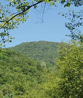
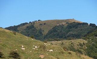
Monte Reale is a mountain of the Ligurian Apennines. It is located in the Province of Genoa along the watershed between the basin of the Scrivia Torrent and that of the Vobbia, its tributary to the right. It is situated in the more western part of the Regional Natural Park of Antola between the municipal territories of Ronco Scrivia and Isola del Cantone.

Monte Reixa mountain

Monte Reixa is a mountain in Liguria, northern Italy, part of the Ligurian Appennines.

<i>Alta Via dei Monti Liguri</i>

The Alta Via dei Monti Liguri is a long-distance waymarked hiking trail in the Italian region of Liguria. In about 440 kilometres (270 mi) and 44 day hikes, it runs through the arc formed by Ligurian Alps and Ligurian Apennines from Ventimiglia to Ceparana.

Metropolitan City of Genoa Metropolitan City in Liguria, Italy

The Metropolitan City of Genoa is one of the fourteen Metropolitan cities of Italy, located in the region of Liguria. Its capital is the city of Genoa. It replaced the Province of Genoa.

Cima Fontanaccia Mountain in the Apennines

Cima Fontanaccia is a 1153 metres high mountain in the Ligurian Apennines, in Italy.

Parco naturale regionale delle Alpi Liguri Nature reserve in Italy

The Alpi Liguri Natural Regional Park is a natural park in Province of Imperia. It was established in 2007 by the legge regionale nr.34 of 15/11/2007.

Parco naturale regionale del Beigua

The Beigua Natural Regional Park is a natural park located in province of Savona and the Metropolitan City of Genoa, both in Liguria (Italy). It's the largest protected area of the region. It gets the name from the highest mountain of the area, Monte Beigua.

Parco naturale delle Capanne di Marcarolo regional park in Italy

The Capanne di Marcarolo Natural Regional Park is a natural park in the province of Alessandria. It gets the name from a small village in the protected area, Capanne di Marcarolo.

Carmo di Brocchi Mountain in Italy

Carmo di Brocchi is a 1,610-metre (5,282 ft) mountain of the Ligurian Alps, in Italy.

Brevenna

The Brevenna is a 16.138-kilometre (10.028 mi) creek of Liguria, Italy.

Monte Antoroto Mountain in Italy

The Monte Antoroto is a mountain of the Ligurian Alps located in Piedmont.

References

  1. "Elenco ufficiale delle aree protette (EUAP) – 5º Aggiornamento – Supplemento ordinario n. 144 alla Gazzetta Ufficiale n. 205 del 4 settembre 2003" (PDF). www.parks.it. Ministero dell'ambiente e della tutela del territorio e del mare . Retrieved March 7, 2016.
  2. Environmental management system certification of the park in .pdf: www.parks.it
  3. 1 2 RAFL – Rapporto sullo Stato delle Foreste in Liguria 2008. Compagnia delle Foreste Srl and Regione Liguria. 2009. Retrieved March 7, 2016.
  4. "Rifugio di Monte Reale (902 mt)". www.parks.it. Retrieved March 19, 2016.
  5. Fabrizio Capecchi (1990). Un'isola fra i monti. Edizioni Croma. Retrieved March 12, 2016.
  6. "Facilities". www.parcoantola.it. Archived from the original on March 28, 2016. Retrieved March 19, 2016.
  7. "Rifugio Parco Antola". www.rifugioantola.com. Retrieved March 12, 2016.

Bibliography

Commons-logo.svg Media related to Parco naturale regionale dell'Antola at Wikimedia Commons