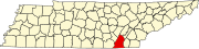
Marion County is a county located in the U.S. state of Tennessee. As of the 2020 census, the population was 28,837. Its county seat is Jasper. Marion County is part of the Chattanooga, AL–TN–GA Metropolitan Statistical Area. Marion County is in the Central time zone, while Chattanooga proper is in the Eastern time zone.

Chattanooga is a city in and the county seat of Hamilton County, Tennessee, United States. It is located along the Tennessee River, and borders Georgia to the south. With a population of 181,099 in 2020, it is Tennessee's fourth-most populous city and one of the two principal cities of East Tennessee, along with Knoxville. It anchors the Chattanooga metropolitan area, Tennessee's fourth-largest metropolitan statistical area, as well as a larger three-state area that includes Southeast Tennessee, Northwest Georgia, and Northeast Alabama.

Vinings is an unincorporated community and census-designated place (CDP) in Cobb County, Georgia, United States that runs along the Chattahoochee River bank across from Buckhead. As of the 2020 census, the CDP had a total population of 12,581. Located next to the affluent Paces section of Buckhead in northwest Atlanta, Vinings is known for its historic sites, shopping districts, proximity to local freeways and The Battery, and nearby nature areas. The United States Postal Service assigns "Atlanta" to the ZIP Code (30339) that includes Vinings.

North Decatur is an unincorporated community and census-designated place (CDP) in DeKalb County, Georgia, United States. The population was 18,511 in 2020.

Scottdale is an unincorporated community and census-designated place (CDP) in DeKalb County, Georgia, United States. The population was 10,698 in 2020.

Country Club Estates is an unincorporated community and census-designated place (CDP) in Glynn County, Georgia, United States. It is part of the Brunswick metropolitan statistical area. The population was 8,373 at the 2020 census, down from 8,545 in 2010.

Odenton is a census-designated place (CDP) in Anne Arundel County, Maryland, United States, located approximately 10–20 minutes from the state capital, Annapolis. The population was 37,132 at the 2010 census, up from 20,534 at the 2000 census. The town's population growth rate of 80.8% between 2000 and 2010 was the greatest of any town in western Anne Arundel County. Odenton is located west of Annapolis, south of Baltimore, and northeast of Washington, D.C..

West Laurel is an unincorporated area and census-designated place (CDP) in Prince George's County, Maryland, United States. Per the 2020 census, the population was 4,428.

Pine Bush is a hamlet located in the town of Crawford and adjacent to Shawangunk, New York, within Orange and adjacent to Ulster counties in the U.S. It is roughly coterminous with the 12566 ZIP code and 744 telephone exchange in the 845 area code. These both extend into adjacent regions of the town of Shawangunk in Ulster County.. The population was 1,751 at the 2020 census.
Collegedale is a city in Hamilton County, Tennessee, United States. The population was 11,109 at the 2020 census. Collegedale is a suburb of Chattanooga and is part of the Chattanooga, TN–GA Metropolitan Statistical Area. Collegedale is home to Southern Adventist University. The median household income is one of the highest in Hamilton County. It has been ranked as one of the best and safest places to live in Tennessee. The unincorporated community of Ooltewah is an enclave in Collegedale.
East Brainerd is an unincorporated community and former census-designated place (CDP) in Hamilton County, Tennessee, United States. The population was 14,132 at the 2000 census and was not recorded at the 2010 census. It is part of the Chattanooga, TN–GA Metropolitan Statistical Area.

East Ridge is a city in Hamilton County, Tennessee, United States. As of the 2020 census, the city population was 22,167. East Ridge is bordered by Chattanooga to the west, north, and east, and the Georgia state line to the south. It is part of the Chattanooga, TN–GA Metropolitan Statistical Area. The name of the city comes from its location due east of Missionary Ridge. The Bachman Tubes beneath Missionary Ridge link East Ridge with downtown Chattanooga.
Harrison is a census-designated place (CDP) in Hamilton County, Tennessee, United States. The population was 7,902 at the 2020 census. It is part of the Chattanooga metropolitan area. Harrison Bay State Park, the Hamilton County Landfill, Bear Trace Golf Course, a course designed by Jack Nicklaus, and Skull Island, a recreational area owned by TVA, are all located in Harrison.
Middle Valley is a census-designated place (CDP) in Hamilton County, Tennessee, United States. The population was 11,695 at the 2020 census. It is part of the Chattanooga, TN–GA Metropolitan Statistical Area.
Ooltewah is a census-designated place (CDP) in Hamilton County, Tennessee, United States. It is a community near Chattanooga. The population was 684 at the 2020 census. Ooltewah is an enclave in the city of Collegedale.

Signal Mountain is a town in Hamilton County, Tennessee, United States. The town is a suburb of Chattanooga and is located on Walden Ridge. "Signal Mountain" is used as a colloquial name for the part of Walden Ridge close to the town. The town population was 8,852 as of the 2020 census and estimated to be 8,567 in 2018.

Hamilton County Schools is the school district that serves Hamilton County, Tennessee, USA. After a 1995 referendum, the then-separate Chattanooga City Schools district was merged into the county district in 1997. About 2,300 high school seniors graduated from the system in May 2011.
The Chattanooga, TN-GA metropolitan statistical area, as defined by the United States Office of Management and Budget, is an area consisting of six counties – three in southeast Tennessee and three in northwest Georgia – anchored by the city of Chattanooga. As of the 2020 census, the Chattanooga metropolitan area had a population of 562,647. This metropolitan area traverses two time zones.
The Chattanooga–Cleveland–Dalton, TN–GA–AL Combined Statistical Area covers a total of fourteen counties – seven in southeast Tennessee, six in northwest Georgia and one in northeast Alabama. The combined statistical area consists of three metropolitan statistical areas – Chattanooga, Cleveland, and Dalton – as well as the Athens, Scottsboro, and Summerville micropolitan statistical areas. At the 2023 estimate, the CSA had a population of 1,003,363.

Sale Creek is an unincorporated community and census-designated place (CDP) in northern Hamilton County, Tennessee, United States. It is located along U.S. Route 27 between Chattanooga and Dayton, Tennessee.