Related Research Articles
The Wilcox Group is an important geologic group in the Gulf of Mexico Basin and surrounding onshore areas from Mexico and Texas to Louisiana and Alabama. The group ranges in age from Paleocene to Eocene and is in Texas subdivided into the Calvert Bluff, Simsboro and Hooper Formations, and in Alabama into the Nanafalia and Hatchetigbee Formations. Other subdivisions are the Lower, Middle and Upper Wilcox Subgroups, and the Carrizo and Indio Formations.

The Maracaibo Basin, also known as Lake Maracaibo natural region, Lake Maracaibo depression or Lake Maracaibo Lowlands, is a foreland basin and one of the eight natural regions of Venezuela, found in the northwestern corner of Venezuela in South America. Covering over 36,657 square km, it is a hydrocarbon-rich region that has produced over 30 billion bbl of oil with an estimated 44 billion bbl yet to be recovered. The basin is characterized by a large shallow tidal estuary, Lake Maracaibo, located near its center. The Maracaibo basin has a complex tectonic history that dates back to the Jurassic period with multiple evolution stages. Despite its complexity, these major tectonic stages are well preserved within its stratigraphy. This makes The Maracaibo basin one of the most valuable basins for reconstructing South America's early tectonic history.
A carbonate platform is a sedimentary body which possesses topographic relief, and is composed of autochthonic calcareous deposits. Platform growth is mediated by sessile organisms whose skeletons build up the reef or by organisms which induce carbonate precipitation through their metabolism. Therefore, carbonate platforms can not grow up everywhere: they are not present in places where limiting factors to the life of reef-building organisms exist. Such limiting factors are, among others: light, water temperature, transparency and pH-Value. For example, carbonate sedimentation along the Atlantic South American coasts takes place everywhere but at the mouth of the Amazon River, because of the intense turbidity of the water there. Spectacular examples of present-day carbonate platforms are the Bahama Banks under which the platform is roughly 8 km thick, the Yucatan Peninsula which is up to 2 km thick, the Florida platform, the platform on which the Great Barrier Reef is growing, and the Maldive atolls. All these carbonate platforms and their associated reefs are confined to tropical latitudes. Today's reefs are built mainly by scleractinian corals, but in the distant past other organisms, like archaeocyatha or extinct cnidaria were important reef builders.
Cyclic sediments are sequences of sedimentary rocks that are characterised by repetitive patterns of different rock types (strata) or facies within the sequence. Processes that generate sedimentary cyclicity can be either autocyclic or allocyclic, and can result in piles of sedimentary cycles hundreds or even thousands of metres thick. The study of sequence stratigraphy was developed from controversies over the causes of cyclic sedimentation.

The Aquitaine Basin is the second largest Mesozoic and Cenozoic sedimentary basin in France after the Paris Basin, occupying a large part of the country's southwestern quadrant. Its surface area covers 66,000 km2 onshore. It formed on Variscan basement which was peneplained during the Permian and then started subsiding in the early Triassic. The basement is covered in the Parentis Basin and in the Subpyrenean Basin—both sub-basins of the main Aquitaine Basin—by 11,000 m of sediment.

The Pyrenees are a 430-kilometre-long, roughly east–west striking, intracontinental mountain chain that divide France, Spain, and Andorra. The belt has an extended, polycyclic geological evolution dating back to the Precambrian. The chain's present configuration is due to the collision between the microcontinent Iberia and the southwestern promontory of the European Plate. The two continents were approaching each other since the onset of the Upper Cretaceous (Albian/Cenomanian) about 100 million years ago and were consequently colliding during the Paleogene (Eocene/Oligocene) 55 to 25 million years ago. After its uplift, the chain experienced intense erosion and isostatic readjustments. A cross-section through the chain shows an asymmetric flower-like structure with steeper dips on the French side. The Pyrenees are not solely the result of compressional forces, but also show an important sinistral shearing.
The TaskForceMajella (TFM) is an industry-funded geoscientific research project conducted between the years 1998 and 2005. The project involved numerous universities distributed worldwide, and was sponsored by a number of international major oil companies. The area of research was the Majella Mountain in Central Italy, regarded as an analogue of a faulted and fractured hydrocarbon reservoir as can be found in major provinces like the Middle East, Caspian Basin, Mediterranean Basin, and other areas. The scope was to obtain knowledge on the relation between fracture and fault generation, and all types of geological aspects of the evolution of the geological structure.

San Cassiano Formation (Anisian-Carnian) is a geologic formation located on the Southern Alps in the Dolomites. These Triassic dolomites are considered to be a classic example of ancient carbonate platforms. As the allochthonous elements in the Shale strata show a good preservation, fossils and microbialites contained in these elements are useful in detailed geochemical analyses.

The main points that are discussed in the geology of Iran include the study of the geological and structural units or zones; stratigraphy; magmatism and igneous rocks; ophiolite series and ultramafic rocks; and orogenic events in Iran.

The offshore Indus Basin is one of the two basins in offshore Pakistan, the other one being the offshore Makran Basin. The Murray Ridge separates the two basins. The offshore Indus basin is approximately 120 to 140 kilometers wide and has an areal extent of ~20,000 square km.

The geology of Germany is heavily influenced by several phases of orogeny in the Paleozoic and the Cenozoic, by sedimentation in shelf seas and epicontinental seas and on plains in the Permian and Mesozoic as well as by the Quaternary glaciations.
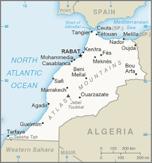
The Tarfaya Basin is a structural basin located in southern Morocco that extends westward into the Moroccan territorial waters in the Atlantic Ocean. The basin is named for the city of Tarfaya located near the border of Western Sahara, a region governed by the Kingdom of Morocco. The Canary Islands form the western edge of the basin and lie approximately 100 km to the west.
The geology of Somalia is built on more than 700 million year old igneous and metamorphic crystalline basement rock, which outcrops at some places in northern Somalia. These ancient units are covered in thick layers of sedimentary rock formed in the last 200 million years and influenced by the rifting apart of the Somali Plate and the Arabian Plate. The geology of Somaliland, the de facto independent country in northern Somalia, is to some degree better studied than that of Somalia as a whole. Instability related to the Somali Civil War and previous political upheaval has limited geologic research in places while heightening the importance of groundwater resources for vulnerable populations.
The geology of Bulgaria consists of two major structural features. The Rhodope Massif in southern Bulgaria is made up of Archean, Proterozoic and Cambrian rocks and is a sub-province of the Thracian-Anatolian polymetallic province. It has dropped down, faulted basins filled with Cenozoic sediments and volcanic rocks. The Moesian Platform to the north extends into Romania and has Paleozoic rocks covered by rocks from the Mesozoic, typically buried by thick Danube River valley Quaternary sediments. In places, the Moesian Platform has small oil and gas fields. Bulgaria is a country in southeastern Europe. It is bordered by Romania to the north, Serbia and North Macedonia to the west, Greece and Turkey to the south, and the Black Sea to the east.
The geology of Romania is structurally complex, with evidence of past crustal movements and the incorporation of different blocks or platforms to the edge of Europe, driving recent mountain building of the Carpathian Mountains. Romania is a country located at the crossroads of Central, Eastern, and Southeastern Europe. It borders the Black Sea to the southeast, Bulgaria to the south, Ukraine to the north, Hungary to the west, Serbia to the southwest, and Moldova to the east.
The geology of Greece is highly structurally complex due to its position at the junction between the European and African tectonic plates.

The Geology of Italy includes mountain ranges such as the Alps, the Dolomites and the Apennines formed from the uplift of igneous and primarily marine sedimentary rocks all formed since the Paleozoic. Some active volcanoes are located in Insular Italy.

The Alaskan North Slope (ANS) is a foreland basin located on the northern edge of the Brooks Range. The Alaskan North Slope is bounded on the north by the Beaufort Sea and runs from the Canadian border to the maritime boundary with Russia in the west. The western edge extends into the Chukchi Sea and Chukchi platform where the basin is at its widest. As the basin moves east it narrows towards the Canadian border. The basin is 1000 km long, 600 km at its widest, and covers a total area of 240,000 km2.

The Moltrasio Formation also known as Lombardische Kieselkalk Formation is a geological formation in Italy. This Formation mostly developed on the Lower ot Middle Sinemurian stage of the Lower Jurassic, where on the Lombardian basin tectonic activity modified the current marine and terrestrial habitats. Here it was developed a series of marine-related depositional settings, represented by an outcrop of 550–600 m of grey Calcarenites and Calcilutites with chert lenses and marly interbeds, that recovers the Sedrina, Moltrasio and Domaro Formations. This was mostly due to the post-Triassic crisis, that was linked locally to tectonics. The Moltrasio Formation is considered a continuation of the Sedrina Limestone and the Hettangian Albenza Formation, and was probably a shallow water succession, developed on the pasive margin of the westernmost Southern Alps. It is known due to the exquisite preservation observed on the Outcrop on Osteno, where several kinds of marine biota have been recovered.
References
- Bracco Gartner G., Morsilli M., Schlager W., Bosellini A. (2002). Toe-of-slope of a Cretaceous carbonate platform in outcrop, seismic model and offshore seismic data (Apulia, Italy). International Journal of Earth Science (Geologische Rundschau)91: 315–330. Berlin.
- Luciani V., Cobianchi M., Jenkyns H.C. (2004). Albian high-resolution biostratigraphy and isotope stratigraphy: The Coppa della Nuvola pelagic succession of the Gargano Promontory (Southern Italy). Eclogae geol. Helv.97: 77–92. Basel.
- Morsilli M., de Cosmo P.D., Luciani V., Bosellini A. (2003). Late Santonian partial drowning of the Apulia Carbonate Platform (Gargano Promontory, southern Italy): new data for paleogeographic reconstructions. 22nd I.A.S. Regional Meeting. Opatija, Croatia. Abstract Book, 135.
- Morsilli M., Rusciadelli G., Bosellini A. (2004). The Apulia carbonate platform-margin and slope, Late Jurassic to Eocene of the Maiella Mt. and Gargano Promontory: physical stratigraphy and architecture. Field Trip Guide Book - P18. 32nd International Geological Congress, Florence, Italy; 44 pp. A.P.A.T, Roma.