Arawa, Bougainville

Last updated
Arawa
Town
Arawa-Kieta.png
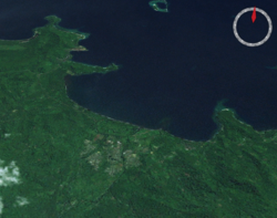
The city of Arawa, and the port of Kieta, from space
Location map Bourgainville Island.png
Red pog.svg
Arawa
Location within Bougainville Island
Coordinates: 6°13′30″S155°34′00″E / 6.22500°S 155.56667°E / -6.22500; 155.56667
Country Flag of Papua New Guinea.svg  Papua New Guinea
Province Autonomous Region of Bougainville
District Central Bougainville
LLG Arawa Rural LLG
Established1884
Population
 (2000)
  Total36,443
  Rank 3rd
Languages
   Main languages English, Tok Pisin
   Traditional language Naasioi
Time zone UTC+11 (BST)
Location22 km (14 mi) from Panguna
Mean max temp32 °C (90 °F)
Mean min temp23 °C (73 °F)
Annual rainfall3,037 mm (119.6 in)
Climate Af

Arawa is the largest town and the former capital of the Autonomous Region of Bougainville in Papua New Guinea. It is administered under Arawa Rural LLG. [1]

Contents

The town was largely destroyed during the Bougainville Civil War,[ citation needed ] resulting in the relocation of the capital to Buka, though there are plans to rebuild Arawa and make it the capital again. [2] The land where Arawa is now situated was previously a large expatriate plantation.

History

When Bougainville Copper Ltd needed a civic headquarters for dealing with the local and national government instrumentalities, Arawa Plantation was an obvious candidate. It was in close proximity to Kieta, the historic district headquarters whose geographical location made expansion difficult. It was also close to new commercial port facilities at Loloho in Anewa Bay north of Arawa, in addition to the small longstanding port near Kieta, which allowed rural agricultural products to be loaded onto cargo ships. The extremely busy Aropa Airport was south of Kieta, immediately adjacent to the sea.

The townsite was quickly developed through the 1970s and 1980s with residential neighbourhoods, commercial enterprises, large public schools in addition to long-established Roman Catholic schools in Kieta, a public library, hotels and restaurants and entertainment facilities such as a film theatre.

Villagers throughout Bougainville Island and Buka Island had long been accustomed to seeing films at church stations, while residents from elsewhere greatly desired them; videos were common and frequently shown by Lutheran, Anglican and Baptist churches in the area in an attempt to attract converts. These denominations did not previously operate on Bougainville and Buka, which prior to the Panguna mine had largely been Roman Catholic and Methodist United Church in Papua New Guinea and the Solomon Islands.

See also

Related Research Articles

<span class="mw-page-title-main">Autonomous Region of Bougainville</span> Autonomous region of Papua New Guinea

Bougainville, officially the Autonomous Region of Bougainville, is an autonomous region in Papua New Guinea. The largest island is Bougainville Island, while the region also includes Buka Island and a number of outlying islands and atolls. The current capital is Buka, situated on Buka Island.

<span class="mw-page-title-main">Bougainville Island</span> Island in Papua New Guinea

Bougainville Island is the main island of the Autonomous Region of Bougainville, which is part of Papua New Guinea. It was previously the main landmass in the German Empire-associated North Solomons. Its land area is 9,300 km2 (3,600 sq mi). The population of the whole province, including nearby islets such as the Carterets, is approximately 300,000. The highest point is Mount Balbi, on the main island, at 2,715 m (8,907 ft). The much smaller Buka Island, c. 500 km2 (190 sq mi), lies to the north, across the 400–500 m (1,300–1,600 ft) wide Buka Strait. Even though the strait is narrow, there is no bridge across it, but there is a regular ferry service between the key settlements on either side. The main airport in the north is in the town of Buka.

<span class="mw-page-title-main">History of Bougainville</span> Bougainville, region in Papua New Guinea

Bougainville, an autonomous region of Papua New Guinea (PNG), has been inhabited by humans for at least 29,000 years, according to artefacts found in Kilu Cave on Buka Island. The region is named after Bougainville Island, the largest island of the Solomon Islands archipelago, but also contains a number of smaller islands.

Buka can refer to:

<span class="mw-page-title-main">Kieta</span> Place in Bougainville, Papua New Guinea

Kieta is a port town located on the eastern coast of the island of Bougainville in Papua New Guinea, near the township of Arawa. After extensive destruction during the 1990 Civil Uprising on Bougainville, Kieta has few inhabitants now, and is known mainly for its transport connections.

<span class="mw-page-title-main">Buka Island</span> Island of Papua New Guinea

Buka Island is the second-largest island in the Autonomous Region of Bougainville, in eastern Papua New Guinea. It is in Buka Rural LLG of North Bougainville District, with the Autonomous Region's and district's capital city of Buka on the island.

Joseph Canisius Kabui was a secessionist leader and the first President of the Autonomous Region of Bougainville, off the coast of Papua New Guinea, from 2005 to 2008. He was also the leader of the Bougainville People's Congress.

<span class="mw-page-title-main">UTC+11:00</span> Identifier for a time offset from UTC of +11

UTC+11:00 is an identifier for a time offset from UTC of +11:00. This time is used in:

<span class="mw-page-title-main">North Solomon Islands</span> Island group in Western Pacific

<span class="mw-page-title-main">Nissan Island</span>

Nissan Island is the largest of the Green Islands of Papua New Guinea. It is located at 4°30′S154°13′E, about 200 km east of Rabaul on New Britain and about 200 km north-west of Bougainville. The island is administered under Nissan Rural LLG in the Autonomous Region of Bougainville. Nissan island, along with other nearby islands, has been described as a "stepping stone island" and it is believed that this island plays an important role in helping various plant and animal species spread throughout the region.

<span class="mw-page-title-main">Buka, Bougainville</span> Town in Autonomous Region of Bougainville, Papua New Guinea

Buka is a town located on the southern coast of Buka Island, in the Autonomous Region of Bougainville, in eastern Papua New Guinea. It is administered under Buka Rural LLG. It is the capital of the North Bougainville District and the interim capital of the Autonomous Region of Bougainville. It contains Our Lady of the Assumption Cathedral.

<span class="mw-page-title-main">Districts of Papua New Guinea</span> Second-level administrative division

This page is a list of districts of Papua New Guinea.

<span class="mw-page-title-main">Buin, Papua New Guinea</span> Town in Autonomous Region of Bougainville, Papua New Guinea

Buin is a town on Bougainville Island, and the capital of the South Bougainville District, in the Autonomous Region of Bougainville, in eastern Papua New Guinea. The island is in the northern Solomon Islands Archipelago of the Melanesia region, in the South Pacific Ocean.

Central Bougainville District is a district of the Autonomous Region of Bougainville of Papua New Guinea. Its capital is Arawa-Kieta.

Selau is a district of the Autonomous Region of Bougainville, Papua New Guinea. Generally it is known as Selau-Suir Rural LLG which is one of the districts in Bougainville.

The Our Lady of the Assumption Cathedral is a religious building belonging to the Roman Catholic Church and is located in the town of Buka on the south coast of the island of Buka, in the autonomous region of Bougainville, formerly ″province of Bougainville″ which is part of Papua New Guinea a country in Oceania.

Buka Rural LLG is a local-level government (LLG) of comprising Buka Island in the Autonomous Region of Bougainville, Papua New Guinea. Several Northwest Solomonic languages are spoken in the LLG.

Arawa Rural LLG is a local-level government (LLG) of the Autonomous Region of Bougainville, Papua New Guinea.

<span class="mw-page-title-main">COVID-19 pandemic in the Autonomous Region of Bougainville</span> Ongoing COVID-19 viral pandemic in the Autonomous Region of Bougainville

The COVID-19 pandemic in the Autonomous Region of Bougainville is part of the ongoing worldwide pandemic of coronavirus disease 2019 caused by severe acute respiratory syndrome coronavirus 2. The Autonomous Region of Bougainville's confirmed its first case of the COVID-19 pandemic on Friday, August 7, 2020, in Arawa, Bougainville. The first documented arrival of COVID-19 in Bougainville occurred just before the start of the Bougainvillean general and presidential elections, which took place over the course of three weeks beginning on August 12, 2020, and ending on September 1, 2020.

<span class="mw-page-title-main">Francis Hagai</span> Former leader of Hahalis Welfare Society

Francis Hagai was the leader of the Hahalis Welfare Society (HWS) on Buka Island, in what is now the Autonomous Region of Bougainville in Papua New Guinea. He received a Catholic education but later sought to establish an alternative church and revive traditional customs. In 1962 he led the HWS in a conflict with Australian authorities over a tax dispute and was briefly jailed. Although he was unsuccessful in bids for public office, he has been credited with drawing greater attention to Buka.

References

  1. United Nations in Papua New Guinea (2018). "Papua New Guinea Village Coordinates Lookup". Humanitarian Data Exchange. 1.31.9.
  2. The Report: Papua New Guinea 2016. Oxford Business Group. September 19, 2016. ISBN   9781910068649 . Retrieved September 1, 2020 via Google Books.