Mount Brazeau is a mountain in Alberta, Canada.

The Blue Range is a mountain range of the Canadian Rockies, located on the Continental Divide in Banff National Park, Canada. The range was so named on account of its blueish colour when viewed from afar. Mount Alcantara is the highest point in the range.

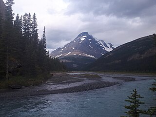
Pyramid Mountain is a mountain in Jasper National Park, Alberta, Canada, named for its pyramid-like shape. James Hector named the mountain in 1859 due to its appearance from the Athabasca River valley on the eastern side of the peak.
The Fiddle Range is a mountain range of the Canadian Rockies located south of Highway 16 on the east border of Jasper National Park, Canada.
Mount Farnham is British Columbia's 17th highest peak, and 21st most prominent. It was named after Paulding Farnham from New York. It is the highest peak in the Purcells.
Mount Bess is located on the border of Alberta and British Columbia. It is the 83rd highest peak in Alberta. It was named in 1910 by J. Norman Collie after Bessie Gunn, who accompanied Collie's expedition.
Dungeon Peak is a 3,129-metre (10,266 ft) mountain summit located on the shared border of Jasper National Park in Alberta, and Mount Robson Provincial Park in British Columbia, Canada. Dungeon Peak is part of The Ramparts in the Tonquin Valley. The descriptive name was applied in 1916 by Morrison P. Bridgland (1878-1948), a Dominion Land Surveyor who named many peaks in Jasper Park and the Canadian Rockies. The mountain's name was made official in 1935 by the Geographical Names Board of Canada.

Mount Fraser is a mountain located on the border of Alberta and British Columbia. It is Alberta's 38th highest peak and Alberta's 22nd most prominent mountain. It is also British Columbia's 50th highest peak. It was named in 1917 after Simon Fraser.
Mount Ross Cox is located north of the Hooker Icefield in Hamber Provincial Park and straddles the Continental Divide marking the Alberta-British Columbia border. It was named in 1920 after Ross Cox who traveled the area in 1817.
Mount Scott is located on the border of Alberta and British Columbia, North of the Hooker Icefield in Hamber Provincial Park. It is Alberta's 44th highest peak, and Alberta's 46th most prominence mountain. It is also British Columbia's 57th highest peak. It was named in 1913 after Captain Robert Falcon Scott.
Mount Hooker is located on the border of Alberta and British Columbia, Canada. It was named in 1827 by David Douglas after William Jackson Hooker. Until the turn of the century, Mount Hooker and the nearby Mount Brown were thought to be the highest mountains in the Canadian Rockies.
Chaba Peak is located in the Chaba Icefield south of Fortress Lake in Hamber Provincial Park on the Continental Divide marking the Alberta-British Columbia border. It was named in 1920 after the Chaba River by the Interprovincial Boundary Survey. Chaba is the Stoney Indian word for beaver.
Fresnoy Mountain is located on the border of Alberta and British Columbia. It was named in 1919 after Fresnoy-en-Gohelle, a village in France, in commemoration of the World War I battle fought there by Canadian forces in 1917.
Douai Mountain is a mountain on the border of Alberta and British Columbia, named in 1918 after Douai, a village in France liberated by Canadians and allies in World War I.

Ernest Peak - a.k.a. Lyell 3, L3 or Mt. Lyell - is the central and highest peak of five distinct subpeaks on Mount Lyell (Canada) and is located on the border of Alberta and British Columbia.. It was named in 1972 by Sydney R. Vallance after Ernest Feuz Jr.

Christian Peak - a.k.a. Lyell 5 or L5 - is the least tall of five distinct subpeaks on Mount Lyell (Canada) and is located on the border of Alberta and British Columbia. It was named in 1972 by Sydney R. Vallance after Christian Hässler, Jr.
Chimney Peak is located at the northeastern end of Kootenay National Park just south of Quadra Mountain and straddles the Continental Divide marking the Alberta-British Columbia border. It was named in 1910 by T.G. Longstaff and Captain E.O. Wheeler who made its first ascent through a chimney.

Fatigue Mountain is located on the border of Alberta and British Columbia on the Continental DivideThe mountain was named in 1888 by W.S. Drewry who became fatigued on the first ascent.

Brussels Peak is a 3,161-metre (10,371 ft) mountain summit located in the Athabasca River valley of Jasper National Park, in the Canadian Rockies of Alberta, Canada. The nearest higher peak is Mount Fryatt, 6.75 km (4.19 mi) to the northwest. Brussels Peak can be seen from the Icefields Parkway.

Marmot Mountain is a 2,608-metre (8,556-foot) mountain summit located in Alberta, Canada.