
Icicle Creek is a non navigable stream in the U.S. state of Washington. It originates at Josephine Lake near the crest of the Cascade Range and flows generally east to join the Wenatchee River near Leavenworth. Icicle Creek's drainage basin is mountainous and mostly undeveloped land within the Wenatchee National Forest and the Alpine Lakes Wilderness. The final 6 miles (10 km) of the creek are moderately developed with scattered homes and pasture, a golf course, children's camp, a small housing development called Icicle Island Club, and the Leavenworth National Fish Hatchery. Some water is diverted from the creek for municipal use by the City of Leavenworth at Icicle Creek river mile 5.6. Near Leavenworth, the wheelchair-accessible Icicle Creek Nature Trail, a National Recreation Trail designated in 2005, runs 1.0 mile (1.6 km) along a historic creek channel.

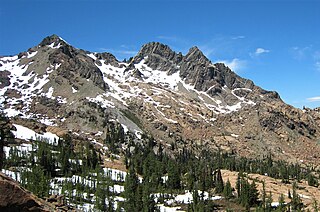
Colchuck Peak is an 8,705-foot (2,653-metre) mountain summit located in the Stuart Range, in the Alpine Lakes Wilderness in Chelan County of Washington state. The nearest higher peak is Dragontail Peak, 0.49 mi (0.79 km) to the east, and Argonaut Peak lies 0.9 mi (1.4 km) to the southwest. The Colchuck Glacier which lies on the northeast slopes of the peak melts into Colchuck Lake. The mountain and glacier take their name from the lake, which in Chinook jargon means "cold water". Precipitation runoff from the peak drains north into Mountaineer Creek, a tributary of Icicle Creek, or south into Ingalls Creek, all of which winds up in the Wenatchee River. Colchuck Peak is more notable for its steep rise above local terrain than for its absolute elevation as topographic relief is significant with the summit rising 3,130 feet (954 m) above Colchuck Lake in 1 mi (1.6 km), and 4,600 feet (1,402 m) above Ingalls Creek in 1.9 mi (3.1 km).
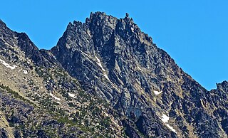
Sherpa Peak is an 8,630-foot (2,630-metre) granite summit located in the Stuart Range, in the Alpine Lakes Wilderness in Chelan County of Washington state. The nearest higher peak is Mount Stuart, 0.41 mi (0.66 km) to the west, and Argonaut Peak lies 1.29 mi (2.08 km) to the east. The Sherpa Glacier lies on the northern slope of the peak. Precipitation runoff from the peak drains north into Mountaineer Creek, a tributary of Icicle Creek, or south into Ingalls Creek, all of which winds up in the Wenatchee River. According to the USGS, this peak is named for a local climbing club that was active in the area in the 1950s, and the toponym was officially adopted in 1988 by the U.S. Board on Geographic Names.

Castle Peak is a prominent 8,343-foot (2,543-metre) mountain summit located in the Hozameen Range of the North Cascades, on the shared border between Okanogan County and Whatcom County of Washington state. The mountain is situated one mile (1.6 km) south of the Canada–United States border, on the Cascade crest, in the Pasayten Wilderness, on land managed by the Okanogan–Wenatchee National Forest. The nearest higher peak is Jack Mountain, 14.8 miles (23.8 km) to the south-southwest. Castle Peak is the second highest summit of the Hozameen Range following Jack Mountain. Castle Peak is the sixth-highest mountain in the Pasayten Wilderness. Precipitation runoff from the mountain drains east into Castle Creek, a tributary of the Similkameen River, or west into tributaries of the Skagit River. Topographic relief is significant as the summit rises nearly 3,000 feet above Crow Creek in 0.75 mile (1.2 km).

Alaska Mountain is a 5,745-foot (1,751-metre) mountain summit located in the Cascade Range, in Kittitas County of Washington state. It is situated within the Alpine Lakes Wilderness on land managed by Wenatchee National Forest. Alaska Mountain is set between Alaska Lake and Joe Lake, 8 miles (13 km) northeast of Snoqualmie Pass, and 0.81 miles (1.30 km) southeast of Mount Thomson, which is also its nearest higher peak. The Pacific Crest Trail traverses around the south, east and north slopes of Alaska Mountain, and an off-trail hike leads to the summit. Precipitation runoff on the east side of the mountain drains into tributaries of the Yakima River, whereas the west side of the peak drains into tributaries of the Snoqualmie River.

Four Brothers is a 6,485-foot-elevation (1,977-meter) mountain summit located in Kittitas County of Washington state.
Ingalls Peak is a 7,662-foot (2,335-metre) triple-summit mountain located in the Alpine Lakes Wilderness, along the common border of Kittitas County and Chelan County, in Washington state. Ingalls Peak is the highest point in the Teanaway area of the Wenatchee Mountains. It is situated 2 mi (3.2 km) west of Mount Stuart, and immediately west of Lake Ingalls, on land managed by Wenatchee National Forest. Its subpeaks are the South Peak and the East Peak. Precipitation runoff from the peak drains north into Jack Creek, a tributary of Icicle Creek; west into Fortune Creek; or east into Ingalls Creek, a tributary of the Wenatchee River. This peak, the lake, creek, and pass are named for Captain Benjamin Ingalls of the United States Cavalry who led an 1855 survey of this area and is credited with discovering gold in the region.

Jim Hill Mountain is a prominent 6,765 ft (2,060 m) mountain summit located in Chelan County of Washington state. Jim Hill Mountain is situated 3.5 mi (5.6 km) east of Stevens Pass, on the boundary of Alpine Lakes Wilderness, on land managed by the Okanogan–Wenatchee National Forest. Jim Hill Mountain is part of the Chiwaukum Mountains, which are a subset of the Cascade Range. Its nearest higher neighbor is Bulls Tooth, 3.8 mi (6.1 km) to the south. Precipitation runoff from the peak drains into tributaries of Nason Creek, which in turn is a tributary of the Wenatchee River. Jim Hill Mountain is set immediately south of the east portal of the Cascade Tunnel, which was built by the Great Northern Railway. This mountain was named by Albert Hale Sylvester to honor James J. Hill (1838–1916), the chief executive officer of the Great Northern Railway. Hill became known during his lifetime as "The Empire Builder", a name bestowed to the Empire Builder passenger train that runs from Seattle to Chicago, and traverses below this mountain.

Eightmile Mountain is a 7,996-foot (2,437-metre) mountain summit located in Chelan County of Washington state. Eightmile Mountain is situated within the Alpine Lakes Wilderness, on land managed by the Okanogan–Wenatchee National Forest. It is part of the Wenatchee Mountains which are a subset of the Cascade Range. Its nearest higher neighbor is Cashmere Mountain, 3 mi (4.8 km) to the northeast, and Mount Stuart rises 4 mi (6.4 km) to the south. Precipitation runoff from the mountain drains into Trout Creek and Eightmile Creek, both tributaries of Icicle Creek, which in turn is a tributary of the Wenatchee River. This mountain is known for its spring skiing and excellent view of the Stuart Range.

Granite Mountain is a 7,144-foot (2,177-metre) double summit mountain located 11.5 mi (18.5 km) south of Stevens Pass on the common border of Kittitas County and Chelan County in Washington state. It's part of the Wenatchee Mountains, which are a subset of the Cascade Range, and is situated 19 mi (31 km) west of Leavenworth in the Alpine Lakes Wilderness, on land managed by the Okanogan–Wenatchee National Forest. Granite Mountain is the highest point on the Hyas Lake-French Creek divide with precipitation runoff from the mountain draining west into Cle Elum River, or east into French Creek, a tributary of Icicle Creek. Its subsidiary 7,080-ft South Peak is positioned half a mile to the south-southeast, the nearest higher neighbor is The Cradle, 3 mi (4.8 km) to the southeast, and Mac Peak is set 3.6 mi (5.8 km) to the north-northwest. The Pacific Crest Trail skirts below the western base this peak.

Navaho Peak is a 7,223-foot (2,202-metre) mountain summit located on the boundary of the Alpine Lakes Wilderness, on the shared border of Kittitas County with Chelan County in Washington state. Navaho Peak is the fourth-highest point in the Teanaway area of the Wenatchee Mountains. It is situated two miles northeast of Earl Peak, and 1.3 miles west of Three Brothers, on land managed by Wenatchee National Forest. Precipitation runoff from the peak drains south into tributaries of the Teanaway River, or north into tributaries of Ingalls Creek which is part of the Wenatchee River drainage basin. The view from the summit of this peak showcases the impressive Mount Stuart and Stuart Range for those who climb it.

Bills Peak is a 6,917-foot (2,108-metre) mountain summit located on the common border of Kittitas County with Chelan County in Washington state. It is the tenth-highest point in the Teanaway area of the Wenatchee Mountains. Bills Peak is situated 2.6 mi (4.2 km) west-northwest of Earl Peak, its nearest higher neighbor, on the boundary of the Alpine Lakes Wilderness, on land managed by Wenatchee National Forest. Precipitation runoff from the peak drains south into tributaries of the Teanaway River, or north into tributaries of Ingalls Creek which is part of the Wenatchee River drainage basin. The view from the summit of this peak showcases the impressive Mount Stuart and Stuart Range. Bills Peak was named after William Noble "Bill" Prater (1926–2010), a mountaineer and farmer from nearby Ellensburg.

Harding Mountain is a 7,173 ft (2,190 m) mountain summit located in Chelan County of Washington state. It is the seventh-highest point in the North Wenatchee Mountains. Harding Mountain is situated within the Alpine Lakes Wilderness, 5.35 mi (8.61 km) northwest of Mount Stuart, and 4.1 mi (6.6 km) west of Eightmile Mountain, on land managed by Wenatchee National Forest. Precipitation runoff from the peak drains into tributaries of Icicle Creek, which in turn is a tributary of the Wenatchee River. This mountain was named after President Warren G. Harding by Albert Hale Sylvester.

Three Queens is a prominent 6,693-foot (2,040-metre) triple-summit mountain located in the Cascade Range, in Kittitas County of Washington state. It is set within the Alpine Lakes Wilderness on land managed by Wenatchee National Forest. The East Peak is the highest, and its subpeaks are the Middle Peak, and West Peak. Three Queens is set 6.5 miles (10.5 km) east-northeast of Snoqualmie Pass, on Chikamin Ridge, 2.76 miles (4.44 km) southeast of its nearest higher neighbor, Chikamin Peak. The Pacific Crest Trail traverses the west slope of Three Queens as it crosses the gap between Four Brothers and Three Queens. Precipitation runoff from the mountain drains into tributaries of the Yakima River drainage basin. The first ascent was likely made in 1925 by a party of eight Mountaineers led by Glen Bremerman and C. A. Fisher. This mountain's toponym was officially adopted in 1940 by the United States Board on Geographic Names.

Cape Horn is a 7,316-foot (2,230-metre) mountain summit located in Chelan County of Washington state. Cape Horn is situated 12 mi (19 km) west-northwest of Leavenworth, within the Alpine Lakes Wilderness, on land managed by the Okanogan–Wenatchee National Forest. Cape Horn is part of the Chiwaukum Mountains, a subset of the Cascade Range. The nearest higher neighbor is Ladies Peak, 0.9 mi (1.4 km) to the northwest, and Grindstone Mountain is set 1.4 mi (2.3 km) to the south. Precipitation runoff from Cape Horn drains west to Icicle Creek, whereas the east slopes drain into Chiwaukum Creek, and both are tributaries of the Wenatchee River. Although modest in elevation, relief is significant since this peak rises over 4,300 feet above Icicle Creek Valley in approximately two miles, and 2,100 feet above the Spanish Camp Creek in one mile. This mountain was named by Albert Hale Sylvester in 1909 for its sharp profile. This mountain's toponym has been officially by the United States Board on Geographic Names.
Ladies Peak is a 7,708-foot (2,349-metre) mountain summit located in Chelan County of Washington state. Ladies Peak is situated 13 mi (21 km) west-northwest of Leavenworth, within the Alpine Lakes Wilderness, on land managed by the Okanogan–Wenatchee National Forest. Ladies Peak is part of the Chiwaukum Mountains, a subset of the Cascade Range. Its nearest higher neighbor is Snowgrass Mountain, 1.27 mi (2.04 km) to the north, and Cape Horn is set 0.9 mi (1.4 km) to the southeast. Precipitation runoff from Ladies Peak drains west to Icicle Creek, whereas the east slopes drain into Chiwaukum Creek, and both are tributaries of the Wenatchee River. Although modest in elevation, relief is significant since this peak rises over 4,700 feet above Icicle Creek Valley in approximately two miles. This unofficially named peak is named in association with the nearby officially named Ladies Pass, which like many geographical features in this region was named by Albert Hale Sylvester.

Big Lou is a 7,780+ ft mountain summit located in Chelan County of Washington state. It is situated 8.5 mi (13.7 km) west-northwest of Leavenworth, on the boundary of the Alpine Lakes Wilderness, and on land managed by the Okanogan–Wenatchee National Forest. Big Lou is the highest point on Icicle Ridge, and is the third-highest peak in the Chiwaukum Mountains, a subset of the Cascade Range. Its nearest higher neighbor is Snowgrass Mountain, 5 mi (8.0 km) to the northwest, and slightly lower Big Jim Mountain is set 1.75 mi (2.82 km) to the north-northeast. Precipitation runoff from Big Lou drains into Icicle Creek and other tributaries of the Wenatchee River. Although modest in elevation, relief is significant since Big Lou rises 5,200 feet above Icicle Creek Valley in approximately two miles. Big Lou is named for mountaineer Lou Whittaker, the twin brother of Jim Whittaker, the first American to summit Mount Everest.

Three Brothers is a 7,303-foot-elevation triple-peak mountain summit located in Chelan County of Washington state. It is situated 1.3 miles east of Navaho Peak, on the boundary of the Alpine Lakes Wilderness, on land managed by Wenatchee National Forest. Three Brothers is the third-highest point in the Teanaway area of the Wenatchee Mountains. Precipitation runoff from the peak drains into tributaries of the Wenatchee River. The view from the summit of this peak showcases the impressive Mount Stuart and Stuart Range for those who climb it.

Tinkham Peak is a double summit mountain located on the common boundary of King County and Kittitas County in Washington state.

Wedge Mountain is a 5,860-foot-elevation (1,786-meter) summit located in Chelan County of Washington state. It is set on the boundary line of the Alpine Lakes Wilderness, on land managed by Okanogan-Wenatchee National Forest. Wedge Mountain is the northeastern terminus of the Stuart Range, which is a subset of the Cascade Range. It is situated 3.5 miles (5.6 km) northeast of The Temple, and the nearest town is Leavenworth, 5 miles (8.0 km) to the north-northeast. Precipitation runoff from the mountain drains into tributaries of the Wenatchee River. Topographic relief is significant as the summit rises over 2,800 feet above Snow Creek in one-half mile. Backpackers hiking en route to The Enchantments via the Snow Creek Trail traverse the western foot of this mountain. Wedge Mountain is the toponym officially adopted by the U.S. Board on Geographic Names for the 5,860-foot summit.


