
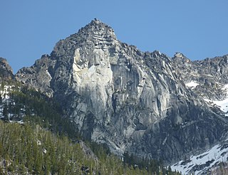
Dragontail Peak, also known as Dragon Tail, is a mountain in the Stuart Range, in Chelan County, Washington. While climbing an adjacent peak, Lex Maxwell, Bob McCall, and Bill Prater remarked that the needles on the crest, southwest of the summit, resembled a "dragon tail". The name was officially accepted in 1955. On the mountain's northeast flank lies Colchuck Lake which drains into Mountaineer Creek, and Colchuck Glacier lies below the western slopes of the peak. On its south side the mountain drops steeply to Ingalls Creek, which flows about 5,800 feet (1,800 m) below the summit.
Prusik Peak is an 8000+ ft granite summit located at the west end of The Temple in Chelan County of Washington state. Prusik Peak is part of The Enchantments within the Alpine Lakes Wilderness, and is often the iconic photographic image of both areas. Prusik Peak belongs to the Stuart Range which is a subset of the Cascade Range. The name honors Dr. Karl Prusik (1896–1961) who was an Austrian mountaineer, and is known as the inventor of the prusik, a rope knot which happened to be used to gain access to the summit horn during the first ascent by Fred Beckey in 1948. Precipitation runoff drains into Icicle Creek, a tributary of the Wenatchee River.

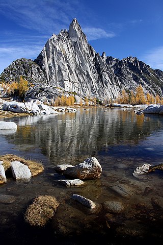
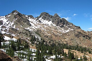
Enchantment Peak is an 8,520+ ft granite summit located in Chelan County of Washington state. Enchantment Peak is part of The Enchantments within the Alpine Lakes Wilderness. Enchantment Peak belongs to the Stuart Range which is subset of the Cascade Range. Enchantment Peak is situated midway between Prusik Peak to its east, and Aasgard Pass and Dragontail Peak to the west. Precipitation runoff drains into Icicle Creek, a tributary of the Wenatchee River.
Little Annapurna is an 8,440+ ft granite summit located in Chelan County of Washington state. The origin of the name came from the Sherpa Climbing Club of Ellensburg, and is inspired by the obvious resemblance to its Himalayan namesake when comparing the south faces of both. Little Annapurna is part of The Enchantments within the Alpine Lakes Wilderness, and is set on land managed by the Okanogan–Wenatchee National Forest. It belongs to the Stuart Range which is subset of the Cascade Range. Little Annapurna is situated southeast of Dragontail Peak, which is its nearest higher neighbor. Remnants of the receding Snow Creek Glacier can be found on its gentle north slope. Precipitation runoff drains into tributaries of the Wenatchee River.

Jabberwocky Tower is a 6,840-foot-elevation granite spire located in Chelan County of Washington state. Jabberwocky Tower is part of The Enchantments within the Alpine Lakes Wilderness. It belongs to the Stuart Range which is subset of the Cascade Range. Jabberwocky Tower is situated east of Colchuck Lake and west of Enchantment Peak. Precipitation runoff drains into Icicle Creek, a tributary of the Wenatchee River.
Cannon Mountain is an 8,638 ft mountain summit located in Chelan County of Washington state. Cannon Mountain is part of The Enchantments, within the Alpine Lakes Wilderness. Cannon Mountain belongs to the Stuart Range which is subset of the Cascade Range. Cannon Mountain is situated one mile north of Enchantment Peak. The nearest higher peak is Dragontail Peak, 2.15 mi (3.46 km) to the southwest. Precipitation runoff drains into Icicle Creek, a tributary of the Wenatchee River.

Hibox Mountain is a 6,547-foot (1,996-metre) mountain summit located in the Cascade Range in Kittitas County of Washington state. It is situated within the Alpine Lakes Wilderness on land managed by Okanogan-Wenatchee National Forest. The mountain's name "Hibox" is a portmanteau which is derived from its position as the high point of Box Ridge. The peak is five miles east of Snoqualmie Pass, and Alta Mountain lies 1.5 miles to the west-northwest of Hibox. Precipitation runoff from the mountain drains into Box Canyon Creek and Mineral Creek which both empty to Kachess Lake.

Big Chiwaukum is a prominent 8,081-foot (2,463-metre) mountain summit located in Chelan County of Washington state. Big Chiwaukum is situated northeast of Frosty Pass, and within the Alpine Lakes Wilderness. Big Chiwaukum is the highest peak in the Chiwaukum Mountains, a subset of the Cascade Range. In the Wenatchee dialect, Chiwaukum means many little creeks running into one big one. Its nearest higher peak is Cashmere Mountain, 10.35 mi (16.66 km) to the south-southeast. Precipitation runoff from Big Chiwaukum drains into tributaries of the Wenatchee River.

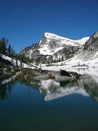
Colchuck Peak is an 8,705-foot (2,653-metre) mountain summit located in the Stuart Range, in the Alpine Lakes Wilderness in Chelan County of Washington state. The nearest higher peak is Dragontail Peak, 0.49 mi (0.79 km) to the east, and Argonaut Peak lies 0.9 mi (1.4 km) to the southwest. The Colchuck Glacier which lies on the northeast slopes of the peak melts into Colchuck Lake. The mountain and glacier take their name from the lake, which in Chinook jargon means "cold water". Precipitation runoff from the peak drains north into Mountaineer Creek, a tributary of Icicle Creek, or south into Ingalls Creek, all of which winds up in the Wenatchee River. Colchuck Peak is more notable for its steep rise above local terrain than for its absolute elevation as topographic relief is significant with the summit rising 3,130 feet (954 m) above Colchuck Lake in 1 mi (1.6 km), and 4,600 feet (1,402 m) above Ingalls Creek in 1.9 mi (3.1 km).
Colchuck Balanced Rock is an 8,200+ ft granite mountain summit located in Chelan County of Washington state. Colchuck Balanced Rock is part of The Enchantments within the Alpine Lakes Wilderness. It belongs to the Stuart Range which is subset of the Cascade Range. Colchuck Balanced Rock is situated west of Enchantment Peak, and east of Jabberwocky Tower and Colchuck Lake. Precipitation runoff from the peak drains into the lake and Mountaineer Creek, a tributary of Icicle Creek. The climbing approach is via the Colchuck Lake Trail, then traversing away from Aasgard Pass approximately 400 feet above the lake. The mountain is named for its pyramidal summit which has a top-block that nests, rather than balances, on the summit. The mountain and glacier take their name from the lake, which in Chinook jargon means "cold water".

The Temple is an 8,292-foot (2,527-metre) granite mountain summit located in Chelan County of Washington state. The Temple is part of The Enchantments, set within the Alpine Lakes Wilderness. The Temple belongs to the Stuart Range which is a subset of the Cascade Range. The nearest higher peak is Enchantment Peak, 1.55 miles (2.49 km) to the west, and the nearest town is Leavenworth, 8 miles (13 km) to the northeast. The mountain hosts many granite spires with names like The High Priest, The Boxtop, Flake Tower, Comet Spire, Razorback Spire, The Meteor, The Professor, Lighthouse Tower, Black Pyramid, and the most recognizable Prusik Peak. The highest point of the mountain is called Mt. Temple. Precipitation runoff from the mountain drains into Snow Creek which is a tributary of Icicle Creek.
Ingalls Peak is a 7,662-foot (2,335-metre) triple-summit mountain located in the Alpine Lakes Wilderness, along the common border of Kittitas County and Chelan County, in Washington state. Ingalls Peak is the highest point in the Teanaway area of the Wenatchee Mountains. It is situated 2 mi (3.2 km) west of Mount Stuart, and immediately west of Lake Ingalls, on land managed by Wenatchee National Forest. Its subpeaks are the South Peak and the East Peak. Precipitation runoff from the peak drains north into Jack Creek, a tributary of Icicle Creek; west into Fortune Creek; or east into Ingalls Creek, a tributary of the Wenatchee River. This peak, the lake, creek, and pass are named for Captain Benjamin Ingalls of the United States Cavalry who led an 1855 survey of this area and is credited with discovering gold in the region.

Eightmile Mountain is a 7,996-foot (2,437-metre) mountain summit located in Chelan County of Washington state. Eightmile Mountain is situated within the Alpine Lakes Wilderness, on land managed by the Okanogan–Wenatchee National Forest. It is part of the Wenatchee Mountains which are a subset of the Cascade Range. Its nearest higher neighbor is Cashmere Mountain, 3 mi (4.8 km) to the northeast, and Mount Stuart rises 4 mi (6.4 km) to the south. Precipitation runoff from the mountain drains into Trout Creek and Eightmile Creek, both tributaries of Icicle Creek, which in turn is a tributary of the Wenatchee River. This mountain is known for its spring skiing and excellent view of the Stuart Range.

Grindstone Mountain is a 7,533-foot (2,296-metre) mountain summit located in the Icicle Creek Valley in Chelan County of Washington state. Grindstone Mountain is situated 12 mi (19 km) west of Leavenworth, within the Alpine Lakes Wilderness, on land managed by the Okanogan–Wenatchee National Forest. Grindstone Mountain is the seventh-highest peak in the Chiwaukum Mountains, a subset of the Cascade Range. Its nearest higher neighbor is Ladies Peak, 2.2 mi (3.5 km) to the north-northwest, and Cape Horn is set 1.4 mi (2.3 km) to the north. Precipitation runoff from Grindstone drains into Icicle Creek, which is a tributary of the Wenatchee River. Although modest in elevation, relief is significant since Grindstone rises 4,700 feet above Icicle Creek Valley in less than two miles. Grindstone Mountain was named by Albert Hale Sylvester in association with Grindstone Creek, which flows from Sylvester Lake on this mountain's southwest slope. Sylvester found a small grindstone which had fallen from a pack horse fording the creek.

Bills Peak is a 6,917-foot (2,108-metre) mountain summit located on the common border of Kittitas County with Chelan County in Washington state. It is the tenth-highest point in the Teanaway area of the Wenatchee Mountains. Bills Peak is situated 2.6 mi (4.2 km) west-northwest of Earl Peak, its nearest higher neighbor, on the boundary of the Alpine Lakes Wilderness, on land managed by Wenatchee National Forest. Precipitation runoff from the peak drains south into tributaries of the Teanaway River, or north into tributaries of Ingalls Creek which is part of the Wenatchee River drainage basin. The view from the summit of this peak showcases the impressive Mount Stuart and Stuart Range. Bills Peak was named after William Noble "Bill" Prater (1926–2010), a mountaineer and farmer from nearby Ellensburg.

Teanaway Peak is a 6,779-foot (2,066-metre) mountain summit located in the Wenatchee Mountains, on the shared border of Kittitas County with Chelan County in Washington state. It is situated on the boundary of the Alpine Lakes Wilderness, on land managed by Wenatchee National Forest. Its nearest higher neighbor is Bills Peak, 0.72 mi (1.16 km) to the east. Precipitation runoff from the peak drains south into tributaries of the Teanaway River, or north into Turnpike Creek which is part of the Wenatchee River drainage basin. The view from the summit of this peak showcases the impressive Mount Stuart and Stuart Range for those who climb it. This peak also goes by the name "Genes Peak", which is for Gene Prater (1929–1993), the younger brother of Bill Prater, for whom Bills Peak was named. Gene was co-inventor of the modern aluminum snowshoe, and author of the seminal book, "Snowshoeing: From Novice to Master." Gene is also credited with first ascents of Sherpa Peak, Colchuck Balanced Rock, and the east summit of Ingalls Peak.

Cape Horn is a 7,316-foot (2,230-metre) mountain summit located in Chelan County of Washington state. Cape Horn is situated 12 mi (19 km) west-northwest of Leavenworth, within the Alpine Lakes Wilderness, on land managed by the Okanogan–Wenatchee National Forest. Cape Horn is part of the Chiwaukum Mountains, a subset of the Cascade Range. Its nearest higher neighbor is Ladies Peak, 0.9 mi (1.4 km) to the northwest, and Grindstone Mountain is set 1.4 mi (2.3 km) to the south. Precipitation runoff from Cape Horn drains west to Icicle Creek, whereas the east slopes drain into Chiwaukum Creek, and both are tributaries of the Wenatchee River. Although modest in elevation, relief is significant since this peak rises over 4,300 feet above Icicle Creek Valley in approximately two miles. This mountain was named by Albert Hale Sylvester in 1909 for its sharp profile.

Witches Tower is an 8,520+ ft granite summit located 10 mi (16 km) southwest of Leavenworth in Chelan County of Washington state. Witches Tower is part of The Enchantments within the Alpine Lakes Wilderness, and is set on land managed by the Okanogan–Wenatchee National Forest. It belongs to the Stuart Range which is subset of the Wenatchee Mountains. Witches Tower is situated 0.8 mi (1.3 km) northwest of Little Annapurna, and 0.4 mi (0.64 km) east-southeast of Dragontail Peak, which is its nearest higher neighbor. Witches Tower is surrounded by remnants of Snow Creek Glacier. Precipitation runoff drains into tributaries of the Wenatchee River.

Edward Peak, also known as The Mole, is a 7,280-foot (2,219-metre) granite summit located in Chelan County of Washington state. It is set within the Alpine Lakes Wilderness, on land managed by Okanogan-Wenatchee National Forest. Edward Peak belongs to the Stuart Range which is a subset of the Cascade Range. It is situated 1.9 miles (3.1 km) north of The Temple, and the nearest town is Leavenworth, 7 miles (11 km) to the northeast. Precipitation runoff from the mountain drains north into Icicle Creek via Rat Creek.

Wedge Mountain is a 5,860-foot-elevation (1,786-meter) summit located in Chelan County of Washington state. It is set on the boundary line of the Alpine Lakes Wilderness, on land managed by Okanogan-Wenatchee National Forest. Wedge Mountain is the northeastern terminus of the Stuart Range, which is a subset of the Cascade Range. It is situated 3.5 miles (5.6 km) northeast of The Temple, and the nearest town is Leavenworth, 5 miles (8.0 km) to the north-northeast. Precipitation runoff from the mountain drains into tributaries of the Wenatchee River. Topographic relief is significant as the summit rises over 2,800 feet above Snow Creek in one-half mile. Backpackers hiking en route to The Enchantments via the Snow Creek Trail traverse the western foot of this mountain. Wedge Mountain is the toponym officially adopted by the U.S. Board on Geographic Names for the 5,860-foot summit.


