Arizona State Route 30

Last updated

Arizona 30.svg

State Route 30

Tres Rios Freeway
Arizona State Route 30
Proposed SR 30 corridor highlighted in red
Route information
Maintained by ADOT
Length29 mi [1]  (47 km)
Major junctions
West endArizona 85.svg SR 85 in Buckeye
Major intersections
East endI-17.svg I-17 in Phoenix
Location
Country United States
State Arizona
Counties Maricopa
Highway system
  • Arizona State Highway System
Arizona 24.svg SR 24 I-40.svg I-40
Arizona 789.svg SR 789 Arizona 801.svg Arizona 802.svg SR 802

State Route 30 (SR 30), also known as the Tres Rios Freeway, is a planned freeway in the southwest part of the Phoenix metropolitan area. It is planned as a reliever for Interstate 10 five miles to the south and will run through the communities of Buckeye, Goodyear, Avondale, and Phoenix. [1]

Contents

In earlier planning stages, the freeway was formerly labeled State Route 801 (SR 801).

SR 30 will be broken into three segments: The western segment from SR 85 to Loop 303, the central segment from Loop 303 to Loop 202, and the eastern segment from Loop 202 to I-17.

Route description

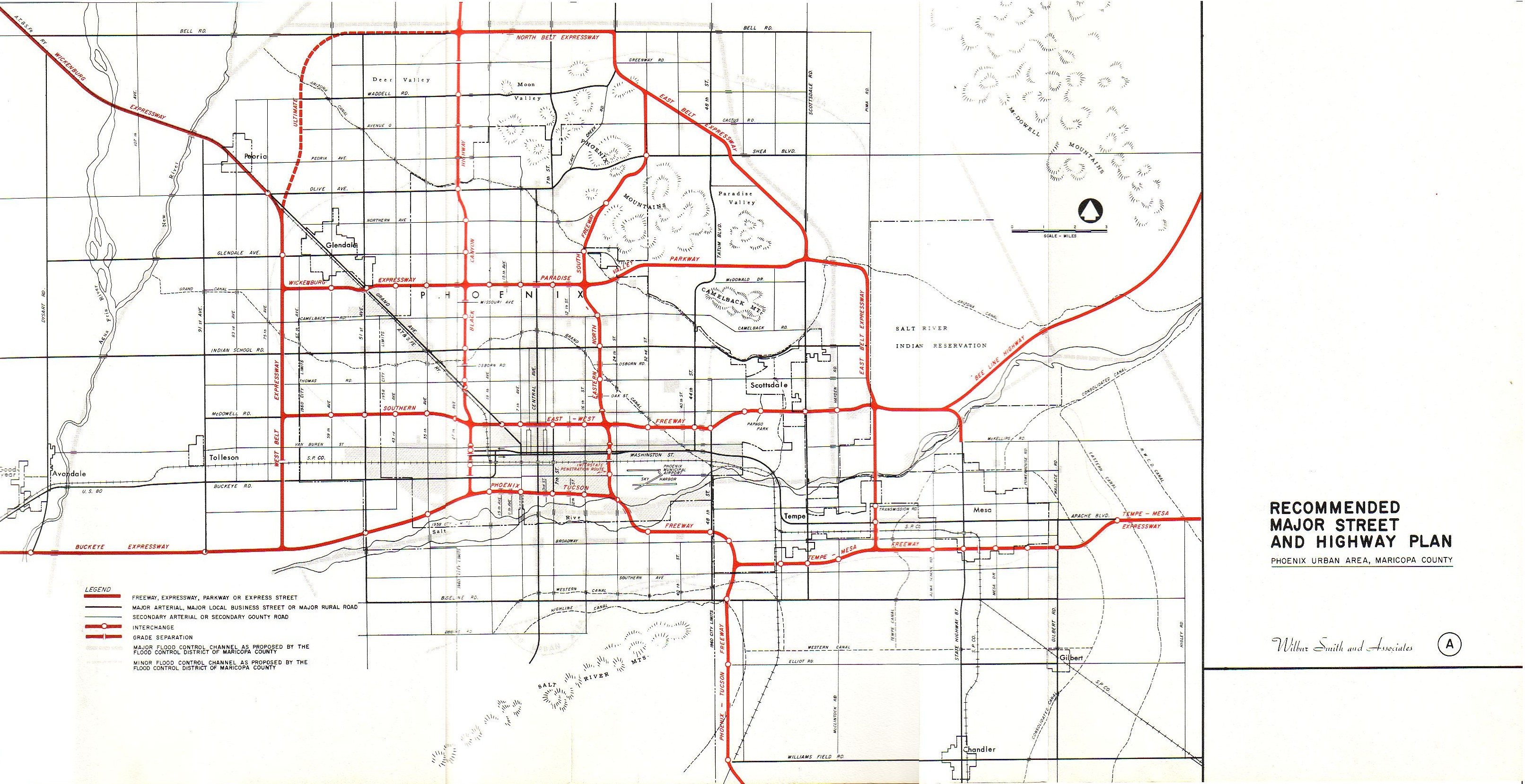
SR 30 is planned to begin at SR 85 along the Hazen Road alignment, about one mile south of downtown Buckeye. It will then travel northeast for 10 miles before intersecting Loop 303 between Broadway Road and Southern Avenue in Goodyear. SR 30 will then head east for five miles before turning southeast at the Agua Fria River and running along the Southern Avenue alignment for two and a half miles. While along the Southern Avenue alignment, frontage roads will accompany the road to provide access to local communities. SR 30 will then head back northeast for seven miles before intersecting Loop 202 just south of Broadway Road in Phoenix. SR 30 will then continue to travel northeast for four and a half miles before meeting its eastern terminus by intersecting the Interstate 17 at the Durango Curve in Phoenix. SR 30 will be 29 miles (47 km) in length when fully complete. [1] [2]

History

A freeway along the planned SR 30 corridor, titled the Buckeye Expressway, was originally proposed in 1957 as the planned route for Interstate 10 into Phoenix. This plan was later abandoned, and I-10 was re-routed northwards along the present Papago Freeway alignment. [3]

In November 2004, Maricopa County voters approved an extension to an existing sales tax funding regional transportation improvements. [4] A significant portion of those funds will go toward improvements of I-10, which experiences significant volumes of traffic in the southwest part of the Valley. However, rapid growth in the neighboring communities of Buckeye, Goodyear, and Avondale is expected to worsen the congestion on I-10, necessitating the construction of a reliever route.

The Arizona Department of Transportation first identified the need for a route along the current SR 30 corridor in June 2005. [5] The route was planned to run parallel to I-10 five miles to the south through the cities to provide relief. It would run through largely undeveloped land, reducing the impact on residential communities. Due to the extension of the sales tax in 2004, funds were available to help build SR 30.

In response to a budget shortfall brought on by the Great Recession, the Maricopa Association of Governments (MAG) voted to suspend funding to numerous projects in October 2009, including SR 30. [5] While not removing SR 30 from the long-term regional transportation plan, the removal of the funding would effectively postpone the construction of the route until at least 2026. The plan had originally indicated a construction timeline between 2021 and 2025.

In October 2016, it was announced that ADOT was exploring the possibility of building SR 30 as a toll road to accelerate its construction. It was met with mixed reviews from the public and ultimately not approved. The toll feasibility study took six months. [6]

On October 26, 2017, local mayors officially named SR 30 the Tres Rios Freeway after the nearby Gila, Agua Fria, and Salt rivers. [7]

In May 2019, the central segment alternative was approved. It was chosen carefully after four years of study comparing four different possible alternatives. [2]

Current status

Funding for SR 30 is reliant on an extension of a regional transportation sales tax that currently ends in 2025. In March 2022, the Arizona Senate passed a bill to put that sales tax extension up for voting in spring 2023, however Governor Doug Ducey vetoed that bill in July 2022. Because of this, the tax extension will have to be placed on a future ballot. If the tax extension is approved, funding would be provided for all three segments. If the tax extension is not approved, that could put the construction of SR 30 in jeopardy. [8] [9]

ADOT is currently in the process of acquiring right-of-way for the central segment. In their five-year plan released in March 2022, ADOT has budgeted funds for this purchase. [10]

Construction of the central segment will not be until at least 2026. There is no timeline for the western and eastern segments yet. [11]

When SR 30 is first constructed, there will be three lanes in each direction. The ultimate configuration allows for four lanes and one high-occupancy vehicle lane (HOV) in each direction. [11]

Exit list

Exit numbers have not yet been assigned. This exit list is based on preliminary studies and may not be the final design plan. [1] [2] Mileposts are determined from the western terminus of the SR 30 project. The entire route is in Maricopa County.

Locationmi [1] kmDestinationsNotes
Buckeye 0.000.00Arizona 85.svg SR 85 Planned interchange and western terminus [1]
2.103.38Miller RoadPlanned interchange [1]
4.206.76Watson RoadPlanned interchange [1]
6.5010.46Baseline RoadPlanned interchange [1]
7.6012.23Perryville RoadPlanned interchange [1]
Goodyear 9.8015.77North plate.svg
Arizona Loop 303.svg
Loop 303 north (Bob Stump Memorial Parkway)
Planned interchange [2]
11.1017.86Cotton LanePlanned interchange with westbound exit and eastbound entrance [2]
12.1019.47Sarival AvenuePlanned interchange with westbound exit and eastbound entrance [2]
13.1021.08Estrella ParkwayPlanned interchange [2]
14.1022.69Bullard AvenuePlanned interchange [2]
Avondale 16.2026.07Dysart Road / El Mirage RoadPlanned interchange [2]
17.3027.84Avondale BoulevardPlanned interchange [2]
18.3029.45107th AvenuePlanned interchange [2]
Phoenix 20.4032.8391st AvenuePlanned interchange [2]
21.4534.5283rd AvenuePlanned interchange [2]
23.3537.5867th AvenuePlanned interchange with eastbound exit and westbound entrance [2]
23.8038.30Arizona Loop 202.svg Loop 202 (Ed Pastor Freeway)Planned interchange [2]
25.1040.3951st AvenuePlanned interchange [1]
27.2043.7735th AvenuePlanned interchange [1]
28.3045.54Lower Buckeye RoadPlanned interchange [1]
29.0046.67I-17.svg I-17 (Black Canyon Freeway) Flagstaff, Tucson Planned interchange and eastern terminus [1]
1.000 mi = 1.609 km; 1.000 km = 0.621 mi
  •       Unopened

See also

Related Research Articles

<span class="mw-page-title-main">Interstate 17</span> Interstate Highway in central Arizona

Interstate 17 (I-17) is a north–south Interstate Highway entirely within the US state of Arizona. I-17's southern terminus lies in Phoenix, at I-10, and its northern terminus is in Flagstaff, at Milton Road north of I-40.

<span class="mw-page-title-main">Arizona State Route 85</span> State highway in Arizona, United States

State Route 85 is a 128.86-mile-long (207.38 km) state highway in the U.S. state of Arizona. The highway runs from the United States–Mexico border near Lukeville to the north ending at Interstate 10 (I-10) in Buckeye. The highway also intersects I-8 in Gila Bend and serves as a connector between I-8 and I-10 and for travelers between Phoenix and Yuma as well as San Diego. SR 85 between I-10 and I-8, as well as I-8 between SR 85 and I-10 in Casa Grande, is touted as a bypass of the Phoenix area for long-distance travelers on I-10.

<span class="mw-page-title-main">Arizona State Route 51</span> Freeway in the Phoenix metropolitan area in Arizona, United States

Arizona State Route 51 (SR 51), also known as the Piestewa Freeway, is a numbered state highway in Phoenix, Arizona. It connects Interstate 10 just outside Downtown Phoenix with Loop 101 on the north side of Phoenix, making it one of the area's major freeways. It is a largely north–south route and is known for traversing the Piestewa Peak Recreation Area. The peak was named after Lori Piestewa, the first Native American woman to die in combat in the U.S. military. Prior to this time, the freeway was known as the Squaw Peak Parkway, a name considered offensive by Native Americans. Rapid growth and increased traffic demand on the east side of Metro Phoenix made the Piestewa Freeway necessary.

<span class="mw-page-title-main">Interstate 11</span> Interstate Highway in the U.S. state of Nevada

Interstate 11 (I-11) is an Interstate Highway that currently runs for 22.8 miles (36.7 km) on a predominantly northwest–southeast alignment in the US state of Nevada, running concurrently with US Route 93 (US 93) between the Arizona state line and Henderson. The freeway is tentatively planned to run from Nogales, Arizona, to the vicinity of Reno, Nevada, generally following the current routes of I-19, I-10, US 93, and US 95. Planners anticipate upgrading two existing highway segments to carry future I-11: US 93 in Arizona from Wickenburg to the Nevada state line on the Mike O'Callaghan–Pat Tillman Memorial Bridge over the Colorado River, and US 95 in Nevada from the Las Vegas Valley to Tonopah. In 2022, officials in Nevada announced that they planned to extend I-11 through the Las Vegas Valley along the existing alignments of I-515/US 93/US 95 to downtown Las Vegas, then running concurrently with US 95 northwest to SR 157. An exact alignment for I-11 has yet to be determined outside of these sections; however, a number of corridor alternatives have been identified for further study and refinement.

<span class="mw-page-title-main">Arizona State Route 101</span> Freeway in the Phoenix metropolitan area, Arizona, United States

Arizona State Route 101 or Loop 101 is a semi-beltway looping around the Phoenix Metropolitan Area in central Arizona. It connects several suburbs of Phoenix, including Tolleson, Glendale, Peoria, Scottsdale, Mesa, Tempe, and Chandler. Construction began in the late-1980s and was completed in 2002.

<span class="mw-page-title-main">Arizona State Route 202</span> Freeway in the Phoenix metropolitan area in Arizona, United States

Arizona State Route 202 (SR 202) or Loop 202 is a semi-beltway circling the eastern and southern areas of the Phoenix metropolitan area in central Arizona. It traverses the eastern end and the southern end of the city of Phoenix, in addition to the cities of Tempe, Mesa, Chandler, and Gilbert, and is a vital route in the metropolitan area freeway system. Loop 202 has three officially designated sections along its route; the Red Mountain Freeway, the SanTan Freeway, and the Congressman Ed Pastor Freeway, previously named the South Mountain Freeway. The Red Mountain Freeway runs from the Mini Stack Interchange with Interstate 10 (I-10) and State Route 51 (SR 51) in Phoenix to the SuperRedTan Interchange with U.S. Route 60 (US 60) in Mesa. The SanTan Freeway runs from there to an interchange with Interstate 10 (I-10) in Chandler. The Congressman Ed Pastor Freeway runs from there to I-10 in western Phoenix.

<span class="mw-page-title-main">Arizona State Route 143</span> Expressway/Freeway in the Phoenix metropolitan area, Arizona, United States

Arizona State Route 143, also known as SR 143 and the Hohokam Expressway, is a north–south and access-controlled freeway in Maricopa County, Arizona, that runs from a junction with Interstate 10 at 48th Street in Phoenix to McDowell Road. The only other major junction along the 3.93-mile (6.32 km) route is with Loop 202, which is located one half-mile south of McDowell Road and the northern terminus.

<span class="mw-page-title-main">Interstate 10 in Arizona</span> Interstate highway in Arizona

In the U.S. state of Arizona, Interstate 10 (I‑10), the major east–west Interstate Highway in the United States Sun Belt, runs east from California, enters Arizona near the town of Ehrenberg and continues through Phoenix and Tucson and exits at the border with New Mexico near San Simon. The highway also runs through the cities of Casa Grande, Eloy, and Marana. Segments of the highway are referred to as either the Papago Freeway, Inner Loop, or Maricopa Freeway within the Phoenix area and the Pearl Harbor Memorial Highway outside metro Phoenix.

<span class="mw-page-title-main">Arizona State Route 153</span> Former state highway in Arizona

State Route 153, also known as SR 153 and the Sky Harbor Expressway, is a former state highway in Maricopa County, in the U.S. state of Arizona, that ran from the intersection of 44th Street and Washington Street in Phoenix south to University Drive. It was a controlled access arterial expressway, with a speed limit of 45 mph (72 km/h), lower than the standard freeway speed of 65 mph (105 km/h). Route 153 was a north–south route that skirted the eastern edge of Sky Harbor International Airport, and along with SR 143, SR 153 served a portion of East Valley residents with access to the airport. Many motorists used SR 143 instead, because of its quick access to and from Interstate 10 and Loop 202. The freeway did, however, provide a direct link to office developments in the Southbank commercial project in east Phoenix with the city of Tempe.

<span class="mw-page-title-main">Arizona State Route 84</span> State highway in Arizona, United States

State Route 84, also known as SR 84, is a 41-mile (66 km) east–west highway in south-central Arizona, with its western terminus at Exit 151 of Interstate 8 and its eastern signed terminus at its junction with State Route 387 and State Route 287 in Casa Grande. An unsigned section, which is mostly maintained by local governments, runs from the SR 287 and SR 387 junction southeast through Arizola and Eloy. East of Eloy, SR 84 is concurrent with the beginning 0.87 miles (1.40 km) of State Route 87 just north of Interstate 10 near Picacho.

<span class="mw-page-title-main">Arizona State Route 74</span> Highway in Arizona

Arizona State Route 74 (SR 74), locally known as the Carefree Highway, is a state highway in central Arizona that stretches east to west from its junction with U.S. Route 60 (US 60) just south of Wickenburg to its junction with Interstate 17 (I-17) in North Phoenix. It serves Lake Pleasant Regional Park and serves as a northern bypass around the often congested stretches of US 60 through the northwest suburbs of the Phoenix metropolitan area. From end to end, it is 30.4 miles (48.9 km) long.

<span class="mw-page-title-main">Arizona State Route 303</span> State highway in Arizona, United States

Arizona State Route 303 or Loop 303, also known as the Bob Stump Memorial Parkway, is a freeway that serves the west part of the Phoenix metropolitan area. The freeway, originally a two-lane rural highway, was maintained by Maricopa County until 2004 when the Arizona Department of Transportation again took control of upgrading the interim road to a freeway.

<span class="mw-page-title-main">Arizona State Route 24</span> Planned state highway in Arizona

State Route 24, also known as the Gateway Freeway or the Williams Gateway Freeway, is a freeway in the extreme southeastern region of the Phoenix Metropolitan Area. The roadway is planned as a controlled-access highway to move traffic from the southeastern suburbs of Phoenix to planned ones in northwestern Pinal County. It is the lowest-numbered state route in Arizona. The first mile from Loop 202 to Ellsworth Road opened on May 4, 2014. An extension to Ironwood Drive opened in 2022, with the completion of "Interim Phase II"; the first mile of this extension from Ellsworth Road to Williams Field Road opened on April 1, 2022, with the remainder following on August 11. Planning for future sections has been halted until studies for the Pinal North-South Freeway are completed to confirm how the two freeways will intersect.

<span class="mw-page-title-main">U.S. Route 60 in Arizona</span> Section of U.S. Highway in Arizona, United States

U.S. Route 60 (US 60) is an east–west United States Highway within Arizona. The highway runs for 369 miles (594 km) from a junction with Interstate 10 near Quartzsite to the New Mexico State Line near Springerville. As it crosses the state, US 60 overlaps at various points: I-17, I-10, SR 77, SR 260, US 191, and US 180. Between Wickenburg and Phoenix, the route is known as Grand Avenue. From Tempe to Apache Junction, it is known as the Superstition Freeway.

<span class="mw-page-title-main">U.S. Route 93 in Arizona</span> Highway in Arizona

U.S. Route 93 in the state of Arizona is a United States Numbered Highway that begins in Wickenburg and heads north to the Nevada state line at the Mike O'Callaghan–Pat Tillman Memorial Bridge.

The metropolitan area of Phoenix in the U.S. state of Arizona contains one of the nation's largest and fastest-growing freeway systems, with over 1,405 lane miles (2,261 km) as of 2005.

Below is a list and summary of the former state highways.

<span class="mw-page-title-main">Unconstructed state routes in Arizona</span>

Below is a list and summary of the unconstructed state highways in the U.S. state of Arizona. Some are currently proposed while the others have since been cancelled prior to being constructed.

Transportation in Phoenix, Arizona is primarily via private cars. Public transport is run under the brand Valley Metro, and consists of buses and a light rail system.

Northern Parkway is a limited-access road in Maricopa County, Arizona that serves the west part of the Phoenix metropolitan area. Northern Parkway was first opened in December 2013. Northern Parkway currently ends at the Agua Fria River but is planned to extend to the US 60.

References

  1. 1 2 3 4 5 6 7 8 9 10 11 12 13 14 "MAJOR REGIONAL TRANSPORTATION PLAN AMENDMENT Arizona State Route 30" (PDF). Maricopa Association of Governments . May 10, 2017. Retrieved April 21, 2022.
  2. 1 2 3 4 5 6 7 8 9 10 11 12 13 14 15 "State Route 30: Loop 303 to Loop 202 Study". Arizona Department of Transportation. April 28, 2020. Retrieved April 21, 2022.
  3. "Recommended Major Street and Highway Plan" . Retrieved April 29, 2023.
  4. "About MAG: Proposition 300 and 400". Maricopa Association of Governments. Retrieved February 26, 2022.
  5. 1 2 "State Route 30 (SR 30) Study – SR 303L to SR 202L Public Hearing" (PDF). Arizona Department of Transportation. May 11, 2019. Retrieved February 26, 2022.
  6. "ADOT taking closer look at toll road options in Phoenix area". KPNX . October 4, 2016. Retrieved February 26, 2022.
  7. "New proposed Valley freeway, State Route 30, named 'Tres Rios'". ABC 15 Phoenix. October 26, 2017. Retrieved April 21, 2022.
  8. Christie, Bob (March 17, 2022). "Senate OKs sending transportation tax to Maricopa County voters". FOX 10 Phoenix. Retrieved November 30, 2022.
  9. Estes, Christina (October 14, 2022). "Why business, political leaders want Arizona governor to reconsider transportation tax". KJZZ. Retrieved November 30, 2022.
  10. "2023-2027 Five-Year Transportation Facilities Construction Program" (PDF). Arizona Department of Transportation. March 18, 2022. p. 184. Retrieved April 21, 2022.
  11. 1 2 "State Route (SR) 30: SR 303L to SR 202L Location/Design Concept Report" (PDF). Arizona Department of Transportation. April 2020. pp. 6, 80. Retrieved November 30, 2022.
Template:Attached KML/Arizona State Route 30
KML is not from Wikidata