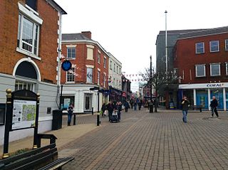
Hinckley is a market town in south-west Leicestershire, England. It is administered by Hinckley and Bosworth Borough Council. Hinckley is the second largest town in the administrative county of Leicestershire, after Loughborough.

Burbage is a village in England. According to the United Kingdom Census 2001 the parish had a population of 14,324, increasing to 14,568 at the 2011 census.

Dadlington is a hamlet administered by Hinckley and Bosworth District Council in Leicestershire, England. It is situated between Hinckley, Market Bosworth and Nuneaton.

Hungarton is a small village and civil parish in the Harborough district, in the county of Leicestershire, England, about 10 miles (16 km) north-east of Leicester and 13 miles (21 km) south-west of Melton Mowbray. The population of the civil parish was 269 at the 2001 census, including Ingarsby, and increased to 289 at the 2011 census.

Ibstock is a town and civil parish about 2.5 miles (4 km) south of Coalville in North West Leicestershire, England. The population of the civil parish was 5,760 at the 2001 census increasing to 6,201 at the 2011 census.

Catworth is a village and civil parish in Cambridgeshire, England. Catworth lies approximately 9 miles (14 km) west of Huntingdon. The civil parish covers an area of 3,094 acres. Catworth village has two parts, Catworth, at the top of the hill, and Little Catworth, at the bottom. Catworth is situated within Huntingdonshire which is a non-metropolitan district of Cambridgeshire as well as being a historic county of England.

Stretton-on-Dunsmore is a village and civil parish in the English county of Warwickshire. Its population in the 2001 census was recorded as 1,143, rising slightly to 1,159 at the 2011 census. In the 19th century the population was 634. The village is situated just south of the A45 trunk road, approximately midway between Rugby and Coventry. Administratively, Stretton is part of the borough of Rugby.

Austrey is a village and civil parish in the North Warwickshire District of Warwickshire, England. and the village lies at the northern extremity of the County.

Witherley is a village and civil parish in the Hinckley and Bosworth district of Leicestershire, England. The civil parish of Witherley includes Atterton, Fenny Drayton, and Ratcliffe Culey as well as the village of Witherley itself. The population of the civil parish at the 2011 census was 1,373.
Aston Flamville is a village and civil parish in the Blaby district in Leicestershire, England. It is situated near Hinckley, but on the other (eastern) side of the M69. It has a population of 150 and consequently has a parish meeting rather than a parish council. The population at the 2011 census had increased to 311.

Sharnford is a village and civil parish in Blaby of Leicestershire. The parish has a population of about 1,000, measured at the 2011 census as 985. The village is about four miles east of Hinckley, and is near to Aston Flamville, Wigston Parva and Sapcote.

Seagrave is a village and civil parish in the Charnwood district of Leicestershire, England. It has a population of around 500, measured at the 2011 census as 546, It is north of Sileby and close to Thrussington and Barrow upon Soar.

Ashby Magna is a small English village and civil parish in the Harborough district of Leicestershire. The parish has a population of 294, increasing at the 2011 census to 347. It is in the west of the district, and lies midway between junctions 20 and 21 of the M1. Nearby places are Willoughby Waterleys, Peatling Parva and Dunton Bassett.

Higham on the Hill is a village and civil parish in the Hinckley and Bosworth district of Leicestershire, England. The population at the 2011 census was 840.

Sheepy is a civil parish in the Borough of Hinckley and Bosworth in Leicestershire, England. It contains the villages of Sheepy Magna, Sheepy Parva, Sibson, Wellsborough, Upton, Pinwall and Cross Hands—a total of 449 homes. At the 2001 census, the parish had a population of 1,192, including Orton on the Hill but falling slightly to 1,174 at the 2011 census.

Sibson is a village in western Leicestershire, close to the border with North Warwickshire. It is situated approximately midway between the towns of Hinckley and Measham, and slightly northeast of Atherstone.

Orton on the Hill is a small village forming part of the Twycross civil parish in the Hinckley and Bosworth district of Leicestershire, England. It is furthermore located in the Sparkenhoe Hundred. The name is derived from its high situation on a hill overlooking four counties,. Orton adjoins Morebarne, Sheepy and Newhouse Grange on the south, Appleby and Austrey to the east. The population of the village is included in the civil parish of Sheepy.

Appleby Parva, or Little Appleby, part of the parish of Appleby Magna in Leicestershire, is a hamlet about 1 mile (1.6 km) south-west of Appleby church. It straddles the A444, south of the crossroads of the highways from Ashby de la Zouch to Tamworth, from Atherstone to Burton upon Trent and Junction 11 of the M42/A42. Appleby Magna and Appleby Parva are usually collectively known as Appleby.
Moreton Morrell is a village and civil parish in the county of Warwickshire, England. It is part of the historic hundred of Kington and is located about three and a half miles north west of the village of Kineton. The settlement was first mentioned in the Domesday Book as Moreton. From at least Norman times, it has consisted of the village of Moreton and the hamlet of Morrell. The parish of Moreton Morrell is bounded on the east and south east by the Fosse Way, and consists of Little Morrell in the north, the village of Moreton Morrell, and Moreton Paddox in the south.
Peatling Parva is a village and civil parish in the Harborough district, south Leicestershire, England. It lies 2.6 km west-north-west of Ashby Magna and 2.9 km south-south-west of Peatling Magna.

