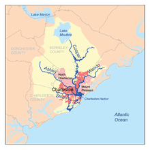
Charleston is the most populous city in the U.S. state of South Carolina, the county seat of Charleston County, and the principal city in the Charleston metropolitan area. The city lies just south of the geographical midpoint of South Carolina's coastline on Charleston Harbor, an inlet of the Atlantic Ocean formed by the confluence of the Ashley, Cooper, and Wando rivers. Charleston had a population of 150,277 at the 2020 census. The 2020 population of the Charleston metropolitan area, comprising Berkeley, Charleston, and Dorchester counties, was 799,636 residents. It ranks as the third-largest metropolitan statistical area in the state, the 8th-largest in the Deep South and the 74th-largest in the United States.

Charleston County is located in the U.S. state of South Carolina along the Atlantic coast. As of the 2020 census, the population was 408,235, making it the third most populous county in South Carolina. Its county seat is Charleston. It is also the largest county in the state by total area, although Horry County has a larger land area. The county was created in 1800 by an act of the South Carolina State Legislature.
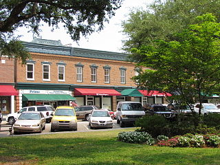
Summerville is a town in the U.S. state of South Carolina situated mostly in Dorchester County, with small portions in Berkeley and Charleston counties. It is part of the Charleston-North Charleston-Summerville, SC Metropolitan Statistical Area. Summerville's population at the 2020 census was 50,915.

North Charleston is a city in Berkeley, Charleston, and Dorchester counties within the U.S. state of South Carolina. As of the 2020 census, North Charleston had a population of 114,852, making it the 3rd-most populous city in the state, and the 248th-most populous city in the United States. North Charleston is a principal city within the Charleston-North Charleston, SC Metropolitan Statistical Area, which had a population of 799,636 in 2020.

The Province of Carolina was a province of the Kingdom of England (1663–1707) and later the Kingdom of Great Britain (1707–1712) that existed in North America and the Caribbean from 1663 until partitioned into North and South on January 24, 1712. It consisted of all or parts of present-day Alabama, Florida, Georgia, Mississippi, North Carolina, South Carolina, and Tennessee.

The Waccamaw River is a river, approximately 140 miles (225 km) long, in southeastern North Carolina and eastern South Carolina in the United States. It drains an area of approximately 1,110 square miles (2886 km²) in the coastal plain along the eastern border between the two states into the Atlantic Ocean. Along its upper course, it is a slow-moving, blackwater river surrounded by vast wetlands, passable only by shallow-draft watercraft such as canoe. Along its lower course, it is lined by sandy banks and old plantation houses, providing an important navigation channel with a unique geography, flowing roughly parallel to the coast.

The Cooper River is a mainly tidal river in the U.S. state of South Carolina. The cities of Mt. Pleasant, Charleston, North Charleston, Goose Creek, Moncks Corner, and Hanahan are located along the river. Short and wide, the river is joined first by the blackwater East Branch and then farther downstream at the tidal Wando River. Almost immediately thereafter, the Cooper River widens into its estuary and unites with the Ashley River to form the Charleston Harbor.
Wadmalaw Island is an island located in Charleston County, South Carolina, United States. It is one of the Sea Islands, a chain of tidal and barrier islands on the Atlantic Ocean.

The Chowan River (cho-WAHHN) is a blackwater river formed with the merging of Virginia's Blackwater and Nottoway rivers near the stateline between Virginia and North Carolina. According to the USGS a variant name is Choan River.
Dorchester was a town in the Province of South Carolina. Situated on the Ashley River about 18 miles (29 km) from Charleston, it was founded in February 1696 by followers of Reverend Joseph Lord from Dorchester, Massachusetts.

South Carolina Highway 61 (SC 61) is a 67-mile-long (108 km) state highway in the U.S. state of South Carolina. The highway is designated on a north–south direction, but physically travels in an east–west direction, from SC 30 in Charleston to U.S. Route 78 (US 78) near Branchville. The portion of SC 61 from Church Creek Bridge and 10 miles (16 km) north is designated a National Scenic Byway.

The Blackwater River of southeastern Virginia flows from its source near the city of Petersburg, Virginia for about 105 miles (170 km) through the Inner Coastal Plain region of Virginia. The Blackwater joins the Nottoway River to form the Chowan River, which empties into Albemarle Sound. The Blackwater-Nottoway confluence forms the boundary between Virginia and North Carolina.

Magnolia Plantation and Gardens is a historic house with gardens located on the Ashley River at 3550 Ashley River Road west of Ashley, Charleston County, South Carolina. It is one of the oldest plantations in the South, and listed on the National Register of Historic Places. Magnolia Plantation is located near Charleston and directly across the Ashley River from North Charleston. The house and gardens are open daily; an admission fee is charged.

West Ashley, or more formally, west of the Ashley, is one of the six distinct areas of the city proper of Charleston, South Carolina. As of July 2022, its estimated population was 83,996. Its name is derived from the fact that the land is west of the Ashley River.

Ashley River Historic District is a historic district located west of the Ashley in the South Carolina Lowcountry in Charleston, South Carolina, United States. The Historic District includes land from five municipalities, almost equally split between Charleston and Dorchester counties. The district includes dry land, swamps, and marshes of the Rantowles Creek and Stono Swamp watershed.
The Coastal Carolina Council is the Boy Scouts of America council that services much of the South Carolina Lowcountry. It operates 6 districts and two scout camps—Camp Ho Non Wah and Camp Moultrie.

South Carolina Highway 165 (SC 165) is a 28.393-mile (45.694 km) state highway in the U.S. state of South Carolina. It connects Yonges Island to U.S. Route 17 (US 17) in Ravenel and US 17 Alternate in Summerville.

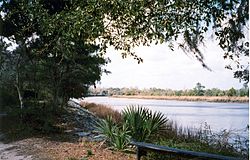
Colonial Dorchester State Historic Site sits along the Ashley River, near the town of Summerville in Dorchester County, South Carolina. In 1969, the site was donated to the South Carolina State Park Service and was added to the National Register of Historic Places on December 2, 1969. Currently the site of a 325-acre park, Old Dorchester State Park offers visitors a glimpse into South Carolina's Colonial past. The park boasts one of the most well-preserved oyster-shell tabby forts in the country, St. George's Bell Tower, log shipping wharves, burial sites and cemeteries, as well as on-going archaeological digs that are still unearthing the settlement's history.

Wambaw Swamp is a swamp in northeastern Charleston County, South Carolina. It is located entirely within the Francis Marion National Forest and contains 4,755 acres (19 km2), all of which is designated as a wilderness area. This forest wetland is a mix of river-bottom hardwood and pine. To the southeast lies the Little Wambaw Swamp Wilderness, a 4,967 acres (20 km2) wilderness area managed by the U.S. Forest Service. The area is similar to the main Wambaw Swamp ecologically with more high ground for walking and camping. Wambaw Creek Wilderness protects 1,832 acres (7 km2) of the watershed along the Charleston and Berkeley County line as it leaves the swamps and empties into the South Santee River near Hampton Plantation State Historic Site.