Colonial Dorchester State Historic Site

Last updated

Colonial Dorchester State Historic Site
Church Ruins in Old Dorchester.jpg
Cemetery and ruins of the St. George Bell Tower
Colonial Dorchester State Historic Site
Nearest city Summerville, SC
Coordinates 32°56′58″N80°10′19″W / 32.9495°N 80.1719°W / 32.9495; -80.1719 Coordinates: 32°56′58″N80°10′19″W / 32.9495°N 80.1719°W / 32.9495; -80.1719
Area325 acres (1 km2)
Open1960

Colonial Dorchester State Historic Site sits along the Ashley River, near the town of Summerville in Dorchester County, South Carolina. In 1969, the site was donated to the South Carolina State Park Service and was added to the National Register of Historic Places on December 2, 1969. [1] Currently the site of a 325-acre park, Old Dorchester State Park offers visitors a glimpse into South Carolina's Colonial past. The park boasts one of the most well-preserved oyster-shell tabby forts in the country, St. George's Bell Tower, log shipping wharves, burial sites and cemeteries, as well as on-going archaeological digs that are still unearthing the settlement's history. [2]

Contents

History

The historic site is situated on the Ashley River where the town of Dorchester once stood. The site of the town of Dorchester is on a neck of land between the Ashley River and Dorchester Creek, originally known as Boshoe Creek. [3]

Founding

In 1675, John and Mary Smith came to Carolina from England. On November 20, 1676 the Earl of Shaftsbury granted 1,800 acres of land to John Smith, which included the future Dorchester site. [3] John Smith's land grant was situated on Boshoe Creek, in Boshoe Swamp; subsequently, he became known as "John Smith of Boo-shoo." [3] In December 1682, John Smith died and his widow married Arthur Middleton, and when he died in 1684, she married Ralph Izard. Because John Smith had no children, his land grant lapsed after he died and ownership of the land went to the state. [4]

In January 1696, small group of settlers from the township of Dorchester, Massachusetts acquired 4,050 acres, including the 1,800 acres along the Boshoe Creek and Ashley River. After receiving permission from the Dorchester church of Massachusetts, Reverend Joseph Lord and his Congregationalist parishioners, considering themselves missionaries and ready to "settle the gospel, " ventured to Carolina to settle this land. [4] On Sunday, January 26, 1696, the Reverend Lord preached his first sermon at the place selected for the church building. [3] The new settlers quickly began planning and building the town's first church, which was eventually known as St. George's Anglican Church, or the Parish Church of St. George. [5] After the church was established, the town of Dorchester quickly developed and more settlers came from Massachusetts.

A Thriving Economy

The site's advantageous location helped the town thrive - nearby roads led to Charleston and to the interior of the colony and the Ashley River provided a convenient highway for the shipment of goods and produce. [5] Trade with Native Americans, the development of rice and indigo as cash crops and a growing population, helped secure Dorchester's economic peak in the mid 1700s. [6] During this time, wealthy planters, merchants and plantation owners continued to reap the benefits of this trading town, which remained relatively small through most of its hundred-year existence, and the town continued to be a bustling commercial center for trade. [7] A fair was established in 1723, and a Free School in 1734; by 1781 Dorchester had about 40 houses. [8]

St. George's Anglican Church Bell Tower Dorchester Church Tower, Dorchester Creek Junction, Ashley River, north bank (Dorchester County, South Carolina).jpg
St. George's Anglican Church Bell Tower

The Church & Bell Tower

Built in the center of Dorchester, St. George's Anglican Church was originally erected and completed in 1719 and the Bell Tower, which stands today, was added in 1751. [9] As Dorchester was being turned into an armed camp for American forces at the beginning of the Revolution, a plan was submitted for fortifying St. George's Church. Exactly how the church was to be fortified remains a mystery, for the plan has never been found. When British troops occupied Dorchester later in the war they used the large church and burned it before they were chased out of the village in December 1781. [10] The church was eventually repaired but, like the town around it, was soon abandoned. Scavengers removed bricks from the decayed sanctuary just as they took away bricks from other buildings in town. An 1858 magazine article on Dorchester noted, "Rumor says, they were afraid to touch the tower, because there was a chance of its falling on them, and therefore it remains." [5] The Earthquake of 1886 that devastated Charleston, split the tower along its height and for many years after, it was held together with iron straps until it was repaired in the early 1960s.

The Fort & Powder Magazine

Dorchester's location made it a strategic military site. [5] Fear of a possible French invasion prompted the construction of a powder magazine and fort from 1757 to 1760. [5] Originally designed to be constructed using brick, the fort and powder magazine were eventually made of tabby, a concrete material made of lime, sand and oyster shells. While local materials were used in the construction of the fort, in design it was a simplified version of classic European fortification. The walls formed a rectangle around the magazine, with sections called half-bastions projecting from each corner. From these strong points, soldiers could direct deadly fire down the length of adjoining walls. [5] The French invasion never came, though, and the town apparently saw little activity until the American Revolution in 1775.

Located in Colonial Dorchester State Historical site Ft. Dorchester is the best-preserved tabby fortification in the country. Tabby Walls of Ft. Dorchester.jpg
Located in Colonial Dorchester State Historical site Ft. Dorchester is the best-preserved tabby fortification in the country.

In preparation of the impending war, the little town of Dorchester was transformed into a military depot and American troops assembled in town. In 1775 the magazine was fortified and the fort was commanded by Capt. Francis Marion. [11] After Charleston fell to the British in May 1780, Dorchester became an outpost for British and Loyalist troops. In December 1781, American forces, led by Colonel Wade Hampton and General Nathanael Greene, advanced on the town and the British were driven out of Dorchester. [11]

After the war, the fort housed a tile yard, with the magazine converted into a kiln for firing clay roofing tiles. But like the rest of town, the fort was soon abandoned. Its history was forgotten. Some people assumed it had been built by the Spanish, and many asserted that it had been built to provide protection from Indians. Locals eventually gave it the name "Fort Dorchester," even though it never had an official name while it was in use. [5]

The walls of Fort Dorchester, from the Ashley River Fortdorchester.jpg
The walls of Fort Dorchester, from the Ashley River

Downfall

Seemingly, the town never recovered after the war, though the reasons given by historians for Dorchester's decline are many and varied. They range from the devastation wrought by British and Loyalist soldiers to the malaria that plagued the swampy area. [5] In 1788, a traveler wrote,

I passed Dorchester, where there are the remains of what appears to have once been a considerable town: there are the ruins of an elegant church, and the vestiges of several well-built houses. [12]

As Dorchester was abandoned, it was succeeded by a new town, Summerville, that developed close by on higher, better-drained land. Bricks from buildings in the older town were even removed for use in structures in the new town.

Activities & Amenities

Hours & Admission

Related Research Articles

<span class="mw-page-title-main">Charleston, South Carolina</span> Largest city in the U.S. state of South Carolina

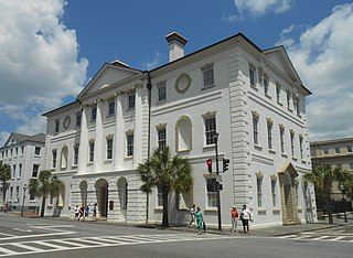
Charleston is the largest city in the U.S. state of South Carolina, the county seat of Charleston County, and the principal city in the Charleston–North Charleston metropolitan area. The city lies just south of the geographical midpoint of South Carolina's coastline on Charleston Harbor, an inlet of the Atlantic Ocean formed by the confluence of the Ashley, Cooper, and Wando rivers. Charleston had a population of 150,277 at the 2020 census. The 2020 population of the Charleston metropolitan area, comprising Berkeley, Charleston, and Dorchester counties, was 799,636 residents, the third-largest in the state and the 74th-largest metropolitan statistical area in the United States.

<span class="mw-page-title-main">Dorchester County, South Carolina</span> County in South Carolina, United States

Dorchester County is a county located in U.S. state of South Carolina. As of the 2020 census, the population was 161,540. Its county seat is St. George.

<span class="mw-page-title-main">Charleston County, South Carolina</span> County in South Carolina, United States

Charleston County is located in the U.S. state of South Carolina along the Atlantic coast. As of the 2020 census, its population was 408,235, making it the third most populous county in South Carolina. Its county seat is Charleston. The county was created in 1800 by an act of the South Carolina State Legislature.

<span class="mw-page-title-main">Berkeley County, South Carolina</span> County in South Carolina, United States

Berkeley County is a county in the U.S. state of South Carolina. As of the 2020 census, its population was 229,861. Its county seat is Moncks Corner. After two previous incarnations of Berkeley County, the current county was created in 1882. Berkeley County is included in the Charleston-North Charleston, SC Metropolitan Statistical Area.

<span class="mw-page-title-main">Darien, Georgia</span> City in Georgia, United States

Darien is a city in and the county seat of McIntosh County, Georgia, United States. It lies on Georgia's coast at the mouth of the Altamaha River, approximately 50 miles south of Savannah, and is part of the Brunswick, Georgia Metropolitan Statistical Area. It is the second oldest planned city in Georgia and was originally called New Inverness. The population of Darien was 1,975 at the 2010 census.

<span class="mw-page-title-main">Summerville, South Carolina</span> Town in South Carolina, United States

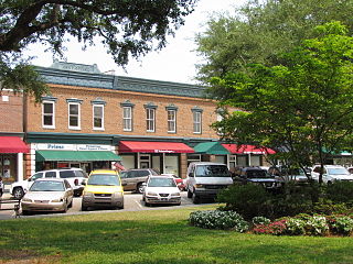
Summerville is a town in the U.S. state of South Carolina situated mostly in Dorchester County, with small portions in Berkeley and Charleston counties. It is part of the Charleston-North Charleston-Summerville Metropolitan Statistical Area. Summerville's population at the 2020 census was 50,915.

<span class="mw-page-title-main">North Charleston, South Carolina</span> City in South Carolina, United States

North Charleston is the third-largest city in the state of South Carolina. On June 12, 1972, the city of North Charleston was rated as the ninth-largest city in South Carolina. As of the 2020 census, North Charleston had a population of 114,852, and the area is 76.6 square miles (198.5 km2). As defined by the U.S. Office of Management and Budget, for use by the U.S. Census Bureau and other U.S. Government agencies for statistical purposes only, North Charleston is included within the Charleston–North Charleston–Summerville metropolitan area and the Charleston-North Charleston urban area.

<span class="mw-page-title-main">Fort Frederica National Monument</span>

Fort Frederica National Monument, on St. Simons Island, Georgia, preserves the archaeological remnants of a fort and town built by James Oglethorpe between 1736 and 1748 to protect the southern boundary of the British colony of Georgia from Spanish raids. About 630 British troops were stationed at the fort.

<span class="mw-page-title-main">Ashley River</span> River in South Carolina, United States

The Ashley River is a blackwater and tidal river in South Carolina, rising from the Wassamassaw and Great Cypress Swamps in western Berkeley County. It consolidates its main channel about five miles west of Summerville, widening into a tidal estuary just south of Fort Dorchester. The river then flows for approximately 17 mi (27 km) along the historical banks of the City of North Charleston before reaching peninsular Charleston. The much wider Ashley joins the Cooper River off the Battery in Charleston to form Charleston Harbor before discharging into the Atlantic Ocean. As of 2012 the land around the Ashley River is mostly undeveloped.

The Cherokee Path was the primary route of English and Scots traders from Charleston to Columbia, South Carolina in Colonial America. It was the way they reached Cherokee towns and territories along the upper Keowee River and its tributaries. In its lower section it was known as the Savannah River. They referred to these towns along the Keowee and Tugaloo rivers as the Lower Towns, in contrast to the Middle Towns in Western North Carolina and the Overhill Towns in present-day southeastern Tennessee west of the Appalachian Mountains.

<span class="mw-page-title-main">Historic Jamestown</span> Cultural heritage site in Virginia, United States

Historic Jamestown is the cultural heritage site that was the location of the 1607 James Fort and the later 17th-century town of Jamestown in America. It is located on Jamestown Island, on the James River at Jamestown, Virginia and operated as a partnership between Preservation Virginia and the U.S. National Park Service as part of Colonial National Historical Park.

Dorchester was a town in the Province of South Carolina. Situated on the Ashley River about 18 miles (29 km) from Charleston, it was founded in February 1696 by followers of Reverend Joseph Lord from Dorchester, Massachusetts.

<span class="mw-page-title-main">South Carolina Highway 61</span> United States historic place

South Carolina Highway 61 (SC 61) is a 67-mile-long (108 km) state highway in the U.S. state of South Carolina. The highway is designated on a north–south direction, but physically travels in an east–west direction, from SC 30 in Charleston to U.S. Route 78 (US 78) near Branchville. The portion of SC 61 from Church Creek Bridge and 10 miles (16 km) north is designated a National Scenic Byway.

<span class="mw-page-title-main">West Ashley</span>

West Ashley, or more formally, west of the Ashley, is one of the six distinct areas of the city proper of Charleston, South Carolina. As of July 2022, its estimated population was 83,996. Its name is derived from the fact that the land is west of the Ashley River.

<span class="mw-page-title-main">Ashley River Historic District</span> Historic district in South Carolina, United States

Ashley River Historic District is a historic district located west of the Ashley in the South Carolina Lowcountry near Charleston, South Carolina, United States. The Historic District includes land from five municipalities, almost equally split between Charleston and Dorchester counties. The district includes dry land, swamps, and marshes of the Rantowles Creek and Stono Swamp watershed.

<span class="mw-page-title-main">St. Philip's Church (Charleston, South Carolina)</span> Historic church in South Carolina, United States

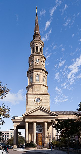
St. Philip's Church is an historic church at 142 Church Street in Charleston, South Carolina. Its National Historic Landmark description states: "Built in 1836, this stuccoed brick church features an imposing tower designed in the Wren-Gibbs tradition. Three Tuscan pedimented porticoes contribute to this design to make a building of the highest quality and sophistication." On November 7, 1973, it was added to the National Register of Historic Places and designated a National Historic Landmark.

Dorchester School District Two is a school district based in Summerville, South Carolina, United States.

<span class="mw-page-title-main">South Carolina Highway 165</span> State highway in South Carolina

South Carolina Highway 165 (SC 165) is a 28.393-mile (45.694 km) state highway in the U.S. state of South Carolina. It connects Yonges Island to U.S. Route 17 (US 17) in Ravenel and US 17 Alternate in Summerville.

Granby was the first European settlement in the area of present-day Columbia in the U.S. state of South Carolina. Settlement began around 1718 with the establishment of a trading post by the British on the Congaree River. Many small farms were settled by German, Swiss, and Scots-Irish immigrants. Granby was the largest town and county seat of Lexington County until the early 19th century, when the town began to gradually decline as Columbia, the state capital, grew. The once thriving colonial town was mostly unoccupied after the first quarter of the 19th century. Today, the area is part of present-day Cayce.

References

  1. "National Register Properties in South Carolina". September 9, 2013.
  2. "By the Numbers". September 5, 2013.
  3. 1 2 3 4 Smith, H. A. M.. (1905). The Town of Dorchester, in South Carolina: A Sketch of Its History. The South Carolina Historical and Genealogical Magazine, 6(2), 62–95. Retrieved from http://www.jstor.org/stable/27575096
  4. 1 2 "Colonial Dorchester State Park, South Carolina History". myschistory.com. Retrieved February 24, 2016.
  5. 1 2 3 4 5 6 7 8 "Colonial Dorchester - WebQuest". teachingushistory.org. Retrieved February 24, 2016.
  6. "Colonial Dorchester Marker". hmdb.org. Retrieved February 24, 2016.
  7. "Colonial Dorchester Marker". hmdb.org. Retrieved February 24, 2016.
  8. "Old Dorchester Marker". hmdb.org. Retrieved February 24, 2016.
  9. "The Bell Tower of St. George's Marker". hmdb.org. Retrieved February 24, 2016.
  10. "Parish Church of St. George, Dorchester Marker". hmdb.org. Retrieved February 24, 2016.
  11. 1 2 "Fort Dorchester Marker". hmdb.org. Retrieved February 24, 2016.
  12. "History & Interpretation at Colonial Dorchester". southcarolinaparks.com. Retrieved February 24, 2016.